
West Norwood Cemetery is a 40-acre (16 ha) rural cemetery in West Norwood in London, England. It was also known as the South Metropolitan Cemetery. One of the first private landscaped cemeteries in London, it is one of the "Magnificent Seven" cemeteries of London, and is a site of major historical, architectural and ecological interest.

Kew Gardens is a neighborhood in the central area of the New York City borough of Queens. Kew Gardens is bounded to the north by the Union Turnpike and the Jackie Robinson Parkway, to the east by the Van Wyck Expressway and 131st Street, to the south by Hillside Avenue, and to the west by Park Lane, Abingdon Road, and 118th Street. Forest Park is to the west and the neighborhood of Forest Hills to the north-west, Flushing Meadows–Corona Park north, Richmond Hill south, Briarwood southeast, and Kew Gardens Hills east.

Tower Hamlets Cemetery Park is a local nature reserve and historic cemetery in the London Borough of Tower Hamlets within the East End of London. It is regarded as one of the seven great cemeteries of the Victorian era, the "Magnificent Seven", instigated because the normal church burial plots had become overcrowded.

Richmond Hill is a commercial and residential neighborhood located in the southeastern section of the New York City borough of Queens. The area borders Kew Gardens and Forest Park to the north, Jamaica and South Jamaica to the east, South Ozone Park to the south, and Woodhaven and Ozone Park to the west. The neighborhood is split between Queens Community Board 9 and 10.

The Briarwood station is a local station on the IND Queens Boulevard Line of the New York City Subway. Located at the intersection of 84th Drive, Main Street, Queens Boulevard, and the Van Wyck Expressway, in Briarwood, Queens, bordering Kew Gardens, it is served by the F train at all times, the E train at all times except rush hours and middays, and the <F> train during rush hours in the reverse peak direction.
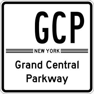
The Grand Central Parkway (GCP) is a 14.61-mile (23.51 km) controlled-access parkway that stretches from the Triborough Bridge in New York City to Nassau County on Long Island. At the Queens–Nassau border, it becomes the Northern State Parkway, which runs across the northern part of Long Island through Nassau County and into Suffolk County, where it ends in Hauppauge. The westernmost stretch also carries a short stretch of Interstate 278 (I-278). The parkway runs through Queens and passes the Cross Island Parkway, Long Island Expressway, LaGuardia Airport and Citi Field, home of the New York Mets. The parkway is designated New York State Route 907M (NY 907M), an unsigned reference route. Despite its name, the Grand Central Parkway was not named after Grand Central Terminal.

The 75th Avenue station is a local station on the IND Queens Boulevard Line of the New York City Subway. Located at the intersection of 75th Avenue and Queens Boulevard in Forest Hills, Queens, it is served by the F train at all times, the E train at all times except weekday rush hours and middays, and the <F> train during rush hours in the reverse peak direction.

Forest Park is a park in the New York City borough of Queens, spanning 538 acres (218 ha). It is the tenth-largest park in New York City and the third-largest in Queens. Created on August 9, 1895, it was originally referred to as Brooklyn Forest Park, as the area was part of Brooklyn at the time.

Kew Gardens Hills is a neighborhood in the middle of the New York City borough of Queens. The borders are Flushing Meadows-Corona Park to the west, the Long Island Expressway to the north, Union Turnpike to the south, and Parsons Boulevard to the east.
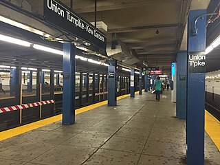
The Kew Gardens–Union Turnpike station is an express station on the IND Queens Boulevard Line of the New York City Subway. Located at Union Turnpike and Queens Boulevard on the border of Kew Gardens and Forest Hills, Queens, it is served by the E and F trains at all times, and the <F> train during rush hours in the reverse peak direction. Despite the station's name, Union Turnpike forms the border between Kew Gardens and Forest Hills, and the station straddles that border, with multiple entrances located in each neighborhood.

Undercliffe Cemetery is located between Otley Road and Undercliffe Lane in the Bolton and Undercliffe ward, Bradford, West Yorkshire, England. The cemetery stands atop a hillside overlooking the city and contains some very impressive Victorian funerary monuments in a variety of styles. It is a notable example of a Victorian cemetery where a number of rich and prominent local residents have been buried, notably mill owners and former mayors. Undercliffe Cemetery is grade II* listed by English Heritage in their Register of Parks and Gardens of Special Historic Interest in England.

The 63rd Drive–Rego Park station is a local station on the IND Queens Boulevard Line of the New York City Subway, consisting of four tracks. Located at 63rd Drive and Queens Boulevard in the Rego Park neighborhood of Queens, it is served by the R train at all times except nights, and the E and F trains at night.

Boroondara General Cemetery, often referred to as Kew cemetery, is one of the oldest cemeteries in Victoria, Australia, created in the tradition of the Victorian garden cemetery. The cemetery, located in Kew, a suburb of Melbourne, is listed as a heritage place on the Victorian Heritage Register.

The Kew Gardens station is a station on the Main Line of the Long Island Rail Road (LIRR). It is located in the Kew Gardens neighborhood of Queens, New York City, near Austin Street and Lefferts Boulevard. The station is located within the City Terminal Zone, part of LIRR fare zone 1. It contains four tracks and two side platforms for the outermost tracks.

The Kew Gardens Interchange is a complex interchange in Kew Gardens, in the center of the New York City borough of Queens serving nearly 600,000 vehicles daily.
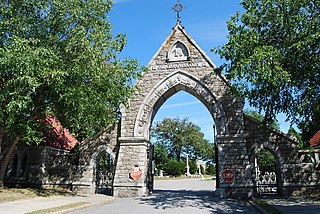
Oak Grove Cemetery is a historic cemetery located at 765 Prospect Street in Fall River, Massachusetts. It was established in 1855 and greatly improved upon in the years that followed. It features Gothic Revival elements, including an elaborate entrance arch constructed of locally quarried Fall River granite. The cemetery originally contained 47 acres, but has since been expanded to over 120 acres. The cemetery is the city's most significant, built in the planned rural-garden style of Mount Auburn Cemetery in Cambridge, Massachusetts. It was designed and laid out by local architect Josiah Brown, who is also known for his designs of early mills including the Union, Border City, and others.
Parsons Boulevard is a road in Queens, New York. Its northern end is at Malba Drive in the Malba neighborhood and its southern end is at Archer Avenue in downtown Jamaica.
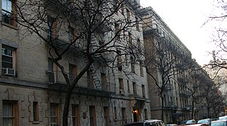
James Edward Ware was an American architect, best known for devising the "dumbbell plan" for New York City tenement housing.

The Jamaica Savings Bank was a bank incorporated in 1866 in the Jamaica section of the borough of Queens in New York City. It had four branches across Queens before it was acquired by North Fork Bank in 1999, which itself was acquired by Capital One Bank in 2008.

Main Street is a major north–south street in the borough of Queens in New York City, extending from Queens Boulevard in Briarwood to Northern Boulevard in Flushing. Created in the 17th century as one of Flushing's main roads, Main Street has been lengthened at various points in its existence.


