Nanango Weir

Last updated

Nanango Weir
Dusk at the weir Nanango Weir.jpeg
Dusk at the weir
Australia Queensland relief location map.jpg
Red pog.svg
Nanango Weir
Location9.6 km (6 mi) North West of Nanango, Queensland
Coordinates 26°39′01″S151°55′28″E / 26.650182°S 151.924437°E / -26.650182; 151.924437 Coordinates: 26°39′01″S151°55′28″E / 26.650182°S 151.924437°E / -26.650182; 151.924437
Type Weir
Primary inflows Barkers Creek
Primary outflows Barkers Creek
Basin  countriesAustralia

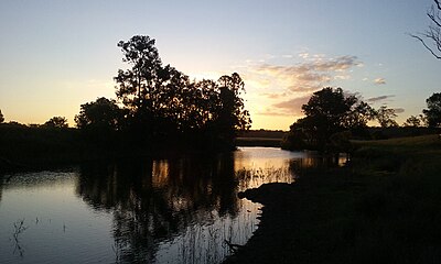
Nanango Weir is a weir located near Nanango, Queensland, Australia. It was originally constructed only used by nearby farms for agricultural use, though public recreation is now permitted.

Contents

The weir is located on Barkers Creek.

Recreation

The weir is widely unknown to the public because of its unsigned location and small access track. The weir is a great spot for canoeing, picnics and other watersports. There is no constructed boat ramps and large vessels or motors are highly discouraged. The weir is usually full though long dry periods can affect water levels.

See also

Related Research Articles

Burnett Highway

The Burnett Highway is an inland rural highway located in Queensland, Australia. The highway runs between its junction with the Bruce Highway just south of Rockhampton, and Nanango. Its length is approximately 542 kilometres. The highway takes its name from the Burnett River, which it crosses in Gayndah. The Burnett Highway provides the most direct link between the northern end of the New England Highway and Rockhampton. It is designated as a State Strategic Road by the Queensland Government.

Nanango Town in Queensland, Australia

Nanango is a town and locality in the South Burnett Region of Queensland, Australia. In the 2016 census, Nanango had a population of 3,599 people.

Electoral district of Nanango

Nanango is an electoral division in the state of Queensland, Australia. Notable towns include Nanango, Kingaroy and Crows Nest.

Shire of Wondai Local government area in Queensland, Australia

The Shire of Wondai was a local government area located in the South Burnett region of Queensland, Australia, about 140 kilometres (87 mi) northwest of the capital, Brisbane. The shire covered an area of 3,577.6 square kilometres (1,381.3 sq mi), and existed as a local government entity from 1910 until 2008, when it amalgamated with several other councils in the South Burnett area to form the South Burnett Region.

Ross River (Queensland)

The Ross River is a river located in northern Queensland, Australia. The 49-kilometre (30 mi) long river flows through the city of Townsville and empties into the Coral Sea. It is the major waterway flowing through Townsville and the city's main source of drinking water.

Shire of Kingaroy Local government area in Queensland, Australia

The Shire of Kingaroy was a local government area in the South Burnett region of Queensland, Australia, about 100 kilometres (62 mi) northwest of the capital, Brisbane. The shire covered an area of 2,420.3 square kilometres (934.5 sq mi), and existed as a local government entity from 1912 until 2008, when it amalgamated with several other councils in the South Burnett area to become the South Burnett Regional Council.

Shire of Nanango Local government area in Queensland, Australia

The Shire of Nanango was a local government area located in the South Burnett region of Queensland, Australia, about 100 kilometres (62 mi) northwest of the capital, Brisbane. The Shire covered an area of 1,738.4 square kilometres (671.2 sq mi), and existed as a local government entity from 1879 until 2008, when it amalgamated with several other councils in the South Burnett area to become the South Burnett Regional Council.

McCauley Weir

McCauley Weir is a weir located near Nanango, Queensland, Australia. It was originally constructed as a water supply for Nanango. It has since ceased to be used as a water supply and is only used by nearby farms for stock use.

Aitkenvale Aerodrome was an aerodrome located 10 km (6 mi) southwest of Townsville, Queensland, Australia near Aitkenvale Weir on the banks of the Ross River. It was also known as Weir and Aitkenvale Weir.

Barambah was an electoral district of the Legislative Assembly in the Australian state of Queensland from 1950 to 2001.

Tingoora Town in Queensland, Australia

Tingoora is a rural town and a locality in the South Burnett Region, Queensland, Australia. In the 2016 census, Tingoora had a population of 273 people.

Woolooga Town in Queensland, Australia

Woolooga is a town and locality in the Wide Bay region of Queensland, Australia. The town is located in the Gympie Region local government area, 221 kilometres (137 mi) north of the state capital, Brisbane.

Nanango railway line

The Nanango railway line was a narrow-gauge branch railway located in Queensland, Australia. On 31 October 1882, parliament approved the construction of a branch line from Theebine west to Kilkivan after gold and copper were discovered in this region of Queensland, Australia. The section was opened in two stages – to Dickabram on 1 January 1886 after two crossings of the Mary River and to Kilkivan on 6 December 1886.

Tarong, Queensland Suburb of South Burnett Region, Queensland, Australia

Tarong is a rural locality in the South Burnett Region, Queensland, Australia.

Murgon Weir

Murgon Weir is a weir located near Murgon, Queensland, Australia. It was originally constructed only used by nearby farms for agricultural use, though public recreation is also permitted.

Nanango Court House

Nanango Court House is a heritage-listed courthouse at 30 Henry Street, Nanango, South Burnett Region, Queensland, Australia. It was designed by Department of Public Works (Queensland) and built in 1937. It was added to the Queensland Heritage Register on 13 January 1995.

South Nanango Suburb of South Burnett Region, Queensland, Australia

South Nanango is a locality in the South Burnett Region, Queensland, Australia.

East Nanango, Queensland Suburb of South Burnett Region, Queensland, Australia

East Nanango is a rural locality in the South Burnett Region, Queensland, Australia. In the 2016 census, East Nanango had a population of 265 people.

South East Nanango, Queensland Suburb of South Burnett Region, Queensland, Australia

South East Nanango is a rural locality in the South Burnett Region, Queensland, Australia. In the 2016 census, South East Nanango had a population of 294 people.

References