This is intended to be a complete list of the properties and districts on the National Register of Historic Places in Henrico County, Virginia, United States. The locations of National Register properties and districts for which the latitude and longitude coordinates are included below, may be seen in an online map.[1]
There are 34 properties and districts listed on the National Register in the county, including 1 National Historic Landmark.
A marker for the Jefferson Davis Highway, conceived and marked by the United Daughters of the Confederacy, as a counter to the Lincoln Highway in the north, during 1913-1925 in an era of named highway promotion, before numbered U.S. highways were created.[7]
Plantation operated continuously as a working farm since 1635. One of the great James River Plantations. Incidentally, site of an airliner's crash-landing in 1951. Plantation house and 156 acres (0.63km2) are NRHP-listed.[9]
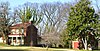
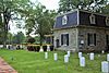
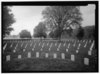
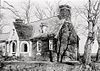
Site of bloody Battle of Malvern Hill on July 1, 1862. Cruciform-plan house built in 1600s, burned in 1905. Ruins, including end gables and chimney still "perhaps the finest example of seventeenth century diaper brickwork in the state."[13]
Home economics building of the Virginia Randolph Training School, a vocational school, where Virginia E. Randolph (1874–1958), who was a black woman, was a teacher and a teacher educator for 55 years. Now a museum commemorating her life. Her gravesite is on the grounds.[14]
International Style building complex set in a composed landscape, completed in 1958, cited as a prototype for modern suburban office development, and featuring aluminum inside and out.[15]
Malvern Hill stands on the north bank of the James River in Henrico County, Virginia, USA, about eighteen miles southeast of Richmond. On 1 July 1862, it was the scene of the Battle of Malvern Hill, one of the Seven Days Battles of the American Civil War.
This is intended to be a complete list of the properties and districts on the National Register of Historic Places in Fairfield County, Connecticut, United States. The locations of National Register properties and districts for which the latitude and longitude coordinates are included below may be seen in an online map.
This is a list of the National Register of Historic Places listings in Litchfield County, Connecticut.
The National Register of Historic Places listings in Syracuse, New York are described below. There are 119 listed properties and districts in the city of Syracuse, including 19 business or public buildings, 13 historic districts, 6 churches, four school or university buildings, three parks, six apartment buildings, and 43 houses. Twenty-nine of the listed houses were designed by architect Ward Wellington Ward; 25 of these were listed as a group in 1996.
This is a list of the National Register of Historic Places listings in Fairfax County, Virginia.
This is a list of the National Register of Historic Places listings in Caroline County, Virginia.
This is a list of the National Register of Historic Places listings in Charles City County, Virginia.
This is a list of the National Register of Historic Places listings in Pittsylvania County, Virginia.
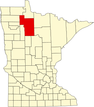
This is a list of the National Register of Historic Places listings in Douglas County, Minnesota. It is intended to be a complete list of the properties and districts on the National Register of Historic Places in Douglas County, Minnesota, United States. The locations of National Register properties and districts for which the latitude and longitude coordinates are included below, may be seen in an online map.
This is a list of the National Register of Historic Places listings in King William County, Virginia.
This is a list of the National Register of Historic Places listings in Prince William County, Virginia.
This is a list of the National Register of Historic Places listings in York County, Virginia.
This is a list of National Register of Historic Places listings in New Haven, Connecticut.
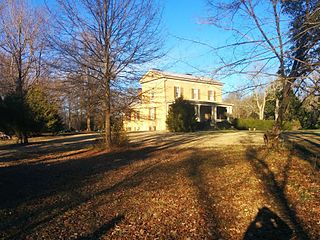
Redesdale in Henrico County, Virginia near Richmond, Virginia was built in 1925. It was listed on the National Register of Historic Places in 2008. The listing included a 35-acre (14 ha) area with 4 contributing buildings, 3 contributing sites and 3 contributing structures.
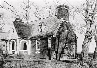
The Clarke–Palmore House, also known as Clarke Home, was built as a brick farmhouse in 1819 and expanded in 1855. Its first floor level, built in 1819, is described as being American bond brickwork of 3 to 5 stretcher courses between each header course. Its upper level, built in 1855, is of American bond with 6 to 7 stretcher courses between each header course.
The Flood Marker of 1771 is a monument that marks the high point of a flood of the James River on May 27, 1771, that killed around 150 people near Richmond, Virginia. The river reached a flood stage of around 45 feet (14 m) above its normal levels.
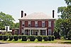
Woodside, near Tuckahoe, Virginia in Henrico County, Virginia, was built in 1858. It is a Greek Revival style villa, in the countryside but not a farmhouse. It was a family home of the Wickham family of Richmond. It was listed on the National Register of Historic Places in 1973.
This is a list of the National Register of Historic Places listings in Beltrami County, Minnesota. This is intended to be a complete list of the properties and districts on the National Register of Historic Places in Beltrami County, Minnesota, United States. The locations of National Register properties and districts for which the latitude and longitude coordinates are included below, may be seen in an online map.
This is a list of the National Register of Historic Places listings in Martin County, Minnesota. It is intended to be a complete list of the properties and districts on the National Register of Historic Places in Martin County, Minnesota, United States. The locations of National Register properties and districts for which the latitude and longitude coordinates are included below, may be seen in an online map.
References
↑ The latitude and longitude information provided in this table was derived originally from the National Register Information System, which has been found to be fairly accurate for about 99% of listings. Some locations in this table may have been corrected to current GPS standards.
↑ Numbers represent an alphabetical ordering by significant words. Various colorings, defined here, differentiate National Historic Landmarks and historic districts from other NRHP buildings, structures, sites or objects.
↑ The eight-digit number below each date is the number assigned to each location in the National Register Information System database, which can be viewed by clicking the number.
This page is based on this Wikipedia article Text is available under the CC BY-SA 4.0 license; additional terms may apply. Images, videos and audio are available under their respective licenses.