Related Research Articles

Route 35 is a state highway in the U.S. state of New Jersey, primarily traveling through the easternmost parts of Middlesex, Monmouth, and Ocean counties. It runs 58.11 mi (93.52 km) from the entrance to Island Beach State Park in Berkeley Township, Ocean County to an intersection with Route 27 in Rahway, Union County. Between Seaside Park and Mantoloking, Route 35 follows the right-of-way of the former Pennsylvania Railroad along the Jersey Shore. The route heads through Point Pleasant Beach and crosses the Manasquan River on the Brielle Bridge, meeting Route 34 and Route 70 at the former Brielle Circle in Wall Township. From there, Route 35 heads north and intersects Route 138, an extension of Interstate 195, continuing north through Monmouth County before crossing the Victory Bridge over the Raritan River into Perth Amboy, where the route continues north to Rahway.

Middlesex County is located in the north-central part of New Jersey, United States, extending inland from the Raritan Valley region to the northern portion of the Jersey Shore. As of the 2020 United States census, the county was the state's third-most populous county with a population of 863,162, its highest decennial count ever and an increase of 53,304 (+6.6%) from the 2010 census count of 809,858, which in turn reflected an increase of 59,696 (8.0%) from the 750,162 counted in the 2000 census. Middlesex is part of the New York metropolitan area. Many communities within the county serve as commuter towns to and from New York City and other points north. The county is part of the Central Jersey region of the state.

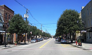
Perth Amboy is a city situated on the Jersey Shore in northeastern Middlesex County, in the U.S. state of New Jersey, within the New York metropolitan area. As of the 2020 United States census, the city's population was 55,436, its highest decennial count ever and an increase of 4,622 (+9.1%) from the 50,814 recorded at the 2010 census, which in turn had reflected an increase of 3,511 (+7.4%) from the 47,303 counted at the 2000 census. Perth Amboy has a Hispanic majority population. In the 2010 census, the Hispanic population made up 78.1% of the population, the second-highest in the state, behind Union City at 84.7%. Perth Amboy is known as the "City by the Bay", referring to its location adjoining Raritan Bay. The Census Bureau's Population Estimates Program calculated that the city's population was 55,357 in 2021, ranking the city as the 725th-most-populous in the country.
South Amboy is a suburban city in Middlesex County, in the U.S. state of New Jersey, located on Raritan Bay. As of the 2020 United States census, the city's population was 9,411, an increase of 780 (+9.0%) from the 2010 census count of 8,631, which in turn reflected an increase of 718 (+9.1%) from the 7,913 counted in the 2000 census.

The Raritan River is a major river of New Jersey. Its watershed drains much of the mountainous area of the central part of the state, emptying into the Raritan Bay on the Atlantic Ocean.
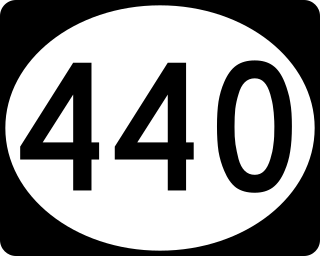
Route 440 is a state highway in New Jersey, United States. It comprises two segments, a 5.15-mile (8.29 km) freeway in Middlesex County linking Interstate 287 (I-287) and the New Jersey Turnpike (I-95), in Edison to the Outerbridge Crossing in Perth Amboy and an 8.18-mile (13.16 km) four-lane divided highway in Hudson County running from the Bayonne Bridge in Bayonne to U.S. Route 1/9 Truck in Jersey City. These two segments are connected by New York State Route 440 (NY 440), which runs across Staten Island. The freeway portion in Middlesex County is six lanes wide and interchanges with the Garden State Parkway and US 9 in Woodbridge.

The Jersey Shore is the coastal region of the U.S. state of New Jersey. Geographically, the term encompasses about 141 miles (227 km) of oceanfront bordering the Atlantic Ocean, from Perth Amboy in the north to Cape May Point in the south. The region includes Middlesex, Monmouth, Ocean, Atlantic, and Cape May counties, which are in the central and southern parts of the state. Located in the center of the Northeast Megalopolis, the northern half of the shore region is part of the New York metropolitan area, while the southern half of the shore region is part of the Philadelphia metropolitan area, also known as the Delaware Valley. The Jersey Shore hosts the highest concentration of oceanside boardwalks in the United States.

The Newark–Trenton Fast Line was an interurban line from Newark, New Jersey to Trenton, New Jersey via Elizabeth and New Brunswick. It was owned and operated by the Public Service Railroad, a subsidiary of the Public Service Corporation of New Jersey.
The Jersey Central Traction Company was a streetcar company in central New Jersey, with its main lines from Red Bank and Highlands to Perth Amboy.

Division Street is a major east-west street in Chicago, Illinois, located at 1200 North. Division Street begins in the Gold Coast neighborhood near Lake Shore Drive, passes through Polonia Triangle at Milwaukee Avenue into Wicker Park and continues to Chicago's city limits and into the city's western suburbs. Once known as "Polish Broadway" during the heyday of Polish Downtown, Division Street was the favorite street of author Nelson Algren. A fountain dedicated in his name was installed in what had been the area that figured as the inspiration for much of his work.

Dominican Americans are Americans who trace their ancestry to the Dominican Republic. The word may refer to someone born in the United States of Dominican descent or to someone who has migrated to the United States from the Dominican Republic. As of 2021, there were approximately 2.4 million people of Dominican descent in the United States, including both native and foreign-born. They are the second largest Hispanic group in the Northeastern region of the United States after Puerto Ricans, and the fifth-largest Hispanic/Latino group nationwide.

Fairhill is a neighborhood on the east side of the North Philadelphia section of Philadelphia, Pennsylvania, United States. Fairhill is bordered by Front Street to the east, Germantown Avenue to the west, Allegheny Avenue to the north, and Cumberland Street to the south. The neighborhood serves as the center of the Hispanic community of Philadelphia, and is known for its "El Centro de Oro" commercial strip along North 5th Street. Fairhill is adjacent to Harrowgate and West Kensington to the east, Hartranft to the south, Glenwood to the west, and Hunting Park to the north.
Harrowgate is a neighborhood in the River Wards section of Philadelphia, Pennsylvania, United States, located immediately northeast of Kensington adjacent to Kensington Avenue. It is bordered by Feltonville, Juniata and Frankford to the north, Fairhill to the west, West Kensington and Kensington to the south, and Port Richmond and Bridesburg to the east.

The Raritan Bayshore is a region in central sections in the state of New Jersey. It is the area around Raritan Bay from The Amboys to Sandy Hook, in Middlesex and Monmouth counties, including the towns of Perth Amboy, South Amboy, Sayreville, Old Bridge, Matawan, Aberdeen, Keyport, Union Beach, Hazlet, Keansburg, Middletown, Atlantic Highlands, and Highlands. It is the northernmost part of the Jersey Shore, located just south of New York City. At Keansburg is a traditional amusement park while at Sandy Hook are found ocean beaches. The Sadowski Parkway beach area in Perth Amboy, which lies at the mouth of the Raritan River, was deemed the "Riviera of New Jersey" by local government. In recent years many of the beaches on the Bayshore area have been rediscovered and upgraded.

Perth Amboy is a station on NJ Transit's North Jersey Coast Line, located in Perth Amboy, New Jersey. The station is located in a cut between Elm Street and Maple Street and between Smith Street and Market Street in downtown Perth Amboy, and has two low side platforms.

Since its founding in 1625 by Dutch traders as New Amsterdam, New York City has been a major destination for immigrants of many nationalities who have formed ethnic enclaves, neighborhoods dominated by one ethnicity. Freed African American slaves also moved to New York City in the Great Migration and the later Second Great Migration and formed ethnic enclaves. These neighborhoods are set apart from the main city by differences such as food, goods for sale, or even language. Ethnic enclaves provide inhabitants security in work and social opportunities, but limit economic opportunities, do not encourage the development of English speaking, and keep immigrants in their own culture.
The U.S. state of New Jersey is home to significant and growing numbers of people of Hispanic and Latino descent, who in 2018 represented a Census-estimated 20.4% of the state's total population. New Jersey's Latino population comprises substantial concentrations of Dominican Americans, Puerto Rican Americans, Cuban Americans, Mexican Americans, Central Americans, Peruvian Americans, Colombian Americans, and Ecuadorian Americans. New Jersey is also home to a large Brazilian American and Portuguese-speaking population.
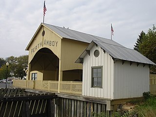
The Perth Amboy Ferry Slip, located on the Arthur Kill in Perth Amboy, Middlesex County, New Jersey, United States, was once a vital ferry slip for boats in New York Harbor. It was added to the New Jersey Register of Historic Places and National Register of Historic Places in 1978. The ferry slip was restored in 1998 to its 1904 appearance. A replica of the ticket office has been constructed and is used as a small museum.

Philadelphia has the second largest Puerto Rican community outside of Puerto Rico after New York City. As of the 2010 U.S. Census, an estimated 121,643 Puerto Ricans were living in Philadelphia, up from 91,527 in 2000. Recent 2017 estimates by the U.S. Census Bureau put the number of Puerto Ricans living in Philadelphia at 134,934. In 2019, estimates put the number of Puerto Ricans at 146,153. Many Puerto Ricans in the Philadelphia area have engaged in circular migration in which they spend periods of time living in Philadelphia and periods of time living in Puerto Rico.
References
- ↑ "Archived copy" (PDF). Archived from the original (PDF) on March 4, 2016. Retrieved May 6, 2015.
{{cite web}}: CS1 maint: archived copy as title (link) - ↑ Silverstein, Marilyn. "Rabbi hopes to bring renaissance to shul" Archived 2012-02-22 at the Wayback Machine , New Jersey Jewish News , June 17, 2004, accessed April 11, 2007. "Once upon a time, Perth Amboy was the hub of a thriving Jewish community, observed Rabbi Israel Einhorn. “Perth Amboy used to be the No. 1 shtetl in New Jersey. They had butchers, bakers, yeshivas,” Einhorn said as he sat in his office at Congregation Shaarey Tefiloh, an Orthodox shul on the waterfront in the economically depressed town."
- ↑ Paul W. Wang, Katherine A. Massopust - 2009 Perth Amboy - Page 13 0738562416 "It is best known as "the five corners" because one can go in five different directions from this point in Perth Amboy. (Historic image courtesy of Jack M. Dudas Esq.) Shown is upper Smith Street in the late 1930s "
- ↑ "New Jersey Postal History Society".
- ↑ "Maurer neighborhood in Perth Amboy, New Jersey (NJ), 08861 subdivision profile - real estate, apartments, condos, homes, community, population, jobs, income, streets".
