
Cohoes is an incorporated city located in the northeast corner of Albany County in the U.S. state of New York. It is called the "Spindle City" because of the importance of textile manufacturing to its growth in the 19th century. The city's factories processed cotton from the Deep South.

The Russell Company Upper Mill is an historic structure in Middletown, Connecticut, at the junction of Russell Street and East Main Street in South Farms, at the end of East Main Street's commercial and industrial development areas. Built in 1836, it is listed on the National Register of Historic Places. There is a small pond to the south. Small businesses border the street to the north, followed by the buildings of Russell Manufacturing Company, the area's most dominant feature. Russell Street crosses Sumner Brook nearby and ascends to a large residential district to the west. The mill is currently a condo-apartment complex.

Harmony Mills, in Cohoes, New York, United States, is an industrial district that is bordered by the Mohawk River and the tracks of the former Troy and Schenectady Railroad. It was listed as Harmony Mills Historic District on the National Register of Historic Places in 1978. A portion of the district encompassing the industrial buildings and some of the housing built for millworkers was declared a National Historic Landmark in 1999. The centerpiece building, Harmony Mill No. 3 was listed on the National Register of Historic Places in 1971.

The Lord & Burnham Building, located at the corner of Main and Astor Streets in Irvington, New York, United States, is a brick building in the Queen Anne architectural style built in the 1880s. In 1999 it was listed on the National Register of Historic Places, and was added as a contributing property to the Irvington Historic District in 2014.
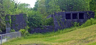
Lock 18 of the Enlarged Erie Canal is located off North Mohawk Street in Cohoes, New York, United States. It is made of stone blocks 3 by 2 by 1.5 feet in size, roughly 150 feet (46 m) in length, laid in a random ashlar pattern. The lock's wooden gates are no longer extant.

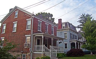
The Downtown Cohoes Historic District takes up 35 acres (14 ha) of the city of Cohoes, New York, United States. Many of the 165 contributing properties date from the 1820-1930 period when the Erie Canal and Harmony Mills were the mainstay of the city's economy. It was recognized as a historic district and added to the National Register of Historic Places in 1984. After years of neglect and decline, it has recently started to see an upswing in business activity due to its historic character and the city's efforts to protect it.
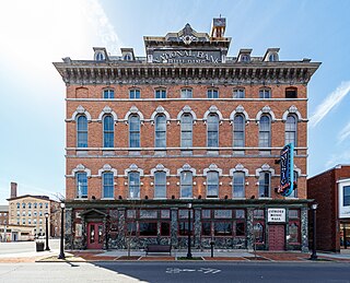
Cohoes Music Hall is a vintage music hall located at 58 Remsen Street in Cohoes, New York, United States. It is a four-story brick building in the Second Empire architectural style. Built in 1874, it is considered the best example of that style in the city, with an unusually decorative front facade.
The Stone Street Historic District is a one-block section of the west side of that street in the hamlet of New Hamburg, New York, United States. It was recognized as a historic district and added to the National Register of Historic Places in 1987 as the largest group of intact houses in the hamlet.
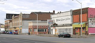
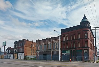
The Jefferson–Chalmers Historic Business District is a neighborhood located on East Jefferson Avenue between Eastlawn Street and Alter Road in Detroit, Michigan. The district is the only continuously intact commercial district remaining along East Jefferson Avenue, and was listed on the National Register of Historic Places in 2004.

The Lake Linden Historic District is located in the village of Lake Linden in Houghton County, Michigan.

The U.S. Post Office in Medina, New York, is located at West Avenue and West Center Street. It is a brick building erected in the early 1930s, serving the ZIP Code 14103, covering the village of Medina and neighboring portions of the towns of Ridgeway and Shelby.

The Arbor Hill Historic District–Ten Broeck Triangle, originally the Ten Broeck Historic District, is a seven-block area located within the Arbor Hill neighborhood north of what is today downtown Albany, New York, United States. In 1979 its easternmost third, the Ten Broeck Triangle, the second oldest residential neighborhood in the city, was recognized as a historic district and listed on the National Register of Historic Places. Four years later, the district was increased to its current size and renamed to reflect its expansion to include some of the rest of Arbor Hill.

The Broadway–Livingston Avenue Historic District is located at the junction of those two streets in Albany, New York, United States. It includes seven buildings remaining from an original 20, all contributing properties, and a Warren truss railroad bridge. In 1988 the area was recognized as a historic district and listed on the National Register of Historic Places.

The Knox Street Historic District is primarily located along one block of that street in the Park South neighborhood of Albany, New York, United States. Its contributing properties are several groups of attached rowhouses. The area was recognized as a historic district and listed on the National Register of Historic Places in 2008.
St. John Chrysostom's Church is a Roman Catholic parish church under the authority of the Roman Catholic Archdiocese of New York, in the Morrisania section of the New York City borough of the Bronx.

The Bank Street Historic District is a group of four attached brick commercial buildings in different architectural styles on that street in Waterbury, Connecticut, United States. They were built over a 20-year period around the end of the 19th century, when Waterbury was a prosperous, growing industrial center. In 1983 they were recognized as a historic district and listed on the National Register of Historic Places.
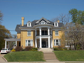
The Selma Schricker House is a historic building located in a residential neighborhood in the West End of Davenport, Iowa, United States. At one time the house served as the official residence of Davenport's Catholic bishop. It is a contributing property in the Riverview Terrace Historic District. The district was added to the National Register of Historic Places in 1984.

The former Albany Felt Company Complex, now The Lofts at One Broadway, is located along Broadway in eastern Albany County, New York, United States. It is mostly within the village of Menands, with a small portion at its southern end within the city of Albany. In 2014 it was listed on the National Register of Historic Places.
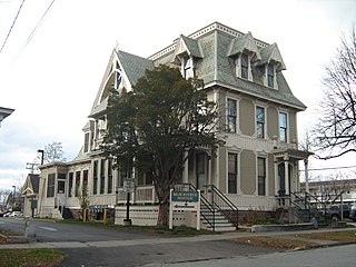
The Martin L. Kelsey House is a historic house at 43 Elmwood Avenue in Burlington, Vermont. Built in 1879 for a local merchant, it is a distinctive and architecturally varied house, with elements of the Second Empire, Queen Anne, and Stick styles on display. It was listed on the National Register of Historic Places in 1983, and now forms part of a senior housing complex.
The Michigan Avenue Historic Commercial District in Detroit is a group of commercial buildings located along the south side of two blocks of Michigan Avenue, from 3301–3461. This section of buildings is the most intact collection along this stretch of Detroit's Michigan Avenue. The district was listed on the National Register of Historic Places in 2020.


