Outline of Andhra Pradesh

Last updated

Geography of Andhra Pradesh IN-AP.svg
Geography of Andhra Pradesh

The following outline is provided as an overview of and topical guide to Andhra Pradesh:

Contents

Andhra Pradesh one of the 28 states of India, situated on the southeastern coast of the country. It is the seventh-largest state with area of 162,970 km2 (62,920 sq mi) [1] and tenth-most-populous state with 49,577,103 inhabitants as per 2011 census of India. On 2 June 2014, the north-western portion of the state was bifurcated to form a new state of Telangana. In accordance with the Andhra Pradesh Reorganisation Act, 2014.Amaravati serves as the capital of the state with the largest city being Visakhapatnam. Telugu, used by majority of people and is the official language along with English.

General reference

Names

Rankings (amongst India's states)

Geography of Andhra Pradesh

Topographic map of Andhra Pradesh Andhra Pradesh topo leer.png
Topographic map of Andhra Pradesh

Geography of Andhra Pradesh

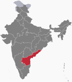
Location of Andhra Pradesh

Places in Andhra Pradesh

Places in Andhra Pradesh

Environment of Andhra Pradesh

Geographic features of Andhra Pradesh

Protected areas of Andhra Pradesh

Regions of Andhra Pradesh

Administrative divisions

Districts of Andhra Pradesh
Andhra Pradesh political map Andhra Pradesh districts 2022.svg
Andhra Pradesh political map

Districts of Andhra Pradesh Andhra Pradesh is subdivided into 26 districts

Mandals of Andhra Pradesh
Municipalities of Andhra Pradesh

Demographics of Andhra Pradesh

Demographics of Andhra Pradesh

Government and politics of Andhra Pradesh

Politics of Andhra Pradesh

Elections in Andhra Pradesh

Elections in Andhra Pradesh

Union government in Andhra Pradesh

Branches of the government of Andhra Pradesh

Government of Andhra Pradesh

Executive branch

Legislative branch

Andhra Pradesh Legislature

Judicial branch

Law and order in Andhra Pradesh

History of Andhra Pradesh

History of Andhra Pradesh

History of Andhra Pradesh, by period

Prehistoric Andhra Pradesh

Ancient Andhra Pradesh

Medieval Andhra Pradesh

Colonial Andhra Pradesh

Contemporary Andhra Pradesh

History of Andhra Pradesh, by region

History of Andhra Pradesh, by subject

Culture of Andhra Pradesh

Rock-cut Lord --Buddha-- Statue at Bojjanakonda near Anakapalle of Visakhapatnam dist in AP.jpg
Rock cut Buddha Statue at Bojjanakonda
Kondapalli toys at a house in Vijayawada.jpg
Kondapalli toys at a house in Vijayawada
Yamini Reddy kuchipudi.jpg
A Kuchipudi performance
Vegetarian Andhra Meal.jpg
A Vegetarian Andhra Meal platter

Culture of Andhra Pradesh

The arts in Andhra Pradesh

Architecture in Andhra Pradesh

Dance in Andhra Pradesh

Literature of Andhra Pradesh

Telugu literature

Music of Andhra Pradesh

Music of Andhra Pradesh

Cuisine of Andhra Pradesh

Cuisine of Andhra Pradesh

Festivals in Andhra Pradesh

People of Andhra Pradesh

Religion in Andhra Pradesh

Religion in Andhra Pradesh (2011)

   Hinduism (90.89%)
   Islam (7.30%)
   Christianity (1.38%)
   Jainism (0.05%)
   Sikhism (0.02%)
   Buddhism (0.01%)
  Other (0.01%)
  Not Stated (0.34%)

Religion in Andhra Pradesh

Sports in Andhra Pradesh

Sports in Andhra Pradesh

Symbols of Andhra Pradesh

Symbols of Andhra Pradesh

Economy and infrastructure of Andhra Pradesh

Economy of Andhra Pradesh

Education in Andhra Pradesh

Education in Andhra Pradesh

Health and safety in Andhra Pradesh

See also

Related Research Articles

<span class="mw-page-title-main">Andhra Pradesh</span> State in southern India

Andhra Pradesh is a state in the southern coastal region of India. It is the seventh-largest state with an area of 162,970 km2 (62,920 sq mi) and the tenth-most populous state with 49,577,103 inhabitants. It has shared borders with Chhattisgarh, Odisha, Karnataka, Tamil Nadu, Telangana and the Bay of Bengal. It has the second-longest coastline in India at about 974 km (605 mi). After existence as Andhra State and unified Andhra Pradesh, the state took its present form on 2 June 2014, when the new state of Telangana was formed through bifurcation. Amaravati is the capital of the state, with the largest city being Visakhapatnam. Water sharing disputes and asset division with Telangana are not yet resolved. Telugu, one of the classical languages of India used by the majority of people, is the first official language.

<span class="mw-page-title-main">Visakhapatnam</span> Metropolis in Andhra Pradesh, India

Visakhapatnam, also known as Vizag, Viśākha or Waltair, is the largest and most populous metropolitan city in the Indian state of Andhra Pradesh. It is between the Eastern Ghats and the coast of the Bay of Bengal. It is the second largest city on the east coast of India after Chennai, and the fourth-largest in South India. It is one of the four smart cities of Andhra Pradesh selected under the Smart Cities Mission and is the headquarters of Visakhapatnam district. With an estimated output of $43.5 billion, it is the ninth-largest contributor to India's gross domestic product as of 2016.

<span class="mw-page-title-main">Chittoor</span> City in Andhra Pradesh, India

Chittoor is a city and district headquarters in Chittoor district of the Indian state of Andhra Pradesh. It is also the mandal and divisional headquarters of Chittoor mandal and Chittoor revenue division respectively. The city has a population of 153,756 and that of the agglomeration is 175,647.

<span class="mw-page-title-main">Srikakulam</span> Place in Andhra Pradesh, India

Srikakulam is a city and the headquarters of Srikakulam district in the Indian state of Andhra Pradesh. As of 2011 census, it has a population of 165,735. There are many other places of Buddhist Tourism such as Salihundam, Kalinga Patnam, Dabbaka Vaani Peta, Nagari Peta, Jagati Metta, Singupuram etc. in Srikakulam District. The Buddhist heritage site of Salihundam has some unique features. It has a beautiful star atop a stupa, rock cut massive stupas inside chaitya grihas, brick stupas with wheel pattern plan, votive stupas, inscriptions on the steps leading to the stupas and museum housing over two dozen sculpted statue and figurines of Buddha, Jain Teerthankars and other deities

<span class="mw-page-title-main">West Godavari district</span> District of Andhra Pradesh in India

The West Godavari district is a coastal district in the Indian state of Andhra Pradesh with an administrative headquarters in Bhimavaram. As of the 2011 Census of India, the district has an area of 2,178 km2 (841 sq mi) and a population of 1,779,935. It is bounded by the Krishna district and Bay of Bengal to the south, East Godavari district to the east, and Eluru district, Kolleru Lake and Upputeru Drain to the northwest.

<span class="mw-page-title-main">Eluru</span> City in Andhra Pradesh, India

Eluru is a city and the district headquarters of Eluru district in the Indian state of Andhra Pradesh. It is one of the 14 municipal corporations in the state and the mandal headquarters of Eluru mandal in the Eluru revenue division. The city is on the Tammileru river. The city is well known for its wool-pile carpets and hand woven products. As of 2011 Census of India, the city had a population of 214,414. Its history dates back to the second century CE.

<span class="mw-page-title-main">Tirupati</span> City in Andhra Pradesh, India

Tirupati is a city in the Indian state of Andhra Pradesh. It is the administrative headquarters of the Tirupati district. The city is home to the important Hindu shrine of Tirumala Venkateshwara Temple and other historic temples. It is located at a distance of 150 km from Chennai, 250 km from Bangalore, 406 km from Amaravati. It is one of the eight Svayam vyakta kshetras dedicated to Vishnu. Tirupati is a municipal corporation and the headquarters of Tirupati (urban) mandal, Tirupati (rural) mandal, and the Tirupati revenue division.

<span class="mw-page-title-main">Nellore district</span> District of Andhra Pradesh in India

Nellore district, officially known as Sri Potti Sriramulu Nellore district in Coastal Andhra Region, is one of the 26 districts in the Indian state of Andhra Pradesh. According to the 2011 Census, the district's population was 2,469,712 of which 29.07% was urban. Its administrative headquarters are located in Nellore city. Located in the Coastal Andhra region, the district is bordered by the Bay of Bengal to the east, Kadapa district and Annamayya district to the west, Prakasam district to the north, and Tirupati district to the south.

<span class="mw-page-title-main">Acharya N. G. Ranga Agricultural University</span> Agricultural university in Andhra Pradesh, India

Acharya N. G. Ranga Agricultural University (ANGRAU) is a public agricultural university with its headquarters at the village Lam, Guntur, Andhra Pradesh, India.

<span class="mw-page-title-main">Parvathipuram, Andhra Pradesh</span> Place in Andhra Pradesh, India

Parvathipuram is a municipality located at Parvathipuram Manyam district of Indian state of Andhra Pradesh. It is the administrative headquarters of Parvathipuram Manyam district and headquarters of Parvathipuram revenue division and Parvathipuram mandal. This revenue division shares a border with various districts in Odisha.

<span class="mw-page-title-main">Tourism in Andhra Pradesh</span> Overview of tourism in Andhra Pradesh, India

Andhra Pradesh is a state in India. Andhra Pradesh Tourism Development Corporation (APTDC) is a state government agency which promotes tourism in Andhra Pradesh, describing the state as the Koh-i-Noor of India. Andhra Pradesh has a variety of tourist attractions including beaches, hills, caves, wildlife, forests and temples.

<span class="mw-page-title-main">Kala Venkata Rao</span> Indian independence activist and politician

Kala Venkata Rao was an Indian independence activist and politician. He served as the Minister for Revenue in the governments of the Madras Presidency and Andhra Pradesh. He also served as the Minister of Finance in the latter.

Nataraja Ramakrishna was an Indian dance guru. He was the chairman of Andhra Pradesh Sangeeta Nataka Academy. He was also a scholar and musicologist who promoted classical dance in Andhra Pradesh and worldwide.

<span class="mw-page-title-main">Uma Rama Rao</span>

K. Uma Rama Rao was an Indian Kuchipudi dancer, choreographer, research scholar, author and dance teacher. She was also the Founder & Director of Lasya Priya Dance Academy, established in 1985 in Hyderabad, India.

<span class="mw-page-title-main">Kolakaluri Enoch</span> Indian writer and educationist

Kolakaluri Enoch is an Indian writer, teacher, and former Vice Chancellor of Sri Venkateswara University, Tirupati. He was honoured by the Government of India, in 2014, by bestowing on him the Padma Shri, the fourth highest civilian award, for his contributions to the field of literature.

<span class="mw-page-title-main">Kodali Nani</span> Indian politician

Kodali Sri Venkateswara Rao, commonly known as Kodali Nani, is an Indian politician and a Member of Legislative Assembly (MLA) of Andhra Pradesh Legislative Assembly, representing Gudivada Assembly constituency. He is a former Minister for Civil Supplies and Consumer Affairs in the state of Andhra Pradesh. He belongs to the YSR Congress Party.

<span class="mw-page-title-main">Tirupati district</span> District in Andhra Pradesh, India

Tirupati district is one of the eight districts of Rayalaseema region in the Indian state of Andhra Pradesh. The district headquarters is located at Tirupati city. This district is known for its numerous historic temples, including the Hindu shrine of Tirumala Venkateswara Temple and Sri Kalahasteeswara temple. The district is also home to Satish Dhawan Space Centre, a rocket launch centre located in Sriharikota. The river Swarnamukhi flows through Tirupati, Srikalahasti and joins the Bay of Bengal.

References

  1. DOP 2023, p. 3.
  2. http://svzoo.org/ Sri Venkateswara National Park

Gnome-globe.svg Wikimedia Atlas of Andhra Pradesh