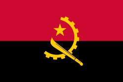
The Flag of Angola
The Emblem of Angola

The following outline is provided as an overview of and topical guide to Angola:
Contents
- General reference
- Geography of Angola
- Location
- Environment of Angola
- Regions of Angola
- Demography of Angola
- Government and politics of Angola
- Branches of the government of Angola
- Foreign relations of Angola
- Law and order in Angola
- Military of Angola
- History of Angola
- History of Angola, by period
- History of Angola, by subject
- Culture of Angola
- Art in Angola
- Sports in Angola
- Economy and infrastructure of Angola
- Education in Angola
- Health in Angola
- See also
- References
- External links
- Government
- Portuguese
- News
- Politics
- Overviews
- Directories
- Other
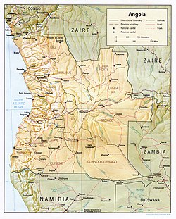
Angola – country in southern Africa bordered by Namibia on the south, the Democratic Republic of the Congo on the north, and Zambia on the east; its west coast is on the Atlantic Ocean with Luanda as its capital city. The exclave province of Cabinda has borders with the Republic of the Congo and the Democratic Republic of the Congo. The country has vast mineral and petroleum reserves, and its economy has on average grown at a two-digit pace since the 1990s, especially since the end of the civil war. In spite of this, standards of living remain low, and life expectancy and infant mortality rates in Angola are among the worst-ranked in the world. [1]


