Greenport is a village in Suffolk County, New York, United States. It is on the north fork of Long Island. The population was 2,197 at the 2010 census.
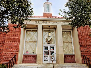
Westhampton Beach is an incorporated village in the Town of Southampton, in Suffolk County, on the South Shore of Long Island, in New York, United States. As of the 2010 census, the population was 1,721.

Greenburgh is a town in the western part of Westchester County, New York. The population was 95,397 at the time of the 2020 census.
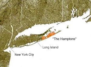
The Hamptons, part of the East End of Long Island, consist of the towns of Southampton and East Hampton, which together comprise the South Fork of Long Island, in Suffolk County, New York. The Hamptons are a popular seaside resort and one of the historical summer colonies of the northeastern United States.

Southampton is a village in Suffolk County, New York, United States. The village is named after the Earl of Southampton. The Village of Southampton is in the southeastern part of the county in the Town of Southampton. The population was 3,109 at the 2010 census.
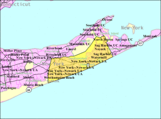
Southampton, officially the Town of Southampton, is a town in southeastern Suffolk County, New York, United States, partly on the South Fork of Long Island. As of the 2020 United States Census, the town had a population of 69,036. Southampton is included in the stretch of shoreline prominently known as The Hamptons.

The Town of East Hampton is located in southeastern Suffolk County, New York, United States, at the eastern end of the South Shore of Long Island. It is the easternmost town in the state of New York. At the time of the 2020 United States Census, it had a total population of 28,385.
New York State Route 27 (NY 27) is a 120.58-mile (194.05 km) long state highway that runs east–west from Interstate 278 (I-278) in the New York City borough of Brooklyn to Montauk Point State Park on Long Island, New York. Its two most prominent components are Sunrise Highway and Montauk Highway, the latter of which includes the Montauk Point State Parkway. NY 27 acts as the primary east–west highway on southern Long Island east of the interchange with the Heckscher State Parkway in Islip Terrace. The entire route in Suffolk, Nassau, and Queens counties were designated by the New York State Senate as the POW/MIA Memorial Highway. The highway gives access to every town on the South Shore. NY 27 is the easternmost state route in the state of New York.

The neighborhoods of Albany, New York are listed below.

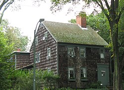
Mulford Farm in East Hampton, Long Island, New York, is one of America's most significant, intact English colonial farmsteads. The farmhouse was built in 1680 by High Sheriff Josiah Hobart, an important early official of the first New York Royal Province government. Samuel "Fish Hook" Mulford bought the property in 1712 after Hobart's death. He had the barn built in 1721. The property is listed as a contributing property of the East Hampton Village District, a historic district listed on the National Register of Historic Places.
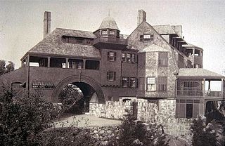
The shingle style is an American architectural style made popular by the rise of the New England school of architecture, which eschewed the highly ornamented patterns of the Eastlake style in Queen Anne architecture. In the shingle style, English influence was combined with the renewed interest in Colonial American architecture which followed the 1876 celebration of the Centennial. The plain, shingled surfaces of colonial buildings were adopted, and their massing emulated.

Hayground Windmill is an historic windmill at Windmill Lane in East Hampton Village, New York. It was moved from Hayground to Pantigo between Two Mile Hollow Beach and Egypt Beach in the 1950s.

East Hampton Village District is a historic district in East Hampton, New York.

The Amherst Village Historic District encompasses the historic village center of Amherst, New Hampshire. Centered on the town's common, which was established about 1755, Amherst Village is one of the best examples of a late-18th to early-19th century New England village center. It is roughly bounded on the north by Foundry Street and on the south by Amherst Street, although it extends along some roads beyond both. The western boundary is roughly Davis Lane, the eastern is Mack Hill Road, Old Manchester Road, and Court House Road. The district includes the Congregational Church, built c. 1771-74, and is predominantly residential, with a large number of Georgian, Federal, and Greek Revival houses. Other notable non-residential buildings include the Farmer's Bank, a Federal-style brick building built in 1806, and the Amherst Brick School, a brick Greek Revival structure that has served as the School Administrative Unit 39 offices since 1997.

The Jewell Town District of South Hampton, New Hampshire, encompasses a colonial-era industrial village with a history dating to 1687. It is centered at the junction of West Whitehall and Jewell Streets, which is just south of a bend in the Powwow River, the source of the power for the mills that were built here. The area was settled in 1687 by Thomas Jewell, and by the early 19th century included a variety of mills as well as a bog iron works. The district now includes only remnants of its industrial past, and features a collection of 18th and early-19th century residential architecture. The district was listed on the National Register of Historic Places in 1983.

Readingsburg, also known as Stone Mill, is an unincorporated community located along the South Branch Raritan River within Clinton Township in Hunterdon County, New Jersey.
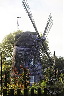
The Pantigo Windmill on James Lane in Easthampton, New York is a smock mill with eight sides, bearing a weathervane on top with 1771 punched through it. The structure was added to the National Register of Historic Places in 1984 as a contributing property of the East Hampton Village District.

The Quogue Historic District is an area of historic residences in Quogue on the East End of Long Island, New York. The historic houses include structures that date from the 18th, 19th and early 20th centuries and retain their architectural and historic integrity. The district was listed in the National Register of Historic Places as a historic district in 2016.