Route 35 is a state highway in the U.S. state of New Jersey, primarily traveling through the easternmost parts of Middlesex, Monmouth, and Ocean counties. It runs 58.11 mi (93.52 km) from the entrance to Island Beach State Park in Berkeley Township, Ocean County to an intersection with Route 27 in Rahway, Union County. Between Seaside Park and Mantoloking, Route 35 follows the right-of-way of the former Pennsylvania Railroad along the Jersey Shore. The route heads through Point Pleasant Beach and crosses the Manasquan River on the Brielle Bridge, meeting Route 34 and Route 70 at the former Brielle Circle in Wall Township. From there, Route 35 heads north and intersects Route 138, an extension of Interstate 195, continuing north through Monmouth County before crossing the Victory Bridge over the Raritan River into Perth Amboy, has where the route continues north to Rahway.

Ewing Township is a township in Mercer County, New Jersey, United States. The township is within the New York metropolitan area as defined by the United States Census Bureau. It also directly borders the Philadelphia metropolitan area and is part of the Federal Communications Commission's Philadelphia Designated Market Area. As of the 2010 United States Census, the township's population was 35,790, reflecting an increase of 83 (+0.2%) from the 35,707 counted in the 2000 Census, which had increased by 1,522 (+4.5%) from the 34,185 counted in the 1990 Census.
Route 71 is a state highway in New Jersey, United States, running 16.78 miles (27.00 km) near the shore in Monmouth County. It begins at Route 35 in Brielle, just north of the Manasquan River and the Ocean County line, and heads north to Route 35 in Eatontown, with a four-block concurrency with Route 35 in Belmar. Monmouth University is located off Route 71 in West Long Branch.
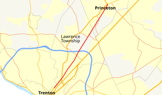
County Route 583, abbreviated CR 583, is a county highway in the U.S. state of New Jersey. Its northern end is at an intersection with Route 27 in Princeton; its southern end is in a concurrency with U.S. Route 1 Business and U.S. Route 206 at an intersection with County Route 653 in Trenton.

Prospect Heights is a neighborhood in the northwest of the New York City borough of Brooklyn. The traditional boundaries are Flatbush Avenue to the west, Atlantic Avenue to the north, Eastern Parkway – beginning at Grand Army Plaza – to the south, and Washington Avenue to the east. In the northern section of Prospect Heights are the Vanderbilt Rail Yards, built over as part of the Pacific Park project. The Barclays Center, home to the NBA's Brooklyn Nets basketball team and part-time home to the NHL's New York Islanders ice hockey team, is located in the northwestern corner of the neighborhood in Pacific Park at Flatbush and Atlantic Avenues.

North Trenton is a neighborhood located within the city of Trenton in Mercer County, New Jersey, United States.
Interstate 95 (I-95) is an Interstate highway running from Miami, Florida, north to Houlton, Maine. In the U.S. state of Pennsylvania, it runs 44.25 miles (71.21 km) from the Delaware state line near Marcus Hook to the Delaware River–Turnpike Toll Bridge at the New Jersey state line. From the Delaware state line to exit 40, the route is known by many as the Delaware Expressway, but is officially named the Vietnam Veterans Memorial Highway. North(east) of exit 40, I-95 runs along the easternmost portion of the Pennsylvania Turnpike. I-95 parallels its namesake Delaware River for its entire route through the city of Philadelphia and its suburbs. It is a major route through the city and the metropolitan Delaware Valley, providing access to locally important landmarks such as Philadelphia International Airport, the South Philadelphia Sports Complex, Talen Energy Stadium, Penn's Landing, and Philadelphia Mills. Of the 15 states that Interstate 95 runs through, Pennsylvania is the only one that does not border the Atlantic Ocean.

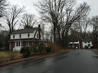
West Trenton is a section of Ewing Township in Mercer County, New Jersey, United States. It is a suburban area located adjacent to the northwestern portion of the city of Trenton, from which it derives its name. Located at the intersection of Bear Tavern Road/Grand Avenue and West Upper Ferry Road, it is one of the oldest settlements in Ewing Township.

Eastern Parkway is a major boulevard that runs through a portion of the New York City borough of Brooklyn. Designed by Frederick Law Olmsted and Calvert Vaux, it was the world's first parkway, having been built between 1870 and 1874. At the time of its construction, Eastern Parkway went to the eastern edge of Brooklyn, hence its name.
U.S. Route 1 is a major north–south U.S. Highway, extending from the Florida Keys in the south to the Canadian border in the north. In the U.S. state of Pennsylvania, US 1 runs for 81 miles (130 km) from the Maryland state line near Nottingham to the New Jersey state line near Trenton, through the southeastern portion of the state. The route runs southwest to northeast, and serves as a major arterial road for many of the suburbs in the Delaware Valley area. South of Philadelphia, the road mostly follows the alignment of the old Baltimore Pike. Within Philadelphia, it mostly follows Roosevelt Boulevard.

U.S. Route 13 is a U.S. highway running from Fayetteville, North Carolina north to Morrisville, Pennsylvania. The route runs for 49.33 mi (79.39 km) through the Philadelphia metropolitan area in the U.S. state of Pennsylvania. The route enters the state from Delaware in Marcus Hook, Delaware County. It continues in a northeasterly direction through Delaware County, passing through the city of Chester before heading through suburban areas along Chester Pike to Darby. US 13 enters the city of Philadelphia on Baltimore Avenue and runs through West Philadelphia to University City, where it turns north along several city streets before heading east across the Schuylkill River along Girard Avenue. The route turns north and heads to North Philadelphia, where it runs northeast along Hunting Park Avenue. US 13 becomes concurrent with US 1 on Roosevelt Boulevard, continuing into Northeast Philadelphia. US 13 splits southeast on one-way streets before heading northeast out of the city on Frankford Avenue. The route continues into Bucks County as Bristol Pike, heading northeast to Bristol, where it turns into a divided highway. US 13 becomes a freeway in Tullytown and continues north to its terminus at US 1 near Morrisville. US 13 roughly parallels Interstate 95 (I-95) through its course in Pennsylvania.
Wilburtha is a section of Ewing Township in Mercer County, New Jersey, United States. Located where Wilburtha Road crosses the Delaware and Raritan Canal, it is one of the oldest settlements in Ewing Township and developed due to the construction of the canal in the early 19th century. The community was known as Greensburg before adopting its current name in 1883. The Yardley–Wilburtha Bridge once connected Wilburtha to Yardley, Pennsylvania on the other side of the Delaware River. The Belvidere Delaware Railroad once passed through the village. Today, Wilburtha is primarily a residential neighborhood consisting of detached, single-family homes, the majority of which were built in the 1950s through the early 1980s.

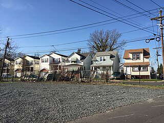
Braeburn Heights is a neighborhood located within Ewing Township in Mercer County, New Jersey, United States. It is a residential neighborhood primarily consisting of detached, single family homes built from the 1940s through the 1970s.
Prospect Park is a neighborhood located within Ewing Township in Mercer County, New Jersey, United States.

Hiltonia is a neighborhood located within the city of Trenton in Mercer County, New Jersey, United States. Hiltonia is just northwest of Cadwalader Park.

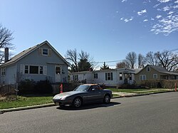
The Island is a neighborhood in the city of Trenton in Mercer County, New Jersey, United States. It is primarily a residential neighborhood consisting of detached, single-family homes and semi-attached (twin) residences built in the 1920s.

Ewing/Carroll is a neighborhood located within the city of Trenton in Mercer County, New Jersey, United States. It is considered to be an enclave within the larger Coalport/North Clinton neighborhood.

Cadwalader Heights is a neighborhood located within the city of Trenton in Mercer County, New Jersey, United States. The neighborhood was designed by Frederick Law Olmsted and primarily consists of detached, single-family homes built from 1907 to 1930. Cadwalader Heights is just southeast of Cadwalader Park.

Coalport/North Clinton is a neighborhood located within the city of Trenton in Mercer County, New Jersey, United States. It contains the smaller enclave of Ewing/Carroll.

Shabakunk Hills is a neighborhood located within Ewing Township in Mercer County, New Jersey, United States. The name is derived from the Shabakunk Creek which flows through the neighborhood.