Related Research Articles
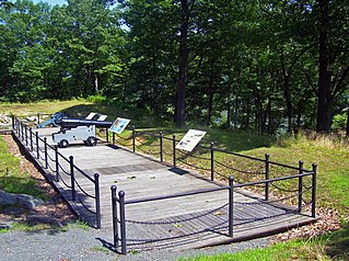
Fort Montgomery was a fortification built on the west bank of the Hudson River in Highlands, New York by the Continental Army during the American Revolution. Erected in 1776, Fort Montgomery was one of the first major investments by the Americans in strategic construction projects.

Danube is a town in Herkimer County, New York, United States. The population was 801 at the 2020 census, down from 1,039 in 2010. Early Palatine German immigrants in the eighteenth century named the town after the Danube River in Europe.

Fonda is a village in and the county seat of Montgomery County, New York, United States. The population was 668 at the 2020 census. The village is named after Douw Fonda, a Dutch-American settler who was killed and scalped in 1780, during a Mohawk raid in the Revolutionary War, when the tribe was allied with the British.
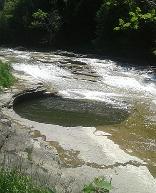
Canajoharie is a village in the Town of Canajoharie in Montgomery County, New York, United States. As of the 2010 census, the village had a population of 2,229. The name is said to be a Mohawk language term meaning "the pot that washes itself," referring to the "Canajoharie Boiling Pot," a circular gorge in the Canajoharie Creek, just south of the village.

This is a list of properties and districts listed on the National Register of Historic Places in Pennsylvania. As of 2015, there are over 3,000 listed sites in Pennsylvania. All 67 counties in Pennsylvania have listings on the National Register.

Charles M. Goodman was an American architect who made a name for his modern designs in suburban Washington, D.C., after World War II. While his work has a regional feel, he ignored the colonial revival look so popular in Virginia. Goodman was quoted in the 1968 survey book Architecture in Virginia as saying that he aimed to "get away from straight historical reproduction."
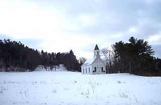
Mohawk Upper Castle Historic District is a historic district in Herkimer County, New York that was declared a National Historic Landmark in 1993. Located south of the Mohawk River, it includes the Indian Castle Church, built in 1769 by Sir William Johnson, British Superintendent of Indian Affairs, as a missionary church for the Mohawk in the western part of their territory; the Brant Family Barn, a rare surviving example of Dutch colonial barns in the Mohawk Valley; as well as important archaeological site areas revealing life in Nowadaga, as the western part of the Mohawk village of Canajoharie was known. The fortified village was called the Upper Castle by European colonists.
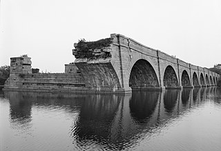
Schoharie Crossing State Historic Site, also known as Erie Canal National Historic Landmark, is a historic district that includes the ruins of the Erie Canal aqueduct over Schoharie Creek, and a 3.5-mile (5.6 km) long part of the Erie Canal, in the towns of Glen and Florida within Montgomery County, New York. It was the first part of the old canal to be designated a National Historic Landmark, prior to the designation of the entire New York State Barge Canal as an NHL in 2017.
Fort Hunter is a hamlet in the Town of Florida in Montgomery County, New York, United States, west of the capital at Albany, on the south bank of the Mohawk River and on the northeast bank of Schoharie Creek.

This is a list of the National Register of Historic Places listings in Wood County, Ohio.

Graham Cave is a Native American archeological site near Mineola, Missouri in Montgomery County in the hills above the Loutre River. It is located in the 356 acre Graham Cave State Park. The entrance of the sandstone cave forms a broad arch 120 feet (37 m) wide and 16 feet (5 m) high. Extending about 100 feet (30 m) into the hillside, the cave protects an historically important Pre-Columbian archaeological site from the ancient Dalton and Archaic period dating back to as early as 10,000 years ago.
Garoga Site is an archaeological site located at Ephratah in Fulton County, New York. It is also known as Las-7, New York State Office of Parks, Recreation, and Historic Preservation Unique Site No. A035-04-0001. It is one of three Mohawk Indian village sites excavated by archaeologist Robert E. Funk in 1969–1970.
Klock Site is an archaeological site located at Ephratah in Fulton County, New York. It is also known as Las. 8-4, New York State Office of Parks, Recreation, and Historic Preservation Unique Site No. A035-04-0005. It is one of three Mohawk Indian village sites excavated by archaeologist Robert E. Funk in 1969-1970.
Smith Pagerie Site, also known as Las. 11–4, New York State Office of Parks, Recreation, and Historic Preservation Unique Site No. A035-04-0002, is an archaeological site located at Ephratah in Fulton County, New York, US. It is one of three Mohawk Indian village sites excavated by the archaeologist Robert E. Funk in 1969–1970.

Van Alstyne Homestead is a historic home located at Canajoharie in Montgomery County, New York. It is a long, low rectangular house with a steeply pitched gambrel roof in the Dutch Colonial style. The original fieldstone house was built before 1730 and has three rooms with a garret under the roof. A 2+1⁄2-story frame addition runs across the rear.

Caughnawaga Indian Village Site is an archaeological site located just west of Fonda in Montgomery County, New York. It is the location of a 17th-century Mohawk nation village. One of the original Five Nations of the Iroquois League, or Haudenosaunee, the Mohawk lived west of Albany and occupied much of the Mohawk Valley. Other Iroquois nations were located west of them and south of the Great Lakes.

The Ehle House Site is an archaeological site located at Nelliston in Montgomery County, New York. The house that stood at this site was built in 1729 by Jacobus Ehle, a Palatine German, who preached in the Hudson Valley and then made his way to the Mohawk Valley. The house is no longer standing.
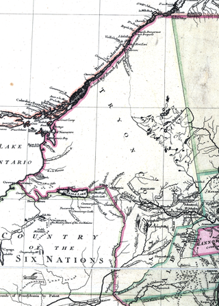
Tryon County was a county in the colonial Province of New York in the British American colonies. It was created from Albany County on March 24, 1772, and was named for William Tryon, the last provincial governor of New York. The county's boundaries extended much further than any current county. Its eastern boundary with the also-new Charlotte County ran "from the Mohawk River to the Canada line, at a point near the old village of St. Regis and passing south to the Mohawk between Schenectady and Albany." It extended north to the St. Lawrence River; its western boundary was the Treaty of Fort Stanwix's Line of Property, following the Unadilla River, Oneida Lake, Onondaga River and Oswego River to Lake Ontario, as the Iroquois Confederacy still controlled locations further west in the Indian Reserve. Tryon County's seat was Johnstown, which is today the county seat of Fulton County. The Tryon County Courthouse, built in 1772–1773, was listed on the National Register of Historic Places in 1972. The Tryon County Jail, also built in 1772–1773, was listed on the National Register of Historic Places in 1981.
Tionondogen was the westernmost and most important of the three large palisaded towns of the Mohawk Nation of Iroquois. These towns were termed "castles" by the Europeans. Because of its position as the farthest upstream on the Mohawk River Tionondogen is often referred to as the "Upper Castle".
References
- 1 2 "National Register Information System". National Register of Historic Places . National Park Service. March 13, 2009.
- ↑ Three Rivers, Hudson~Mohawk~Schoharie, History From America's Most Famous Valleys: Robert M. Hartley Collections of Indian Artifacts (Chiefly of the Mohawk Valley) and Military Uniform Buttons in the Margaret Reaney Memorial Library, St. Johnsville, NY; Prepared by The Montgomery County Department of History and Archives and The Van Epps-Hartley Chapter of the New York State Archaeological Association, Published by Mrs. Robert M. Hartley, 1943
