Related Research Articles
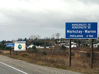
Markstay-Warren is a town in the Canadian province of Ontario, located in the Sudbury District. Highway 17, from the city limits of Greater Sudbury to the Sudbury District's border with Nipissing District, lies entirely within Markstay-Warren. The town had a population of 2,656 in the Canada 2016 Census.

The Regional District of Okanagan-Similkameen (RDOS) is in southern British Columbia, adjacent to the U.S. state of Washington. It is bounded by Fraser Valley Regional District to the west, Thompson-Nicola Regional District and Regional District of Central Okanagan to the north, Regional District of Kootenay Boundary to the east, and by Okanogan County, Washington to the south. At the 2011 census the population was 80,742. The district covers a land area of 10,413.44 square kilometres (4,020.65 sq mi). The administrative offices are in the City of Penticton.

Division No. 6 is one of eighteen census divisions in the province of Saskatchewan, Canada, as defined by Statistics Canada. It is located in the south-central part of the province. The most populous community in this division is Regina, the provincial capital.

Division No. 10 is one of eighteen census divisions in the province of Saskatchewan, Canada, as defined by Statistics Canada. It is located in the east-central part of the province. The most populous community in this division is Wynyard.

Division No. 13 is one of eighteen census divisions in the province of Saskatchewan, Canada, as defined by Statistics Canada. It is located in the western part of the province, bordering Alberta. The most populous community in this division is Kindersley.

Colonsay is a town in the Rural Municipality of Colonsay No. 342, in the Canadian province of Saskatchewan. Colonsay is located on Highway 16 running east–west in central Saskatchewan near the intersection with Highway 2.

Leroy is a town in the province of Saskatchewan, Canada.

The Rural Municipality of Mayfield No. 406 is a rural municipality (RM) in the Canadian province of Saskatchewan within Census Division No. 16 and SARM Division No. 6.

The Rural Municipality of Mountain is a rural municipality (RM) in the Parkland Region of Manitoba, western Canada.
Argo is an unincorporated community or a siding administered by the rural municipality of Biggar No. 347, in the Canadian province of Saskatchewan. Argo was located on the Dodsland Branch of the Canadian National Railway between Biggar and Duperow. The closest town is Biggar to the northeast. Biggar railway station is a divisional point for the Canadian National Railway (CNR).
The Rural Municipality of Gilbert Plains is a former rural municipality (RM) in the Canadian province of Manitoba. It was originally incorporated as a rural municipality on March 30, 1897. It ceased on January 1, 2015 as a result of its provincially mandated amalgamation with the Town of Gilbert Plains to form the Gilbert Plains Municipality.
North Shore Fishing Lake is a hamlet in the Rural Municipality of Sasman No. 336, Saskatchewan, Canada. Listed as a designated place by Statistics Canada, the hamlet had a population of 50 in the Canada 2016 Census. It is located on the north-eastern shore of Fishing Lake.

The Rural Municipality of Lake Alma No. 8 is a rural municipality (RM) in the Canadian province of Saskatchewan within Census Division No. 2 and SARM Division No. 2. Located in the southeast portion of the province, it is adjacent to the United States border, neighbouring Sheridan County in Montana and Divide County in North Dakota.
Quinton is a village in the Canadian province of Saskatchewan within the Rural Municipality of Mount Hope No. 279 and Census Division No. 10. The village is located on Highway 15 between the Town of Raymore and the Village of Punnichy. It is near the administrative office of the Kawacatoose First Nations.

The Rural Municipality of Ituna Bon Accord No. 246 is a rural municipality (RM) in the Canadian province of Saskatchewan within Census Division No. 10 and SARM Division No. 4.
The Rural Municipality of Sasman No. 336 is a rural municipality (RM) in the Canadian province of Saskatchewan within Census Division No. 10 and SARM Division No. 4.
The Rural Municipality of Nipawin No. 487 is a rural municipality (RM) in the Canadian province of Saskatchewan within Census Division No. 14 and SARM Division No. 4.
Hardy is a hamlet in The Gap Rural Municipality No. 39, Saskatchewan, Canada. The community had a population of 5 in 2001. It previously held the status of village until January 1, 2000. The hamlet is located 82 km south west of the City of Weyburn 10 km west of highway 6 and 5 km north of highway 705. Hardy was named for the great 19th-century English novelist and poet Thomas Hardy.
Kipabiskau is a hamlet in Rural Municipality of Pleasantdale No. 398, Saskatchewan, Canada. It previously held the status of a village until April 30, 1973. The hamlet is located on the north shore of Kipabiskau Lake about 28 kilometres (17 mi) east of the village of Pleasantdale on highway 773.

Amulet is an unincorporated community in Norton Rural Municipality No. 69, Saskatchewan, Canada. It previously held village status until January 1, 1965. The community has a population of 33 people.
References
- ↑ Disorganized Rural Municipalities Archived 2012-02-25 at the Wayback Machine
- ↑ "2006 Community Profiles". 2006 Canadian Census . Statistics Canada. August 20, 2019.
- ↑ "2001 Community Profiles". 2001 Canadian Census . Statistics Canada. July 18, 2021.