
Dhule is one of the largest cities in Maharashtra, and central region of India. The city located in the Dhule District in the northwestern part of Maharashtra state, India known as West Khandesh. Situated on the banks of Panzara River, Dhule is the regional headquarters of MIDC, Forest, Taapi River Fedreshan, RTO, and MTDC.
Sangli is a metropolitan town and the headquarters of Sangli District in Maharashtra, in south-western India. It has earned the nickname "Turmeric City of India" for being the hub of the Asia's largest production and trade of this spice. Sangli is situated on the banks of river Krishna and houses many sugar factories. A significant city in South-Western India, it lies 376 km from Mumbai, 230 km from Pune and 638 km from Bangalore. The city has a significant healthcare hub, including its twin City Miraj. Sangli-Miraj combined has more than 1000+ Hospitals and Clinics. Sangli is known as Turmeric city for its global turmeric trade as well grapes, raisins, jaggery and the most significant number of sugar factories in India, with district area having has more than 30 sugar factories. The Sangli region boasts the largest raisin market in Asia. Sangli-Miraj-Kupwad municipal corporation (SMKMC) along with its Urban Agglomeration consisting satellite towns of Madhavnagar & Budhgaon is 93rd biggest in India.
Palghar is a prominent town in the Konkan division of Maharashtra state, India, and a municipal council. It is Strategically located within the Mumbai Metropolitan Region, and since 2014, it has been the administrative capital of the Palghar district. Palghar plays a crucial role in Western Line of the Mumbai Suburban Railway in the busy Mumbai-Ahmedabad rail corridor. The town is located approximately 87 kilometers north of Mumbai, about 35 kilometers north of Virar, and about 24 kilometers west of the Mumbai-Ahmedabad National Highway at Manor and Mumbai is approximately 50+ km from Palghar.
Kirloskarvadi is India's second-oldest industrial township that developed around the Kirloskar Brothers Ltd factory in the Palus, Sangli district, in Maharashtra state, India. It is the second-oldest industrial township in India. On 10 March 2010, Kirloskarvadi celebrated 100 years of its establishment. Kirloskarvadi is a rapidly growing satellite suburb of Palus city. The famous holy place of God Datta Maharaj Audumbar is just 10 km away. While Sagareshwar picnic spot is around 8–10. The town has centric connectivity between Satara-Sangli-Kolhapur

Khordha district is an administrative division of the state of Odisha, India. It was formed on April 1, 1993, by the division of former Puri District into Puri, Khordha and Nayagarh districts. In the year 2000 the district name was changed to Khordha. The district headquarters is Khordha Town. The capital city of Bhubaneswar is located in this district. Khordha is the most urbanized of all the districts of Odisha.
Murtijapur is a Municipal council and one of the taluka of district of Akola of the Amravati division of the Vidarbha region of Maharashtra.
Pune Division is one of the six administrative divisions of the Indian State of Maharashtra. Pune Division is bound by Konkan Division to the west, Nashik Division to the north, Aurangabad Division to the east, and the state of Karnataka to the south.

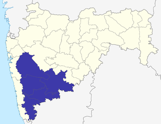
Sangli district is a district of Maharashtra state in India. Sangli city is the district headquarters. It is bordered by Satara district, Solapur district to the North, Karnataka state to the South-East, by Kolhapur district to South-West and by narrow portion on the East side to Ratnagiri district. It is present on the southern tip of Maharashtra.
Champdani is a city and a municipality of Hooghly district in the Indian state of West Bengal. It is under Bhadreswar police station in Chandannagore subdivision. It is a part of the area covered by Kolkata Metropolitan Development Authority (KMDA). This town is famous for six factories, viz.the GIS Cotton Mill, Dalhousie Jute Mill, North Brook jute Mill, Angus jute Mill, Champdany Garbage Refinary Ltd, Lagan Engineering, and Braithwate Ltd.
Ichalkaranji ([it͡səlkəɾəɳd͡ʒiː]) is a city in Kolhapur District, Maharashtra. It is situated at the bank of the Panchganga River. Its textile industry has led to the nickname 'Manchester City of Maharashtra'.

Karad is a town in Satara district of Indian state of Maharashtra. It is located 302 km (180.19 miles) from Mumbai, 74 km from Sangli and 162 km from Pune. It lies at the confluence of Koyna River and the Krishna River known as the "Pritisangam". The two rivers originate at Mahabaleshwar, which is around 100 km from Karad. Karad is well known for sugar production and is known as the sugar bowl of Maharashtra owing to the presence of many sugar factories in and around Karad. It is considered an important educational hub in Western Maharashtra due to the presence of many prestigious educational institutes. Karad is resting place of the first chief minister of Maharashtra Yashwantrao Chavan situated at the confluence of the Krishna and Koyana rivers. It is ranked as the cleanest town in Swachh Survekshan 2020 in the category of population with less than 1 lakh.
Madhavnagar is a small city in sangli and now Suburb of Sangli Urban; Sangli district in the Indian state of Maharashtra.
Tasgaon is a city in Maharashtra and Taluka in Sangli district in the Indian state of Maharashtra. Tasgaon city is developing city in Maharashtra. Tasgaon was given as Jahagir to Parshuram Bhau Tasgaonkar by Narayanrao Ballal Peshwa in 1774. Tasgaon Sansthan was lapsed by British during ruling of Shrimant Ganpatrao Tasgaonkar.
Jalna is a city in Jalna district in the Aurangabad Division, or Marathwada region, of the Indian state of Maharashtra. It was part of Hyderabad State as a tehsil of Aurangabad district, before Jalna district was formed effective 1 May 1981. Jalna become Maharashtra's 29th Municipal Corporation.
Palus is a city and municipal council in sangli district.
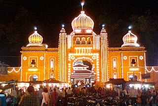
Kavathe-Mahankal is a tehsil in Miraj subdivision of Sangli district in the Indian state of Maharashtra. This is famous for Mahankali Devi temple and Mallikarjun temple. There was also a sugar factory, named after the same Goddess Mahankali sugar factory.
Ashta is a city and a municipal council in Sangli district in the state of Maharashtra, India. It is located at 16.95°N 74.4°E. It has an average elevation of 567 metres (1860 ft). The name "Ashta" comes from the legend that Lord Shri Ram established eight (Asht) Lord Mahadev temples in this area. The city is divided into 19 wards for which elections are held every 5 years. The Ashta Municipal Council has the population of 37,105 of which 19,171 are males while 17,934 are females as per the report released by Census India 2011.

Latur is a city in Latur district of the Maharashtra state of India. Before 1982 Latur was a part of the then Osmanabad district. The city is a tourist hub surrounded by many historical monuments Kharosa Caves. The most spoken language in Latur is Marathi. The city's quality of education attracts students from all over Maharashtra. It is a drought prone area with acute water shortage in its city and rural areas. The economy is agriculture intensive, but in recent years is also dependent on Educational sector and its allied activities. Industrial development is minimal in the district. Latur is 43 kilometers from the epicenter of the devastating 1993 Latur earthquake.

The Sangli-Miraj-Kupwad Municipal Corporation (SMKC) is the governing body of the Sangli Metropolitan Region in the Indian state of Maharashtra. It is located in Sangli. The municipal corporation consists of democratically-elected members, is headed by a mayor and administers the city's infrastructure and public services. It was founded on 9 February 1998. SMKC serves an area approximately 118.18 km2 and provides civil services and facilities for more than 6.5 lakh (650,000) people.

Idris Naikwadi is an Indian politician from Maharashtra. He is a nominated member of the Maharashtra Legislative Council representing Nationalist Congress Party. He is the only muslim in the Legislature. He is former mayor of Sangli, Miraj and Kupwad City Municipal Corporation in Maharashtra. He was one of the star campaigners of Nationalist Congress Party for 2024 Maharashtra Legislative Assembly election.
