Silverdale, Queensland

Last updated

Silverdale
Queensland
Paddocks along Kengoon Road Silverdale.jpg
Paddocks along Kengoon Road, 2015
Australia Queensland location map.svg
Red pog.svg
Silverdale
Coordinates 27°53′17″S152°35′48″E / 27.8880°S 152.5966°E / -27.8880; 152.5966 Coordinates: 27°53′17″S152°35′48″E / 27.8880°S 152.5966°E / -27.8880; 152.5966
Population120 (2016 census) [1]
 • Density3.09/km2 (8.0/sq mi)
Postcode(s) 4307
Area38.8 km2 (15.0 sq mi)
Time zone AEST (UTC+10:00)
LGA(s) Scenic Rim Region
State electorate(s) Scenic Rim
Federal division(s) Wright
Suburbs around Silverdale:
Rosevale Warrill View Radford
Rosevale Silverdale Munbilla
Frazerview Kalbar Kents Lagoon

Silverdale is a rural locality in the Scenic Rim Region, Queensland, Australia. [2] In the 2016 census, Silverdale had a population of 120 people. [1]

Contents

Geography

Silverdale is located in the Fassifern Valley farming area along the Cunningham Highway. The eastern boundary of Silverdale is marked by Warrill Creek, a tributary of the Bremer River.

History

In July 1909, a public meeting was held to discuss the opening of a school in the district; the committee believed 32 students would attend the school. [3] Tenders were called to construct the school building in November 1909; [4] W.C. Cowell's tender for £ 183/15/0 was accepted in December 1909. [5] Silverdale State School opened on 23 May 1910. [3] It closed on 28 January 1963 and the students transferred to Engelsburg State School (now Kalbar State School) in Kalbar. [6] [7] [8] The school was at 5382 Cunningham Highway ( 27°53′15″S152°36′41″E / 27.8875°S 152.6114°E / -27.8875; 152.6114 (Silverdale State School (former)) ). [9] [10] [11]

At the 2011 census the locality and surrounds recorded a population of 434. [12]

Facilities

Silverdale has one of more than 30 cattle tick clearing facilities in Queensland. [13]

Events

The locality is home to the Annual Silverdale Show and Sale.

Related Research Articles

Roadvale, Queensland Town in Queensland, Australia

Roadvale is a rural locality in the Scenic Rim Region, Queensland, Australia. In the 2016 census, Roadvale had a population of 286 people.

Aratula Town in Queensland, Australia

Aratula is a rural town and locality in the Scenic Rim Region, Queensland, Australia. In the 2016 census, Aratula had a population of 532 people.

Fassifern Valley

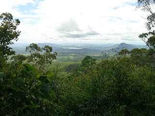
Fassifern Valley is a valley of the Scenic Rim in South East Queensland. Towns found in the valley include Harrisville, Kalbar, Roadvale, Warril View and Aratula. Fassifern Valley is known as a carrot-producing area, as well as for growing potatoes, onions, pumpkins and melons. It is one of four vegetable-producing regions in southern Queensland, the others being the Lockyer Valley, the eastern Darling Downs and the Granite Belt.

The Mount Edwards railway line was a branch railway in the Scenic Rim region of South East Queensland, Australia. The lines serves a number of small towns in the Fassifern Valley. The first stage of the Mount Edwards line opened from Munbilla to Engelsburg on 17 April 1916, but the next stage to Mount Edwards was not completed until 7 October 1922. The line closed on 1 November 1960.

Kalbar, Queensland Town in Queensland, Australia

Kalbar is a rural town and locality in the Scenic Rim Region, Queensland, Australia. In the 2016 census, the locality of Kalbar had a population of 1,093 people.

Warrill View, Queensland Town in Queensland, Australia

Warrill View is a rural town and locality in the Scenic Rim Region, Queensland, Australia. In the 2016 census, Warrill View had a population of 240 people.

South Kolan Town in Queensland, Australia

South Kolan is a rural locality in the Bundaberg Region, Queensland, Australia. In the 2016 census, South Kolan had a population of 1,061 people.

Harrisville, Queensland Town in Queensland, Australia

Harrisville is a rural town and locality in the Scenic Rim Region, Queensland, Australia. In the 2016 census the locality of Harrisville had a population of 613 people.

Wiss Brothers Store

Wiss Brothers Store is a heritage-listed shopping centre at 101 George Street, Kalbar, Queensland, Australia. It was built from 1890 to 1909. It was added to the Queensland Heritage Register on 29 October 1992.

Kents Lagoon, Queensland Suburb of Scenic Rim Region, Queensland, Australia

Kents Lagoon is a rural locality in the Scenic Rim Region, Queensland, Australia. In the 2016 census, Kents Lagoon had a population of 56 people.

Frazerview, Queensland Suburb of Scenic Rim Region, Queensland, Australia

Frazerview is a rural locality in the Scenic Rim Region, Queensland, Australia. In the 2016 census, Frazerview had a population of 34 people.

Teviotville, Queensland Town in Queensland, Australia

Teviotville is a rural locality in the Scenic Rim Region, Queensland, Australia. In the 2016 census, Teviotville had a population of 125 people.

Charlwood, Queensland Suburb of Scenic Rim Region, Queensland, Australia

Charlwood is a rural locality in the Scenic Rim Region, Queensland, Australia. In the 2016 census Charlwood had a population of 139 people.

Fassifern, Queensland Suburb of Scenic Rim Region, Queensland, Australia

Fassifern is a rural locality in the Scenic Rim Region, Queensland, Australia. In the 2016 census, Fassifern had a population of 21 people.

Fassifern Valley, Queensland Suburb of Scenic Rim Region, Queensland, Australia

Fassifern Valley is a rural locality in the Scenic Rim Region, Queensland, Australia. In the 2016 census, Fassifern Valley had a population of 91 people.

Moogerah, Queensland Suburb of Scenic Rim Region, Queensland, Australia

Moogerah is a rural locality in the Scenic Rim Region, Queensland, Australia. In the 2016 census, Moogerah had a population of 234 people.

Mount Edwards, Queensland Suburb of Scenic Rim Region, Queensland, Australia

Mount Edwards is a rural locality in the Scenic Rim Region, Queensland, Australia. In the 2016 census, Mount Edwards had a population of 63 people.

Obum Obum, Queensland Suburb of Scenic Rim Region, Queensland, Australia

Obum Obum is a rural locality in the Scenic Rim Region, Queensland, Australia. In the 2016 census, Obum Obum had a population of 131 people.

Kulgun, Queensland Suburb of Scenic Rim Region, Queensland, Australia

Kulgun is a locality in the Scenic Rim Region, Queensland, Australia. In the 2016 census, Kulgun had a population of 67 people.

Morwincha, Queensland Suburb of Scenic Rim Region, Queensland, Australia

Morwincha is a rural locality in the Scenic Rim Region, Queensland, Australia. In the 2016 census, Morwincha had a population of 30 people.

References

  1. 1 2 Australian Bureau of Statistics (27 June 2017). "Silverdale (SSC)". 2016 Census QuickStats. Retrieved 20 October 2018. OOjs UI icon edit-ltr-progressive.svg
  2. "Silverdale – locality in Scenic Rim Region (entry 45187)". Queensland Place Names. Queensland Government . Retrieved 17 November 2019.
  3. 1 2 "THE PROPOSED SILVERDALE SCHOOL". Queensland Times . LI, (7571). Queensland, Australia. 27 July 1909. p. 4 (DAILY). Retrieved 4 January 2022 via National Library of Australia.CS1 maint: extra punctuation (link)
  4. "Advertising". The Brisbane Courier . LXVI, (16, 175). Queensland, Australia. 13 November 1909. p. 2. Retrieved 4 January 2022 via National Library of Australia.CS1 maint: extra punctuation (link)
  5. "STATE SCHOOL TENDERS". Queensland Times . LI, (7691). Queensland, Australia. 17 December 1909. p. 4 (DAILY). Retrieved 4 January 2022 via National Library of Australia.CS1 maint: extra punctuation (link)
  6. Queensland Family History Society (2010), Queensland schools past and present (Version 1.01 ed.), Queensland Family History Society, ISBN   978-1-921171-26-0
  7. "Agency ID 6216, Silverdale State School". Queensland State Archives . Retrieved 4 January 2022.
  8. "History". Kalbar State School. 4 January 2019. Archived from the original on 18 November 2019. Retrieved 3 January 2022.
  9. "Queensland Two Mile series sheet 2m38" (Map). Queensland Government. 1955. Retrieved 4 January 2022.
  10. "Flinders" (Map). Queensland Government. 1954. Archived from the original on 29 April 2020. Retrieved 4 January 2021.
  11. "Queensland Globe". State of Queensland . Retrieved 4 January 2022.
  12. Australian Bureau of Statistics (31 October 2012). "Mundbilla (State Suburb)". 2011 Census QuickStats. Retrieved 31 March 2015. OOjs UI icon edit-ltr-progressive.svg
  13. "Cattle tick clearing facilities". Department of Agriculture and Fisheries. 2 August 2013. Archived from the original on 2 April 2015. Retrieved 31 March 2015.

Further reading

Commons-logo.svg Media related to Silverdale, Queensland at Wikimedia Commons