Southern Coastal Plain (ecoregion)

Last updated
Southern Coastal Plain
US Southern Coastal Plain Map.jpg
Satellite imagery of the Southern Coastal Plain, with state boundaries
Southern Coastal Plain (ecoregion)
Southern Coastal Plain ecoregion
Ecology
Realm Nearctic
Biome
Borders
Geography
Area139,412 km2 (53,827 sq mi)
CountryUnited States
States
GeologyPlains, karst, alluvial deposits, xeric uplands
Climate type Humid subtropical (Cfa)

The North American Southern Coastal Plain is a Level III ecoregion designated by the Environmental Protection Agency (EPA) in six U.S. states. The region stretches across the Gulf coast from eastern Louisiana to Florida, forms the majority of Florida, and forms the coastlines of Georgia and much of South Carolina. It has been divided into twelve Level IV ecoregions.

Contents

Description

Terrain

Mostly flat plains, the region also includes barrier islands, coastal lagoons, marshes, and swampy lowlands along the Gulf and Atlantic coasts. In Florida, an area of more rolling discontinuous highlands contains numerous lakes. This ecoregion is lower in elevation with less relief and wetter soils than the Southeastern Plains ecoregion to the north. Ultisols, Spodosols, and Entisols are common, with thermic and hyperthermic soil temperature regimes and aquic and some udic soil moisture regimes. [1] Orlando

Climate

The ecoregion has a mild mid-latitude humid subtropical climate, characterized by hot humid summers and warm to mild winters. [1] In the Köppen climate classification scheme, the area is classified within Cfa: humid subtropical climates. [2] The mean annual temperature is approximately 19 °C (66 °F) to 22 °C (72 °F). The frost-free period ranges from 280 to 360 days. The mean annual precipitation is 1,338 millimetres (52.7 in), ranging from 1,170 millimetres (46 in) to 1,650 millimetres (65 in). [1]

Orlando, Florida (ecoregion 75c)
Climate chart (explanation)
J
F
M
A
M
J
J
A
S
O
N
D
 
 
2.5
 
 
72
50
 
 
2
 
 
75
52
 
 
3
 
 
79
56
 
 
2.6
 
 
84
61
 
 
4
 
 
88
66
 
 
8.1
 
 
91
72
 
 
7.5
 
 
92
73
 
 
7.7
 
 
92
74
 
 
6.4
 
 
90
72
 
 
3.5
 
 
85
66
 
 
1.8
 
 
78
58
 
 
2.5
 
 
74
53
Average max. and min. temperatures in °F
Precipitation totals in inches
Source: National Weather Service [3]
Metric conversion
J
F
M
A
M
J
J
A
S
O
N
D
 
 
63
 
 
22
10
 
 
52
 
 
24
11
 
 
77
 
 
26
13
 
 
66
 
 
29
16
 
 
102
 
 
31
19
 
 
204
 
 
33
22
 
 
189
 
 
33
23
 
 
195
 
 
33
23
 
 
162
 
 
32
22
 
 
88
 
 
29
19
 
 
45
 
 
26
15
 
 
63
 
 
23
12
Average max. and min. temperatures in °C
Precipitation totals in mm

Hydrology

In the Southern Coastal Plain, there are numerous low-gradient, perennial streams and large rivers, wetlands, and lakes. [1]

Major waterways include:

Major wetlands and lakes include:

Vegetation

Once covered mainly by longleaf pine flatwoods and savannas, this ecoregion also had a variety of other communities that supported slash pine, pond pine, pond cypress, beech, sweetgum, southern magnolia, white oak, and laurel oak forest. Near rivers, there are southern floodplain forests with bald cypress, pond cypress, water tupelo, bottomland oaks, sweetgum, green ash, and water hickory. [1]

A gopher tortoise, a species whose range is roughly coextensive with the Southern Coastal Plain Florida gopher tortoise.jpg
A gopher tortoise, a species whose range is roughly coextensive with the Southern Coastal Plain

Wildlife

Common species of the Southern Coastal Plain ecoregion include black bear, white-tailed deer, bobcat, marsh rabbit, fox squirrel, manatee, egret, blue heron, red-cockaded woodpecker, indigo bunting, Florida scrub jay, box turtle, gopher tortoise, southern dusky salamander, scrub lizard, cottonmouth, and alligator. [1]

Orlando, Florida, located in the Central Florida Ridges and Uplands (75c) Orlando downtown 2011.jpg
Orlando, Florida, located in the Central Florida Ridges and Uplands (75c)

Land Use/Human Activities

Human land uses of this region include pine plantations and forestry, pasture for beef cattle, citrus groves, tourism and recreation, and fish and shellfish production. There are some large areas of urban, suburban, and industrial uses. Larger cities from north to south include Georgetown, Charleston, Savannah, Waycross, Brunswick, Jacksonville, Hammond, Slidell, Gulfport, Biloxi, Pascagoula, Mobile, Pensacola, Gainesville, Ocala, Orlando, Tampa, St. Petersburg, and Fort Myers. [1]

Level IV ecoregions

Map of the Southern Coastal Plain's Level IV ecoregions US Southern Coastal Plain ecoregion map.svg
Map of the Southern Coastal Plain's Level IV ecoregions

Gulf Coast Flatwoods (75a)

Apalachicola National Forest, located in the Gulf Coast Flatwoods (75a) ANF landscape01.jpg
Apalachicola National Forest, located in the Gulf Coast Flatwoods (75a)

In Louisiana, Mississippi, and Alabama, the Gulf Coast Flatwoods is a narrow region of nearly level terraces and delta deposits composed of Quaternary sands and clays. Wet, sandy flats and broad depressions that are locally swampy are usually forested, while some of the better-drained land has been cleared for pasture or crops. [4]

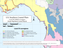
In Florida, the Gulf Coast Flatwoods expand into a wider area, which borders the central uplands (75c) on the east, sharing the same southern terminus as the Big Bend Coastal Marsh (75l) just north of Tampa.

Settlements in the Gulf Coast Flatwoods include Hammond, Slidell, Gulfport, Biloxi, Mobile, Pensacola, and Panama City. Protected areas include Bogue Chitto National Wildlife Refuge, Apalachicola National Forest, and Lower Suwannee National Wildlife Refuge.

Southwestern Florida Flatwoods (75b)

The Southwestern Florida Flatwoods are a relatively large region of flat topography, sandy soils, and pine scrub dominated by saw palmetto, with pockets of wetland. Brush fires have been important to maintaining this environment and preventing the formation of oak hammocks. [5] Tree species include slash pine, longleaf pine, pond cypress, bald cypress, oak, maple, southern magnolia, gum and hickory. [6] Compared to the Eastern Florida Flatwoods (75d), this region has relatively more xeric upland sands and mining/post-mining soils, and less wetland soil and open water. [7] Vulnerable wildlife species found in the area include Florida panther, Florida black bear, sandhill crane, wood stork and gopher tortoise. [8]

Settlements in the Southwestern Florida Flatwoods include Tampa, Clearwater, St. Petersburg, Sarasota, Port Charlotte, Cape Coral, Lehigh Acres, Immokalee, and the coastal edges of Bonita Springs and Naples. There are numerous (though individually small) protected areas within the region, such as the Withlacoochee State Forest, J. N. "Ding" Darling National Wildlife Refuge, Myakka River State Park, and Okaloacoochee Slough State Forest.

A sandhill crane in Ocala National Forest, in the Central Florida Ridges and Uplands (75c) Sand Hill Crane at Wells Pond in Ocala National Forest - panoramio.jpg
A sandhill crane in Ocala National Forest, in the Central Florida Ridges and Uplands (75c)

Central Florida Ridges and Uplands (75c)

The Central Florida Ridges and Uplands, also called Florida longleaf pine sandhills, are a sandy, elevated, somewhat disjunct region created by marine deposits. The ridges run north–south in the center of the Florida peninsula. An example of sandhills, the region is generally dry and prone to brush fires because of the fast-draining soil, with sandier, faster-draining soil in more abundance at higher elevations. [9] [7] Cities in the Central Florida Ridges and Uplands include Gainesville, Ocala, Deltona, Orlando, and Lakeland. The area includes the Ocala National Forest, the Withlacoochee State Forest, Walk-In-The-Water Wildlife Management Area, and Lake Wales Ridge State Forest.

The region's southern half, latitudinally, extends southeastward from Lake Harris in a narrow ridge, called the Lake Wales Ridge, terminating near the boundary between Highlands and Glade Counties. The ridge is primarily composed of xeric upland sands, falling into adjacent, poorly draining flatwoods (75b and 75d) on either side, averaging 11.7 kilometres (7.3 mi) in width. [7] Elevation of the Lake Wales Ridge typically varies from 38 to 65 metres (125 to 213 ft) above mean sea level. [10] Sugarloaf Mountain, the highest point in peninsular Florida at 95 metres (312 ft), lies within the Lake Wales Ridge. Native vegetation was scrub with white oak, red oak, Archbold oak, Chapman oak, sand live oak, myrtle oak, turkey oak, scrub hickory, slash pine, sand pine, Florida rosemary, saw palmetto, scrub palmetto, and cutthroat grass (endemic to central Florida). [7] [4] Florida's only endemic bird, the Florida scrub jay, and only endemic mammal, the Florida mouse, are extant on the Lake Wales ridge. [7] The Florida sand skink, a species with vulnerable conservation status, is endemic to the Central Florida Ridges and Uplands. [9] Approximately 78% of the ridge's xeric uplands had already been developed by the late 1980s. Human land use includes pasture, citrus groves, pine plantations, sand mining, and residential areas. [7] [9]

Everglades Headwaters National Wildlife Refuge and Conservation Area, in the Eastern Florida Flatwoods (75d) Everglades Headwaters National Wildlife Refuge and Conservation Area.jpg
Everglades Headwaters National Wildlife Refuge and Conservation Area, in the Eastern Florida Flatwoods (75d)

Eastern Florida Flatwoods (75d)

The Eastern Florida Flatwoods are a region extending from Lake Okeechobee in the south to the St. Johns River estuary in the north, though not quite so far as Jacksonville. The region transitions into sandhill (75c) to the west, and features sandy beaches and Atlantic barrier islands on the eastern side. Compared to the Southwestern Florida Flatwoods (75b), this region has relatively more wetland soil and open water, and less xeric upland sands and mining/post-mining soils. [7] Etonia rosemary is an endangered plant endemic to the region. [11] The now-extinct dusky seaside sparrow was endemic to the region. [12]

Settlements in the Eastern Florida Flatwoods include St. Augustine Beach, Elkton, Palatka, Florahome, Georgetown, Flagler Beach, Daytona Beach, Kissimmee, Palm Bay, and Port St. Lucie. Protected areas include Etoniah Creek State Forest, Matanzas State Forest, Tiger Bay State Forest, Lake George State Forest, Lake Woodruff National Wildlife Refuge, St. Johns National Wildlife Refuge, Merritt Island National Wildlife Refuge, Everglades Headwaters National Wildlife Refuge and Conservation Area, and J.W. Corbett Wildlife Management Area.

A wildfire on the Okefenokee Plains (75e) Georgia Honey Prairie fire at Okefenokee (5736773639).jpg
A wildfire on the Okefenokee Plains (75e)

Okefenokee Plains (75e)

The Okefenokee Plains consist of flat plains and low terraces developed on PleistocenePliocene sands and gravels. These plains have slightly higher elevations and less standing water than 75g (Okefenokee Swamp), although there are numerous swamps and bays. Soils are somewhat-poorly to poorly drained. The region has mostly coniferous forest and young pine plantation land cover, with areas of forested wetland. [4]

Sea Island Flatwoods (75f)

The Sea Island Flatwoods are poorly-drained flat plains with lower elevations and less dissection than the adjacent Atlantic Southern Loam Plains (65l). Pleistocene sea levels rose and fell several times creating different terraces and shoreline deposits. Spodosols and other wet soils are common, although small areas of better-drained soils add some ecological diversity. Trail Ridge is in this region, forming the boundary with 75g. Loblolly and slash pine plantations cover much of the region. Water oak, willow oak, sweetgum, blackgum and cypress occur in wet areas. [4]

Bald cypress in Okefenokee Swamp (75g) Bald Cypress swamp.jpg
Bald cypress in Okefenokee Swamp (75g)

Okefenokee Swamp (75g)

The Okefenokee Swamp is a mixture of forested swamp and freshwater marsh with some pine uplands. With Trail Ridge at its eastern boundary, the swamp drains to the south and southwest and contains the headwaters for the St. Marys and Suwannee Rivers. The swamp contains numerous islands, lakes, and thick beds of peat. The slow-moving waters are tea-colored and acidic. Cypress, blackgum, and bay forests are common, with scattered areas of prairie, which are composed of grasses, sedges, and various aquatic plants. Most of this region is within the Okefenokee National Wildlife Refuge. [4]

Bacon Terraces (75h)

The Bacon Terraces include several relatively flat, moderately dissected terraces with subtle east-facing scarps. The terraces, developed on Pliocene–Pleistocene sands and gravels, are dissected in a dendritic pattern by much of the upper Satilla River basin. Cropland is mostly on the well-drained soils on the long, narrow, flat to gently sloping ridges paralleling many of the stream courses. The broad flats of the interfluves are often poorly drained and covered in pine, while bottomland forests are found in the wet, narrow floodplains. [4]

Floodplains and Low Terraces (75i)

Floodplains and Low Terraces are a continuation of the riverine Southeastern Floodplains and Low Terraces (65p) ecoregion across the Southern Coastal Plain. The broad floodplains and terraces of major rivers, such as the Savannah, Ogeechee, Altamaha, and Mobile–Tensaw, make up the region. Composed of stream alluvium and terrace deposits of sand, silt, clay, and gravel, along with some organic muck and swamp deposits, the region includes large sluggish rivers and backwaters with ponds, swamps, and oxbow lakes. River swamp forests of bald cypress and water tupelo and oak-dominated bottomland hardwood forests provide important wildlife habitat. [4]

In South Carolina, the Floodplains and Low Terraces are similar to the Mid-Atlantic Floodplains and Low Terraces (63n) ecoregion which lie in the state's river valleys, such as those of the Edisto River, the Santee River, and the Waccamaw River. [13]

ACE Basin National Wildlife Refuge, in the Sea Islands/Coastal Marsh (75j) ACE Basin-Hollings NWR, April 25, 2022 02.jpg
ACE Basin National Wildlife Refuge, in the Sea Islands/Coastal Marsh (75j)

Sea Islands/Coastal Marsh (75j)

The Sea Islands/Coastal Marsh region is a highly dynamic environment affected by ocean wave, wind, and river action. [4] Quaternary unconsolidated sand, silt, and clay has been laid down as beach, dune, barrier beach, saline marsh, terrace, and nearshore marine deposits. Mostly sandy soils occur on the barrier islands, while organic and clayey soils occur in the freshwater, brackish, and salt marshes. [13] Maritime forests of live oak, red cedar, slash pine, and cabbage palmetto grow on parts of the sea islands, and various species of cordgrass, saltgrass, and rushes are dominant in the marshes. [4] The islands' dunes are dominated by sea oats, which play a primary role in stabilizing the dune. Other dune plants include bayberry, dogfennel, bitter panic grass, broomsedge, wax myrtle, and Spanish bayonet. [13]

The island, marsh, and estuary systems form an interrelated ecological web, with processes and functions valuable to humans, but also sensitive to human alterations and pollution. The coastal marshes, tidal creeks, and estuaries are important nursery areas for fish, crabs, shrimp, and other marine species. Charleston Harbor is one of the largest container ship ports on the East Coast, and it also contains one of the largest commercial shrimp fisheries in the state, raising concerns about the health of the estuary, coastal marshes and associated flora and fauna. The Sea Islands region has a long history of human alterations. Native Americans cultivated corn, melons, squash, and beans on some of these islands. During the colonial and antebellum periods in the 1700s and 1800s, a plantation agriculture economy dominated the region, producing rice, indigo, and Sea Island cotton. While parts of the this region are now managed as wildlife refuges or estuarine research reserves, the expanding resort economy continues to broadly change land uses, water quality, and the once more isolated Gullah and Sea Island cultures. [13]

Bon Secour National Wildlife Refuge, in the Gulf Barrier Islands and Coastal Marshes (75k) BonSecour04.jpg
Bon Secour National Wildlife Refuge, in the Gulf Barrier Islands and Coastal Marshes (75k)

Gulf Barrier Islands and Coastal Marshes (75k)

The Gulf Barrier Islands and Coastal Marshes region contains salt and brackish marshes, dunes, beaches, and barrier islands that enclose the Mississippi Sound and Mobile Bay. Cordgrass and saltgrass are common in the intertidal zone, while xeric coastal strand and pine scrub vegetation occurs on parts of the dunes, spits, and barrier islands. Dauphin Island, one of Alabama's best birding sites, is known for the many trans-gulf migrant bird species that can be seen in spring and fall. [4]

In Louisiana, the sediments of this region are associated more with the Pearl River than Mississippi River deltaic deposits. The region east of Louisiana has salt and brackish marshes, dunes, beaches, and barrier islands. In Louisiana, tidal freshwater marshes occur, such as those on the delta plains of the larger rivers. [14]

US Southern Coastal Plain ecoregion map - Detail of Big Bend Marsh.png
Detail map of the Big Bend ecoregion (purple)
Aerial of Chassahowitzka National Wildlife Refuge (7597338986).jpg
Chassahowitzka National Wildlife Refuge, part of the Big Bend Coastal Marsh (75l)

Big Bend Coastal Marsh (75l)

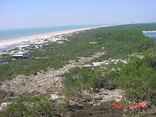
The Big Bend Coastal Marsh is an extremely narrow but long region, following the Gulf coast beginning near the mouth of the Ochlockonee River (near 29° 45' N, 85° W), until just north of Tampa Bay (near 28° 14' N, 82° 45' W), a distance of approximately 280 miles (450 km), but typically penetrating only 0.5 to 1.5 miles (0.80 to 2.41 km) inland from the shore. The Big Bend marsh constitutes "the largest remaining stretch of undeveloped coastline in the continental United States" [15] as well as "the second-largest contiguous seagrass meadow in the continental United States." [16] A karst shelf is layered over with poorly draining organic soil. The Suwanee River is the largest contributor of freshwater to the ecoregion, with a discharge volume of 9460 million cubic meters, roughly 82% of freshwater inflow. [15] [16]

The marsh is dominated by seagrass es, namely turtlegrass, manateegrass, and shoalgrass, with occasional stargrass, widgeongrass, and paddlegrass. [16] Oyster reefs are present in some areas and act as a food source for shorebirds such as American oystercatchers. [17]

The Big Bend Coastal Marsh generally transitions to the Gulf Coast Flatwoods (75a), which may be piney forest or swamp depending on inflow of freshwater and soil drainage. Adjacent swamps, and the coastal marsh in general, are very sensitive to tidal flooding (and baseline sea level rise), saltwater intrusion, aquatic pollution, tropical cyclones, and cold snaps (whose frequency has increased due to anthropogenic climate change). Authors of a 2018 satellite-imagery-based study characterized regional forests' status as experiencing "accelerated die-off." [15] Authors of a 15-year seagrass study which concluded in 2022 characterized Southern Big Bend's 45% decline in seagrass cover as "alarming." [16]

Related Research Articles

<span class="mw-page-title-main">Swamp</span> A forested wetland

A swamp is a forested wetland. Swamps are considered to be transition zones because both land and water play a role in creating this environment. Swamps vary in size and are located all around the world. The water of a swamp may be fresh water, brackish water, or seawater. Freshwater swamps form along large rivers or lakes where they are critically dependent upon rainwater and seasonal flooding to maintain natural water level fluctuations. Saltwater swamps are found along tropical and subtropical coastlines. Some swamps have hammocks, or dry-land protrusions, covered by aquatic vegetation, or vegetation that tolerates periodic inundation or soil saturation. The two main types of swamp are "true" or swamp forests and "transitional" or shrub swamps. In the boreal regions of Canada, the word swamp is colloquially used for what is more formally termed a bog, fen, or muskeg. Some of the world's largest swamps are found along major rivers such as the Amazon, the Mississippi, and the Congo.

<span class="mw-page-title-main">Okefenokee Swamp</span> Wetlands in Florida and Georgia, USA

The Okefenokee Swamp is a shallow, 438,000-acre (177,000 ha), peat-filled wetland straddling the Georgia–Florida line in the United States. A majority of the swamp is protected by the Okefenokee National Wildlife Refuge and the Okefenokee Wilderness. The Okefenokee Swamp is considered to be one of the Seven Natural Wonders of Georgia and is the largest "blackwater" swamp in North America.

<span class="mw-page-title-main">Piney Woods</span> Temperate coniferous forests ecoregion of the United States

The Piney Woods is a temperate coniferous forest terrestrial ecoregion in the Southern United States covering 54,400 square miles (141,000 km2) of East Texas, southern Arkansas, western Louisiana, and southeastern Oklahoma. These coniferous forests are dominated by several species of pine as well as hardwoods including hickory and oak. Historically the most dense part of this forest region was the Big Thicket though the lumber industry dramatically reduced the forest concentration in this area and throughout the Piney Woods during the 19th and 20th centuries. The World Wide Fund for Nature considers the Piney Woods to be one of the critically endangered ecoregions of the United States. The United States Environmental Protection Agency (EPA) defines most of this ecoregion as the South Central Plains.

<span class="mw-page-title-main">Myakka River State Park</span> State park in Florida, United States

Myakka River State Park is a Florida State Park, that is located nine miles (14 km) east of Interstate 75 in Sarasota County and a portion of southeastern Manatee County on the Atlantic coastal plain. This state park consists of 37,000 acres (150 km2), making it one of the state's largest parks. It is also one of the oldest parks in the state. It was delineated in the 1930s by the Civilian Conservation Corps. A small portion of the park was the gift of the family of Bertha Palmer to the state. The park is named after the Myakka River.

<span class="mw-page-title-main">Apalachicola National Forest</span> A national forest located Florida

The Apalachicola National Forest is the largest U.S. National Forest in the state of Florida. It encompasses 632,890 acres and is the only national forest located in the Florida Panhandle. The National Forest provides water and land-based outdoors activities such as off-road biking, hiking, swimming, boating, hunting, fishing, horse-back riding, and off-road ATV usage.

<span class="mw-page-title-main">Western Gulf coastal grasslands</span> Subtropical grassland ecoregion of Mexico and the United States

The Western Gulf coastal grasslands are a subtropical grassland ecoregion of the southern United States and northeastern Mexico. It is known in Louisiana as the "Cajun Prairie", Texas as "Coastal Prairie," and as the Tamaulipan pastizal in Mexico.

<span class="mw-page-title-main">Okefenokee National Wildlife Refuge</span> Nature center in Folkston, Georgia, USA

The Okefenokee National Wildlife Refuge is a 402,000‑acre (1,627 km2) National Wildlife Refuge located in Charlton, Ware, and Clinch Counties of Georgia, and Baker County in Florida, United States. The refuge is administered from offices in Folkston, Georgia. The refuge was established in 1937 to protect a majority of the 438,000 acre (1,772 km2) Okefenokee Swamp. Though often translated as "land of trembling earth", the name "Okefenokee" is likely derived from Hitchiti oki fanôːki "bubbling water".

<span class="mw-page-title-main">Hammock (ecology)</span> Type of ecosystem in the southeastern United States

Hammock is a term used in the southeastern United States for stands of trees, usually hardwood, that form an ecological island in a contrasting ecosystem. Hammocks grow on elevated areas, often just a few inches high, surrounded by wetlands that are too wet to support them. The term hammock is also applied to stands of hardwood trees growing on slopes between wetlands and drier uplands supporting a mixed or coniferous forest. Types of hammocks found in the United States include tropical hardwood hammocks, temperate hardwood hammocks, and maritime or coastal hammocks. Hammocks are also often classified as hydric, mesic or xeric. The types are not exclusive, but often grade into each other.

<span class="mw-page-title-main">Florida Trail</span> A US National Scenic trail

The Florida Trail is one of eleven National Scenic Trails in the United States, created by the National Trails System Act of 1968. It runs 1,500 miles (2,400 km), from Big Cypress National Preserve to Fort Pickens at Gulf Islands National Seashore, Pensacola Beach. Also known as the Florida National Scenic Trail, the trail provides permanent non-motorized recreation for hiking and other compatible activities within an hour of most floridians.

<span class="mw-page-title-main">Atlantic Plain</span> Physiographic division of the United States

The Atlantic Plain is one of eight distinct physiographic divisions of the contiguous United States. Using the USGS physiographic classification system, the Atlantic Plain division comprises two provinces and six sections. The Coastal Plain province is differentiated from the Continental Shelf province simply based on the portion of the land mass above and below sea level.

<span class="mw-page-title-main">Florida scrub</span> Ecoregion of Florida, United States

Florida scrub is a forest ecoregion found throughout Florida in the United States. It is found on coastal and inland sand ridges and is characterized by an evergreen xeromorphic plant community dominated by shrubs and dwarf oaks. Because the low-nutrient sandy soils do not retain moisture, the ecosystem is effectively an arid one. Wildfires infrequently occur in the Florida scrub. Most of the annual rainfall falls in summer.

<span class="mw-page-title-main">Coast Range (EPA ecoregion)</span> Coastal ecoregion in the Western United States

The Coast Range ecoregion is a Level III ecoregion designated by the Environmental Protection Agency (EPA) in the U.S. states of Washington, Oregon, and California. It stretches along the Pacific Coast from the tip of the Olympic Peninsula in the north to the San Francisco Bay in the south, including Grays Harbor, Willapa Bay, and the Long Beach Peninsula in Washington, the entire length of the Oregon Coast, and the Northern California Coast. Named for the Coast Range mountains, it encompasses the lower elevations of the Olympic Mountains, the Oregon Coast Range, the Californian North Coast Ranges, and surrounding lowlands.

<span class="mw-page-title-main">East Central Texas forests</span> Temperate broadleaf and mixed forests ecoregion of Oklahoma and Texas, United States

The East Central Texas forests or East Central Texas Plains (33) is a small temperate broadleaf and mixed forests ecoregion almost entirely within the state of Texas, United States. The northern forests perimeter is partially within the southeast Oklahoma border.

<span class="mw-page-title-main">Middle Atlantic coastal forests</span> Temperate coniferous forests ecoregion of the United States

The Middle Atlantic coastal forests are a temperate coniferous forest mixed with patches of evergreen broadleaved forests along the coast of the southeastern United States.

<span class="mw-page-title-main">Southeastern conifer forests</span> Temperate coniferous forests ecoregion of the United States

The Southeastern conifer forests are a temperate coniferous forest ecoregion of the southeastern United States. It is the largest conifer forest ecoregion east of the Mississippi River. It is also the southernmost instance of temperate coniferous forest within the Nearctic realm.

The Mississippi Alluvial Plain is a Level III ecoregion designated by the Environmental Protection Agency (EPA) in seven U.S. states, though predominantly in Arkansas, Louisiana, and Mississippi. It parallels the Mississippi River from the Midwestern United States to the Gulf of Mexico.

<span class="mw-page-title-main">Arkansas Valley (ecoregion)</span> EPA Level III ecoregion

The Arkansas Valley is a Level III ecoregion designated by the Environmental Protection Agency (EPA) in the U.S. states of Arkansas and Oklahoma. It parallels the Arkansas River between the flat plains of western Oklahoma and the Arkansas Delta, dividing the Ozarks and the Ouachita Mountains with the broad valleys created by the river's floodplain, occasionally interrupted by low hills, scattered ridges, and mountains. In Arkansas, the region is often known as the Arkansas River Valley, especially when describing the history and culture of the region.

<span class="mw-page-title-main">Southeastern Plains (ecoregion)</span> Level III ecoregion in the United States

The North American Southeastern Plains are a Level III ecoregion designated by the Environmental Protection Agency (EPA) in ten U.S. states. The region takes a U shape starting in western Tennessee, going south through eastern Mississippi, and forming most of Alabama. On the eastern side, the plains lie between the Appalachian Mountains and the coastal plains, forming central Georgia, South Carolina, and North Carolina. It forms part of eastern Virginia before terminating in Maryland.

<span class="mw-page-title-main">Mississippi Valley Loess Plains (ecoregion)</span> Level III ecoregion in the United States

The North American Mississippi Valley Loess Plains are a Level III ecoregion designated by the Environmental Protection Agency (EPA) in six U.S. states. The region lies primarily on the eastern border of the Mississippi Alluvial Plain, from the Ohio River in western Kentucky, through Tennessee and Mississippi, to Louisiana. A separate unit that includes Crowley's Ridge occurs west of the river in Arkansas and Missouri. It has been divided into four Level IV ecoregions.

References

  1. 1 2 3 4 5 6 7 Griffith, Glenn (2010-05-11). "Level III North American Terrestrial Ecoregions: United States Descriptions". United States Environmental Protection Agency . Retrieved 2023-03-12.PD-icon.svg This article incorporates text from this source, which is in the public domain .
  2. Beck, Hylke E.; Zimmermann, Niklaus E.; McVicar, Tim R.; Vergopolan, Noemi; Berg, Alexis; Wood, Eric F. (2018-10-30). "Present and future Köppen-Geiger climate classification maps at 1-km resolution". Scientific Data. 5 (1). Bibcode:2018NatSD...580214B. doi:10.1038/sdata.2018.214. ISSN   2052-4463. PMC   6207062 . PMID   30375988.
  3. "NOWData - NOAA Online Weather Data". National Weather Service . Retrieved 2024-03-21.
  4. 1 2 3 4 5 6 7 8 9 10 Griffith, Glenn E.; Omernik, James M.; Comstock, Jeffrey A.; Lawrence, Steve; Martin, George; Goddard, Art; Hulcher, Vickie J.; Foster, Trish (2001). "Ecoregions of Alabama and Georgia" (PDF). United States Environmental Protection Agency . Retrieved 2024-03-12.
  5. "Pine Flatwoods". University of Florida, Institute of Food and Agricultural Sciences. Retrieved 2024-03-15.
  6. "Withlacoochee State Forest". Florida Department of Agriculture and Consumer Services . Retrieved 2024-03-15.
  7. 1 2 3 4 5 6 7 Weekley, Carl W.; Menges, Eric S.; Pickert, Roberta L (Winter 2008). "An Ecological Map of Florida's Lake Wales Ridge: A New Boundary Delineation and an Assessment of Post-Columbian Habitat Loss". Florida Scientist. 71 (1): 45–64. JSTOR   24321468 via JSTOR.
  8. "Okaloacoochee Slough State Forest". Florida Department of Agriculture and Consumer Services . Retrieved 2024-03-15.
  9. 1 2 3 Mushinsky, Henry R.; McCoy, Earl D. (2017). "Partners in Three Decades of Conservation Research in Florida". Journal of Herpetology . 51 (3): 287–296. doi:10.1670/16-015 via JSTOR.
  10. Abrahamson, Warren G.; Layne, James N. (2003). "Long-term Patterns of Acorn Production for Five Oak Species in Xeric Florida Uplands". Ecology . 84 (9): 2476–2492. Bibcode:2003Ecol...84.2476A. doi:10.1890/01-0707.
  11. "Conradina etonia". NatureServe Explorer. Retrieved 2024-03-15.
  12. "St. Johns National Wildlife Refuge". United States Fish and Wildlife Service . Retrieved 2024-03-15.PD-icon.svg This article incorporates text from this source, which is in the public domain .
  13. 1 2 3 4 Griffith, Glenn; Omernik, James; Comstock, Jeffrey (2002-07-31). "Ecoregions of South Carolina: Regional Descriptions". United States Environmental Protection Agency .
  14. Daigle, Jerry J.; Griffith, Glenn E.; Omernik, James M.; Faulkner, Patricia L.; McCulloh, Richard P.; Handley, Lawrence R.; Smith, Latimore M.; Chapman, Shannen S. (2006). "Ecoregions of Louisiana" (PDF). Retrieved 2024-03-12.PD-icon.svg This article incorporates text from this source, which is in the public domain .
  15. 1 2 3 McCarthy, Matthew; Dimmitt, Benjamin; Muller-Karger, Frank (2018-10-31). "Rapid Coastal Forest Decline in Florida's Big Bend". Remote Sensing. 10 (11): 1721. Bibcode:2018RemS...10.1721M. doi: 10.3390/rs10111721 . ISSN   2072-4292.
  16. 1 2 3 4 Yarbro, L. A.; Carlson, P. R.; Johnsey, E. (2023-12-16). "Extensive and Continuing Loss of Seagrasses in Florida's Big Bend (USA)". Environmental Management. 73 (4): 876–894. Bibcode:2023EnMan..73..876Y. doi:10.1007/s00267-023-01920-y. ISSN   0364-152X. PMID   38103093.
  17. Vitale, Nick; Brush, Janell; Powell, Abby (June 2021). "Loss of Coastal Islands Along Florida's Big Bend Region: Implications for Breeding American Oystercatchers". Estuaries and Coasts. 44 (4): 1173–1182. Bibcode:2021EstCo..44.1173V. doi:10.1007/s12237-020-00811-3. ISSN   1559-2723.