Stupnica Ступница | |
---|---|
Village | |
Coordinates: 43°04′58″N22°07′18″E / 43.08278°N 22.12167°E | |
Country | |
District | Jablanica District |
Municipality | Leskovac |
Population (2002) | |
• Total | 402 |
Time zone | CET (UTC+1) |
• Summer (DST) | CEST (UTC+2) |
Stupnica is a village in the municipality of Leskovac, Serbia. According to the 2002 census, the village has a population of 402 people. [1]
A village is a clustered human settlement or community, larger than a hamlet but smaller than a town, with a population ranging from a few hundred to a few thousand. Though villages are often located in rural areas, the term urban village is also applied to certain urban neighborhoods. Villages are normally permanent, with fixed dwellings; however, transient villages can occur. Further, the dwellings of a village are fairly close to one another, not scattered broadly over the landscape, as a dispersed settlement.
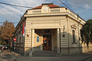
Leskovac is a city and the administrative center of the Jablanica District in southern Serbia. According to the 2011 census, the city urban area has 60,288 inhabitants, while the city administrative area has 144,206.
Serbia, officially the Republic of Serbia, is a country situated at the crossroads of Central and Southeast Europe in the southern Pannonian Plain and the central Balkans. The sovereign state borders Hungary to the north, Romania to the northeast, Bulgaria to the southeast, North Macedonia to the south, Croatia and Bosnia and Herzegovina to the west, and Montenegro to the southwest. The country claims a border with Albania through the disputed territory of Kosovo. Serbia's population is about seven million. Its capital, Belgrade, ranks among the oldest and largest citiеs in Europe.
Bolatice is a village in the Moravian-Silesian Region of the Czech Republic. It is part of micro-region Hlučínsko. It has around 4,200 inhabitants.
Twin Lakes is a census-designated place located in Lake County, Colorado, United States near the base of Mount Elbert. The population as of the 2010 Census was 171. Twin Lakes has the ZIP Code 81251.
Dəvədaşı is a village in the Kalbajar Rayon of Azerbaijan.
Otaqlı is a village in the Kalbajar Rayon of Azerbaijan.
Elżbieta-Kolonia is a village in the administrative district of Gmina Opole Lubelskie, within Opole Lubelskie County, Lublin Voivodeship, in eastern Poland.
Mollalar is a village in the Agdam Rayon of Azerbaijan.
Święta is a village in the administrative district of Gmina Złotów, within Złotów County, Greater Poland Voivodeship, in west-central Poland. It lies approximately 4 kilometres (2 mi) south-east of Złotów and 105 km (65 mi) north of the regional capital Poznań.
Świerzenko is a village in Gmina Miastko, Bytów County, Pomeranian Voivodeship, in northern Poland. It lies approximately 26 kilometres (16 mi) south-west of Bytów and 75 km (47 mi) south-west of Gdańsk.
Kopina is a village in the administrative district of Gmina Pasłęk, within Elbląg County, Warmian-Masurian Voivodeship, in northern Poland.
Połczyno is a village in the administrative district of Gmina Lipiany, within Pyrzyce County, West Pomeranian Voivodeship, in north-western Poland.
Tân Hoà is a commune (xã) and village in Tân Thành District, Bà Rịa–Vũng Tàu Province, in Vietnam.
Ćukovac is a village in the municipality of Bojnik, Serbia. According to the 2002 census, the village has a population of 122 people.
Glogovica is a village in the municipality of Zaječar, Serbia. According to the 2002 census, the village has a population of 484 people.
Mala Jasikova is a village in the municipality of Zaječar, Serbia. According to the 2002 census, the village has a population of 332 people.
Kantküla is a village in Kose Parish, Harju County in northern Estonia.
Kuijõe is a village in Lääne-Nigula Parish, Lääne County, in western Estonia.
Hodinići is a village in the municipality of Trebinje, Republika Srpska, Bosnia and Herzegovina.
Käbiküla is a village in Märjamaa Parish, Rapla County in western Estonia.
Reževiće is a village in the municipality of Tutin, Serbia. According to the 2002 census, the village has a population of 104 people.
Ban Dara Junction is a railway station located in Phichai District, Uttaradit. It is a Class 3 Station and serves as a junction for the Sawankhalok Branch. Ban Dara Junction is located 438.31 kilometres (272.35 mi) from Bangkok Railway Station. It is also the nearest station to Poramin Railway Bridge.
Coordinates: 43°04′58″N22°07′18″E / 43.08278°N 22.12167°E
A geographic coordinate system is a coordinate system that enables every location on Earth to be specified by a set of numbers, letters or symbols. The coordinates are often chosen such that one of the numbers represents a vertical position and two or three of the numbers represent a horizontal position; alternatively, a geographic position may be expressed in a combined three-dimensional Cartesian vector. A common choice of coordinates is latitude, longitude and elevation. To specify a location on a plane requires a map projection.
This Jablanica District, Serbia location article is a stub. You can help Wikipedia by expanding it. |