Swan River | |
---|---|
Town | |
Town of Swan River | |
![]() Town boundaries | |
Coordinates: 52°06′21″N101°16′00″W / 52.10583°N 101.26667°W | |
Country | Canada |
Province | Manitoba |
Region | Parkland |
Incorporated | 1908 |
Government | |
• Mayor | Lance Jacobson |
• MLA (Swan River) | Rick Wowchuk (PC) |
• MP (Dauphin—Swan River—Neepawa) | Dan Mazier (CPC) |
Area | |
• Total | 7.16 km2 (2.76 sq mi) |
• Population Centre | 6.81 km2 (2.63 sq mi) |
Population | |
• Total | 4,049 |
• Density | 595/km2 (1,540/sq mi) |
• Population Centre | 3,989 |
• Population Centre density | 633.7/km2 (1,641/sq mi) |
Website | swanrivermanitoba.ca |
Swan River is a town in Manitoba, Canada. It is surrounded by the Municipality of Swan Valley West in the Swan River Valley region. According to the 2021 Canadian Census, Swan River had a population of 4,049, making it Manitoba's 18th largest in population.
Located in a valley between the Duck Mountains and the Porcupine Hills, the town of Swan River is close to the Saskatchewan boundary in west-central Manitoba.
The town is situated along the Swan River which flows into Swan Lake, 55 km (34 mi) to the north-east. Swan Lake is believed to be named for trumpeter swans that once bred near the lake, but are now locally extirpated. Henry Kelsey became the first European explorer to visit the area in 1690. The name of the lake is first noted on a map created by Peter Fidler in 1795 and again on a French map in 1802 (as L du Cigne). The first permanent European settlement dates back to 1770, when fur traders from both the Hudson's Bay Company and the North West Company established outposts along the Swan River where they bought and sold goods to local Cree peoples by way of birch bark canoes.
In 1876, the musical band of the North-West Mounted Police, the forerunner of the Royal Canadian Mounted Police, made its debut in what was later to become Swan River. The instruments used in the band were purchased by the 20 officers in the band and shipped from Winnipeg by dog sled.
The first pioneers arrived in the Swan Valley through the Duck Mountains in 1897 and quickly developed the farming potential of the area. The proposed construction of a line of the Canadian Northern Railway was announced in 1898 and the town was founded in 1900, though it was little more than a post office at the time. Swan River was officially incorporated as a town in 1908.
In the 2021 Census of Population conducted by Statistics Canada, Swan River had a population of 4,049 living in 1,825 of its 2,020 total private dwellings, a change of 0.9% from its 2016 population of 4,014. With a land area of 6.81 km2 (2.63 sq mi), it had a population density of 594.6/km2 (1,539.9/sq mi) in 2021. [3]
The Swan River Valley is not truly a river valley, but is instead a western extension of the Manitoba lowlands into the Manitoba Escarpment. The Valley is surrounded by escarpment features on three sides: the Duck Mountains to the south; the Porcupine Hills to the north; and Thunder Hill to the west. To the east is Lake Winnipegosis, which is a modern remnant of glacial Lake Agassiz, a lake that filled the valley after the last ice age (the valley was then a bay on the western shore of the lake).
Valley soils are formed from a mixture of glacial till and lacustrine clay. Sandy beach ridges (marking the western shore of Lake Agassiz at various times) lie throughout the area: a prominent beach ridge lies under the town's golf course, just west of town. Valley soils are typically very fertile and deep, and are the area's greatest natural resource. But they also have a high calcium carbonate content and an alkaline pH, which limits their productivity in some crops (for example, blueberries).
The underlying bedrock is composed of Cretaceous shales, and, below that, sandstone, which overlie deeper deposits of Devonian limestone, which in turn overlie Precambrian granite. [5]
The Swan River Valley is near the southern limit of the boreal forest in its transition zone to aspen parkland. Valley trees include white spruce, black spruce, tamarack larch, balsam fir, jack pine, quaking aspen, balsam poplar, and paper birch. Most of the forest has been cleared from the flat valley bottom for agricultural purposes, but the surrounding hills are still heavily forested, and are designated as forest reserves.
Numerous peaty bogs and wetlands are present in the area, including hundreds of oxbow lakes of the meandering Swan and Woody rivers. The surrounding hills have many lakes, as does the lower lake bottom land near the eastern edge of the valley.
The climate of west-central Manitoba features extreme seasonal variation, with winter temperatures below −30 °C (−22 °F) and summer temperatures above 30 °C (86 °F) not uncommon. The town therefore has very distinct seasons. Snow usually covers the ground from early November to early April, and only two Christmases have been recorded that have not been "white" (snow-covered) since such records have been kept. The transition from winter to spring to summer is rapid, with the snow of late March turning to the full green of summer by mid-May. The onset of autumn, then winter, is equally rapid, as daytime high temperatures above 20 °C (68 °F) are common in late September, while temperatures above freezing are rare by early November, only seven weeks later. Summer, although short, is pleasant and very green, owing to the fertility of local soils and adequate rainfall.
Most precipitation falls as rain in the summer - usually in brief thunderstorms - or in less violent but more protracted snow or rainshowers in spring and fall. Little precipitation falls in winter because the air is then too cold to hold significant amounts of moisture. However, because the temperature rarely goes above the melting point of water in winter, what precipitation that does fall falls as snow, and accumulates on the ground, building to a depth of about 45 cm (18 in) before finally starting to melt in March.
Climate data for Swan River, 52°03′N101°13′W / 52.050°N 101.217°W , 346.6 m (1,137 ft) | |||||||||||||
---|---|---|---|---|---|---|---|---|---|---|---|---|---|
Month | Jan | Feb | Mar | Apr | May | Jun | Jul | Aug | Sep | Oct | Nov | Dec | Year |
Record high °C (°F) | 8.5 (47.3) | 12.0 (53.6) | 20.6 (69.1) | 32.2 (90.0) | 39.0 (102.2) | 38.9 (102.0) | 37.8 (100.0) | 38.3 (100.9) | 37.8 (100.0) | 30.6 (87.1) | 20.0 (68.0) | 11.1 (52.0) | 39.0 (102.2) |
Mean daily maximum °C (°F) | −12.2 (10.0) | −7.8 (18.0) | −0.7 (30.7) | 9.1 (48.4) | 17.0 (62.6) | 21.9 (71.4) | 24.3 (75.7) | 23.7 (74.7) | 17.5 (63.5) | 9.5 (49.1) | −2.2 (28.0) | −9.9 (14.2) | 7.5 (45.5) |
Daily mean °C (°F) | −17.2 (1.0) | −13.0 (8.6) | −6.2 (20.8) | 3.1 (37.6) | 10.3 (50.5) | 15.5 (59.9) | 18.1 (64.6) | 17.1 (62.8) | 11.3 (52.3) | 4.2 (39.6) | −6.3 (20.7) | −14.6 (5.7) | 1.8 (35.2) |
Mean daily minimum °C (°F) | −22.2 (−8.0) | −18.1 (−0.6) | −11.8 (10.8) | −3.0 (26.6) | 3.6 (38.5) | 9.0 (48.2) | 11.7 (53.1) | 10.3 (50.5) | 5.2 (41.4) | −1.2 (29.8) | −10.5 (13.1) | −19.2 (−2.6) | −3.9 (25.0) |
Record low °C (°F) | −46.1 (−51.0) | −43.9 (−47.0) | −38.0 (−36.4) | −28.3 (−18.9) | −15.6 (3.9) | −5.0 (23.0) | −0.5 (31.1) | −4.4 (24.1) | −12.2 (10.0) | −20.6 (−5.1) | −36.0 (−32.8) | −45.6 (−50.1) | −46.1 (−51.0) |
Average precipitation mm (inches) | 22.4 (0.88) | 16.4 (0.65) | 24.5 (0.96) | 34.7 (1.37) | 54.1 (2.13) | 85.4 (3.36) | 95.6 (3.76) | 76.8 (3.02) | 53.4 (2.10) | 33.7 (1.33) | 25.1 (0.99) | 24.4 (0.96) | 546.6 (21.52) |
Average rainfall mm (inches) | 0.2 (0.01) | 0.5 (0.02) | 6.9 (0.27) | 18.7 (0.74) | 50.7 (2.00) | 85.4 (3.36) | 95.6 (3.76) | 76.8 (3.02) | 52.8 (2.08) | 26.5 (1.04) | 3.1 (0.12) | 0.7 (0.03) | 417.8 (16.45) |
Average snowfall cm (inches) | 22.2 (8.7) | 16 (6.3) | 17.6 (6.9) | 16.1 (6.3) | 3.4 (1.3) | 0 (0) | 0 (0) | 0 (0) | 0.6 (0.2) | 7.2 (2.8) | 22 (8.7) | 23.8 (9.4) | 128.8 (50.7) |
Average precipitation days (≥ 0.2 mm) | 9.3 | 6.9 | 7.4 | 8.7 | 11.7 | 15.1 | 14.6 | 12.8 | 11.7 | 9.9 | 7.6 | 8.4 | 124 |
Average rainy days (≥ 0.2 mm) | 0.13 | 0.36 | 2.1 | 6.1 | 11.3 | 15.1 | 14.6 | 12.8 | 11.6 | 8.6 | 1.3 | 0.17 | 84.1 |
Average snowy days (≥ 0.2 cm) | 9.1 | 6.6 | 6 | 3.4 | 0.57 | 0 | 0 | 0 | 0.21 | 1.8 | 6.5 | 8.4 | 42.4 |
Source: [6] |
The economic base of the town lies in agriculture and forestry along with support industries for same.
Almost fifty percent of the surrounding area is under cultivation, most of which is seeded to cereal grain, oilseeds, and other speciality crops. Wheat, rye, barley, oats, flax, and rapeseed are the primary grain crops, while other commercial crops include potatoes and strawberries. There are also many mixed farms producing cattle, pigs, and farm-raised wild animals.
Softwood lumber trees (primarily white spruce) are cut from the surrounding forests, and milled at Spruce Products Ltd. Also, east of Swan River is located a mill specializing in the production of oriented strand board from aspen and balsam poplar. It is owned by Louisiana-Pacific.
Other major industries of the town are health care, retail services, manufacturing, and tourism.
The town of Swan River acts as a hub for an area of approximately 8,000 people.
The primary healthcare centre in the Swan River Valley is the Swan Valley Health Centre, located in downtown Swan River. The 52 acute-care bed facility was opened in 2005 to replace the old Swan River Valley Hospital, which closed in 2001. Between 2001–2005, the Swan River Valley Hospital was located in a temporary structure adjacent to the old hospital. Services at the hospital include in-patient medical/surgical services, out-patient services, mental health services, and occupational therapy. The hospital is also home to the only emergency department in the Swan River Valley.
The town is served by Manitoba Provincial Highways PTH 10, PTH 10A, PTH 83, and PTH 83A. Until recently, PTH 10 and PTH 83 came directly into Swan River, with the intersection located near the town's southwestern corner. The completion of a new bypass changed the highway to start on the east side of Swan River. PTH 83 continues south to the Canada–US border near Westhope, North Dakota. It then continues south as U.S. Route 83 to the Mexican border near Brownsville, Texas, making it the longest continuously numbered north-south highway in North America, with a combined distance of 3,450 km (2,140 mi).
Swan River Airport has no scheduled flights and is used by charter services, emergency flights and private pilots. Up until the mid 2000s, the Swan River Airport had scheduled flights to Dauphin and the Winnipeg James Armstrong Richardson International Airport in Winnipeg.[ citation needed ]
Public schools in Swan River are governed by the Swan Valley School Division #35. There are 7 public schools in the Swan Valley, four of which are in the town of Swan River.
Campus Manitoba, Assiniboine Community College, and University College of the North offer a variety of courses and programs in Swan River.
The Northern Lights Institute of Trades & Technology (through the SVRSS) offers training in job-ready skills and trades through the Swan Valley School Division.[ citation needed ]
There are a number of churches in the Swan Valley area
Swan River hosts the annual Northwest Round-up and Exhibition on the last weekend of July. The Northwest Round-up and Exhibition, which is hosted by the Agricultural Society, includes a parade, chariot and chuck wagon races, heavy and light horse shows, talent stages, concerts, dances, home living and school work exhibits, a midway, and the rodeo, which features events like the heavy horse pull, barrel racing, calf roping, and bull riding.
Geographical Names of Manitoba, National Library of Canada, ISBN 0-7711-1517-2, 2005
Dauphin is a city in Manitoba, Canada, with a population of 8,368 as of the 2021 Canadian Census. The community is surrounded by the Rural Municipality of Dauphin. The city takes its name from Lake Dauphin and Fort Dauphin, which were named by explorer Pierre Gaultier de La Vérendrye in honour of the Dauphin of France, the heir to the French throne. Dauphin is Manitoba's ninth largest community and serves as a hub to the province's Parkland Region.
Steinbach is the third-largest city in the province of Manitoba, Canada, and with a population of 17,806, the largest community in the Eastman region. The city, located about 58 km (36 mi) southeast of the provincial capital of Winnipeg, is bordered by the Rural Municipality of Hanover to the north, west, and south, and the Rural Municipality of La Broquerie to the east. Steinbach was first settled by Plautdietsch-speaking Mennonites from Ukraine in 1874, whose descendants continue to have a significant presence in the city today. Steinbach is found on the eastern edge of the Canadian Prairies, while Sandilands Provincial Forest is a short distance east of the city.
The Westman Region is an informal geographic region of the Canadian province of Manitoba located in the southwestern corner of the province.
Winkler is a city in Manitoba, Canada with a population of 13,745, making it the 4th largest city in Manitoba, as of the 2021 Canadian census. It is located in southern Manitoba, surrounded by the Rural Municipality of Stanley, about one hundred kilometres southwest of Winnipeg and 13 km (8.1 mi) east of its "twin city" Morden. As the largest city in the Pembina Valley, it serves as a regional hub for commerce, agriculture and industry. Winkler is the third-fastest growing city in the province after Morden and Steinbach.
Minnedosa is a town in the southwestern part of the Canadian province of Manitoba situated 50 kilometres (32 mi) north of Brandon, Manitoba on the Little Saskatchewan River. The town's name means "flowing water" in the Dakota language. The population of Minnedosa reported in the 2021 Canadian Census was 2,741. The town is surrounded by the Rural Municipality of Minto – Odanah.
Snow Lake is a town in Manitoba, Canada, located 685 km north of Winnipeg at the end of Provincial Road 392. The main industry is, and always has been, mining; currently with one mine producing Zinc, and another lithium. The official Town of Snow Lake is a very large, overwhelmingly rural area that is centered about the urban community of Snow Lake, which lies very near its geographical center. The Town is as large in area as a typical rural municipality in the more southern parts of Manitoba.
Morris is a small town in the Pembina Valley region of Manitoba, Canada, located 51 km south of Winnipeg and 42 km north of Emerson. Morris is home to 1,885 people (2016). The town is named after Alexander Morris, the second Lieutenant Governor of Manitoba.
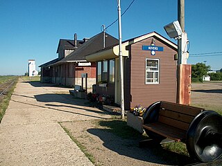
Rivers is an unincorporated urban community in the Riverdale Municipality within the Canadian province of Manitoba. It is located 40 kilometres (25 mi) northwest of Brandon, 473 metres (1,552 ft) above sea level. It is within the Westman Region. Agriculture, health and related businesses provide income for the community and area. Rivers has a population of 1,257 people in the 2016 census.
Lion's Head is a community in the municipality of Northern Bruce Peninsula, Bruce County, Ontario, Canada. It is located at the midway point of the Bruce Peninsula, about halfway between Owen Sound and Tobermory, just east of Ferndale on Bruce Road 9. Lion's Head is located on the 45th parallel north, halfway between the Equator and the North Pole. The town is named after the resemblance of a lion's profile in the rock formation of the Niagara Escarpment. The first post office opened in 1895.
Neepawa is a town in Manitoba, Canada, on the Yellowhead Highway at the intersection with Highway 5.
Stonewall is a town in the Canadian province of Manitoba with a population of 5,046 as of the 2021 census. The town is situated approximately 25 kilometres (16 mi) north of Winnipeg on PTH 67. It is known for its limestone quarries. The local festival is the Quarry Days which is usually held over three days in August on Main Street. The town is surrounded by the R.M. of Rockwood.
Oak Lake is an unincorporated urban community in the Rural Municipality of Sifton within the Canadian province of Manitoba that held town status prior to January 1, 2015. It is located 52 km (32 mi) west of Brandon along the Trans-Canada Highway. The lake after which it was named is in the rural municipality's western area.
Ste. Anne, or Sainte-Anne-des-Chênes, is a town in Manitoba, Canada, located about 42 km southeast of Winnipeg. The population was 2,114 in 2016, 1,524 in 2011, and 1,513 in 2011. It is known for being located on the Seine River and at the heart of the Old Dawson Trail. The town is surrounded by the Rural Municipality of Ste. Anne.
Minitonas is an unincorporated urban community in the Municipality of Minitonas – Bowsman, Manitoba, Canada. It is surrounded by the Swan Valley and is located 15 km east of the Town of Swan River. The community is close to the Duck Mountain Provincial Park.
The Manitoba Escarpment, or the Western Manitoba Uplands, are a range of hills along the Saskatchewan–Manitoba border. The eastern slopes of the range are considered to be a scarp. They were created by glacial scouring and formed the western shore of prehistoric Lake Agassiz.
Highway 49 and Provincial Trunk Highway 49 is a provincial highway in the Canadian provinces of Saskatchewan and Manitoba. Most of the highway is in the east-central part of Saskatchewan and only a very short section is in Manitoba. It runs from Saskatchewan Highway 35 between the communities of Fosston and Hendon to the Saskatchewan — Manitoba border, before ending at Provincial Trunk Highway 83 south of the community of Benito. The combined highway is about 166.4 kilometres (103.4 mi) in length — 165.2 kilometres (102.7 mi) is in Saskatchewan and 1.2 kilometres (0.7 mi) is in Manitoba.
Swan River is located in the Canadian provinces of Manitoba and Saskatchewan. The river, and several other features in the area, are named after the trumpeter swans found in the region.
The Mid-Canada Boreal Plains Forests is a taiga ecoregion of Western Canada, designated by One Earth. It was previously defined as the Mid-Continental Canadian Forests by the World Wildlife Fund (WWF) categorization system, before it was modified by One Earth, the successor to WWF.
Grandview Municipality is a rural municipality (RM) in the Parkland Region of Manitoba, Canada. It is located in a valley between Duck Mountain Provincial Forest & Park and Riding Mountain National Park, which both lie partially within the RM's territory.
Oak Bluff is an incorporated community located in the Rural Municipality of Macdonald, Manitoba, Canada. It is situated seven kilometres southwest of the City of Winnipeg, between Manitoba Highway (PTH) 3's intersections with PTH 2 and PTH 100. The community has a population of 1,442 as of the 2021 Canadian census