Almè is a comune (municipality) in the Province of Bergamo in the Italian region Lombardy, located about 45 kilometres (28 mi) northeast of Milan and about 5 kilometres (3 mi) northwest of Bergamo.
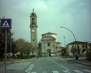
Almenno San Bartolomeo is a comune (municipality) in the Province of Bergamo in the Italian region Lombardy, located about 45 kilometres (28 mi) northeast of Milan and about 9 kilometres (6 mi) northwest of Bergamo.

Almenno San Salvatore is a comune (municipality) in the Province of Bergamo in the Italian region Lombardy, located about 45 kilometres (28 mi) northeast of Milan and about 9 kilometres (6 mi) northwest of Bergamo.

Arzago d'Adda is a comune (municipality) in the Province of Bergamo in the Italian region of Lombardy, located about 30 kilometres (19 mi) east of Milan and about 25 kilometres (16 mi) southwest of Bergamo.

Calusco d'Adda is a comune (municipality) in the Province of Bergamo in the Italian region of Lombardy, located about 35 kilometres (22 mi) northeast of Milan and about 14 kilometres (9 mi) west of Bergamo.

Carvico is a comune (municipality) in the Province of Bergamo in the Italian region of Lombardy, located about 35 kilometres northeast of Milan and about 14 km (9 mi) west of Bergamo. As of 31 December 2004, it had a population of 4,355 and an area of 4.4 square kilometres (1.7 sq mi).

Gorlago is a comune (municipality) in the Province of Bergamo in the Italian region of Lombardy, located about 60 kilometres (37 mi) northeast of Milan and about 12 kilometres (7 mi) southeast of Bergamo.

Oltressenda Alta is a comune (municipality) in the Province of Bergamo in the Italian region of Lombardy, located about 80 kilometres (50 mi) northeast of Milan and about 30 kilometres (19 mi) northeast of Bergamo. As of 31 December 2004, it had a population of 195 and an area of 17.3 square kilometres (6.7 sq mi).

Paladina is a comune (municipality) in the Province of Bergamo in the Italian region of Lombardy, located about 45 kilometres (28 mi) northeast of Milan and about 5 kilometres (3 mi) northwest of Bergamo.

Parre is a comune (municipality) in the Province of Bergamo in the Italian region of Lombardy, located about 70 kilometres (43 mi) northeast of Milan and about 25 kilometres (16 mi) northeast of Bergamo. As of 31 December 2004, it had a population of 2,821 and an area of 22.5 square kilometres (8.7 sq mi).

Piario is a comune (municipality) in the Province of Bergamo in the Italian region of Lombardy, located about 80 kilometres (50 mi) northeast of Milan and about 30 kilometres (19 mi) northeast of Bergamo. As of 31 December 2004, it had a population of 990 and an area of 1.5 square kilometres (0.58 sq mi).

Ranica is a comune (municipality) in the Province of Bergamo in the Italian region of Lombardy, located about 50 kilometres (31 mi) northeast of Milan and about 5 kilometres (3 mi) northeast of Bergamo. As of 31 December 2004, it had a population of 5,984 and an area of 4.2 square kilometres (1.6 sq mi).
Rovetta is a comune (municipality) in the Province of Bergamo in the Italian region of Lombardy, located about 80 kilometres (50 mi) northeast of Milan and about 30 kilometres (19 mi) northeast of Bergamo. As of 31 December 2004, it had a population of 3,611 and an area of 24.0 square kilometres (9.3 sq mi).
Scanzorosciate is a comune (municipality) in the Province of Bergamo in the Italian region of Lombardy, located about 50 kilometres (31 mi) northeast of Milan and about 6 kilometres (4 mi) northeast of Bergamo. As of 30 April 2013, it had a population of 10,018 and an area of 10.8 square kilometres (4.2 sq mi).
Sedrina is a comune (municipality) in the Province of Bergamo in the Italian region of Lombardy, located about 50 kilometres (31 mi) northeast of Milan and about 10 kilometres (6 mi) northwest of Bergamo. As of 31 December 2010, it had a population of 2,559 and an area of 6.0 square kilometres (2.3 sq mi).

Sorisole is a comune (municipality) in the Province of Bergamo in the Italian region of Lombardy, located about 50 kilometres (31 mi) northeast of Milan and about 4 kilometres (2 mi) north of Bergamo. As of 31 December 2004, it had a population of 8,507 and an area of 12.3 square kilometres (4.7 sq mi).

Ubiale Clanezzo is a comune (municipality) in the Province of Bergamo in the Italian region of Lombardy, located about 50 kilometres (31 mi) northeast of Milan and about 10 kilometres (6 mi) northwest of Bergamo.

Villa d'Adda is a comune (municipality) in the Province of Bergamo in the Italian region of Lombardy, located about 35 kilometres (22 mi) northeast of Milan and about 15 kilometres (9 mi) west of Bergamo. As of November 2012, it had a population of 4,754 and an area of 5.98 square kilometres (2.31 sq mi).

Villa di Serio is a comune (municipality) in the Province of Bergamo in the Italian region of Lombardy, located about 50 kilometres (31 mi) northeast of Milan and about 6 kilometres (4 mi) northeast of Bergamo. As of 31 December 2004, it had a population of 6,118 and an area of 4.6 square kilometres (1.8 sq mi).

Villa d'Ogna is a comune (municipality) in the Province of Bergamo in the Italian region of Lombardy, located about 80 kilometres (50 mi) northeast of Milan and about 30 kilometres (19 mi) northeast of Bergamo. As of 31 December 2004, it had a population of 1,891 and an area of 5.2 square kilometres (2.0 sq mi).


