Brooklyn Park is a census-designated place (CDP) in Anne Arundel County, Maryland, United States. The population was 14,373 at the 2010 census, and 16,112 at the 2020 census.

Arbutus is an unincorporated community and a census-designated place in Baltimore County, Maryland, United States. The population was 20,483 at the 2010 census. The census area also contains the communities of Halethorpe and Relay, in which all three names were used during the 1960 census when the area had a population of 22,402.

Catonsville is a census-designated place (CDP) in Baltimore County, Maryland. The population was 44,701 at the 2020 US Census. The community is a streetcar suburb of Baltimore along the city's western border. The town is known for its proximity to the Patapsco River and Patapsco Valley State Park, making it a regional mountain biking hub. The town is also notable as a local hotbed of music, earning it the official nickname of "Music City, Maryland." Catonsville contains the majority of the University of Maryland, Baltimore County (UMBC), a major public research university with close to 14,000 students.

White Marsh is an unincorporated community and census-designated place in Baltimore County, Maryland, United States. The population was 9,513 at the 2010 census. White Marsh is a northeast suburb of Baltimore.

Perryville is a town in Cecil County, Maryland, United States. The population was 4,361 at the 2010 census. The town is located near an exit for Interstate 95, on the north side of the outlet of the Susquehanna River.
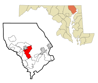
Bel Air South is a census-designated place (CDP) in Harford County, Maryland, United States. The population was 47,709 at the 2010 census, up from 39,711 in 2000.
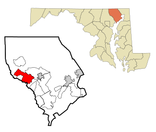
Fallston is a census-designated place (CDP) in Harford County, Maryland, United States. The population was 8,958 at the 2010 census, up from 8,427 in 2000. Fallston is a semi-rural community consisting mostly of farms and suburban-like developments.

Pleasant Hills is a census-designated place (CDP) in Harford County, Maryland, United States. The population was 3,379 at the 2010 census, up from 2,851 in 2000. There is no post office with the designation "Pleasant Hills"; most of the residents have either Fallston or Kingsville addresses and consider themselves as belonging to those communities.

Riverside is a census-designated place (CDP) in Harford County, Maryland, United States. The population was 6,425 at the 2010 census. The term "Riverside" is generally used interchangeably with "Belcamp"; both names are accepted for the U.S. Postal Service's ZIP Code of 21017. However, the original community of Belcamp is located south of U.S. Route 40, outside the Riverside CDP.

Elkridge is an unincorporated community and census-designated place (CDP) in Howard County, Maryland, United States. The population was 15,593 at the 2010 census. Founded early in the 18th century, Elkridge is adjacent to two other counties, Anne Arundel and Baltimore.

Forest Heights is a town in Prince George's County, Maryland, United States, and is part of the larger postal designation of Oxon Hill. The town straddles both sides of dual-lane Maryland Route 210 and includes two elementary schools. Per the 2020 census, the population was 2,658.

Glenarden is a city in Prince George's County, Maryland, United States. Per the 2020 census, the population was 6,402.

Morningside is an incorporated town in Prince George's County, Maryland, United States. Per the 2020 census, the population was 1,240. The town developed with the establishment of nearby Andrews Air Force Base and the federal Census Bureau. The government of the town is led by a mayor and town council. Morningside Elementary School and Benjamin Foulois Junior High School/Elementary/Creative and Performing Arts Academy (current) as well as Michael J Polley Neighborhood Park are located within the town limits. Morningside has one of the largest VFW posts (chapters) in the entire country. Morningside is also the city of license of one of Washington's most prominent radio stations, from the 1960s to the present, WJFK and WPGC-FM. Additionally, Morningside is home to one of the busiest volunteer fire departments in Prince George's County, Morningside VFD Station 827. In 2015, station 827 ran over 8,000 calls for service with 150 working fires in Morningside and the adjacent communities, and has garnered national recognition for their service to the community.
New Carrollton is a city located in central Prince George's County, Maryland, United States. As of the 2020 census, the population was 13,715. New Carrollton is located 10 miles (16 km) east of central Washington, D.C.

Federal Hill is a neighborhood in Baltimore, Maryland, that lies just to the south of the city's central business district. Many of the structures are included in the Federal Hill Historic District, listed on the National Register of Historic Places in 1970. Other structures are included in the Federal Hill South Historic District, listed in 2003.

Washington Hill is a neighborhood in Baltimore, Maryland, United States. It is north of Fells Point, south of Johns Hopkins Hospital, east of Old Town and Jonestown and west of Butchers Hill. It is bounded by Fayette Street, Washington Street, Lombard Street, and Central Avenue. The neighborhood surrounds Broadway running north from Fells Point to terminate at East North Avenue and is named for the now-defunct Washington Medical College later known as the Church Home and Hospital on Broadway where famed writer/poet Edgar Allan Poe was taken to die in 1849 after being found comatose in a downtown Baltimore street. In the median strip of Broadway is a statue of seven-term mayor of Baltimore, Ferdinand Claiborne Latrobe.

Middle East is a neighborhood in the heart of East Baltimore, Maryland.
O'Donnell Heights is a neighborhood named for a public housing development in the far southeastern part of the city of Baltimore, Maryland, United States. It is located south and east of Interstate 95, just west of the border with Baltimore County, and north of the St. Helena neighborhood.

Woodberry is a neighborhood located in the north-central area of Baltimore, Maryland, USA. A largely residential, middle-class area, Woodberry is a historic community bordered on the north by Cold Spring Lane, on the south by Druid Hill Park, on the west by Greenspring Avenue, and on the east by the Jones Falls Expressway and the Jones Falls. Woodberry is located within Postal Zip code 21211.
Lakeland is a neighborhood in south Baltimore, Maryland. Its borders are Annapolis Road on the east, the Baltimore city/county line to the south, a CSX/MARC Railroad line to the west, and the same railroad line to the north.