
Natural Bridge is a geological formation in Rockbridge County, Virginia, comprising a 215-foot-high (66 m) natural arch with a span of 90 feet (27 m). It is situated within a gorge carved from the surrounding mountainous limestone terrain by Cedar Creek, a small tributary of the James River. Consisting of horizontal limestone strata, Natural Bridge is the remains of the roof of a cave or tunnel through which the Cedar Creek once flowed.

The Cacapon River, located in the Appalachian Mountains of West Virginia's Eastern Panhandle region, is an 81.0-mile-long (130.4 km) shallow river known for its fishing, boating, wildlife, hunting, and wilderness scenery. As part of the Potomac River watershed, it is an American Heritage River.

Tunkhannock Creek Viaduct is a concrete deck arch bridge on the Nicholson Cutoff rail segment of the Norfolk Southern Railway Sunbury Line that spans Tunkhannock Creek in Nicholson, Pennsylvania. Measuring 2,375 feet (724 m) long and towering 240 feet (73.15 m) when measured from the creek bed, it was the largest concrete structure in the world when completed in 1915 and still merited "the title of largest concrete bridge in America, if not the world" 50 years later.

The Parkersburg Bridge crosses the Ohio River between Parkersburg, West Virginia, and Belpre, Ohio. Designed by Jacob Linville, the bridge has 46 spans: 25 deck plate girder, 14 deck truss, 6 through truss, and 1 through plate girder. 50,000 cubic yards (38,000 m3) of stone were used for the 53 piers. The bridge was constructed from May 1869 to January 1871 by the Baltimore and Ohio Railroad. At the time of its completion, the bridge was reportedly the longest in the world at 7,140 feet (2,180 m).
The Indian Creek Covered Bridge is a historic covered bridge near US 219, about 4 miles away from Salt Sulphur Springs, in Monroe County, West Virginia, United States. It is owned by the Monroe County Historical Society, and was originally built in 1898 by Ray and Oscar Weikel. The bridge is 49.25 feet long and 11.5 feet wide.

The Baltimore & Ohio Railroad Bridge, Antietam Creek was a timber trestle bridge near Keedysville, Washington County, Maryland, United States. It carried the Washington County branch of the Baltimore and Ohio Railroad, later part of CSX Transportation, over the ravine formed by the Antietam Creek northwest of Keedysville. The wooden bridge, constructed about 1867, was approximately 400 feet (120 m) in length and was supported by a series of timber bents resting on concrete sills. CSX abandoned the railroad line in the late 1970s or 1980s.

Park's Gap Bridge is a historic Howe Truss bridge located near Martinsburg, at Tomahawk, Berkeley County, West Virginia. It was built in 1892, and has a span 93 feet (28 m) long and 12 feet (3.7 m) wide over Back Creek. It is a simple span pony truss supported on stone abutments.

Sarvis Fork Covered Bridge, also known as Sandyville Covered Bridge, is a historic covered bridge located near Sandyville, Jackson County, West Virginia. It was built in 1889-1890 for $64.00 by R.B. Cunningham and G.W. Staats in 1890, originally spanning John Carnahan's Fork, a branch of Mill Creek. When US Route 33 was built using an iron bridge, the covered bridge was first abandoned, then moved and rebuilt over the Left Fork of the Sandy Creek in 1924 for $1,050.00.

Lost Creek station is a historic railroad depot located at Lost Creek, Harrison County, West Virginia. It was built in 1892 by the Baltimore and Ohio Railroad, and is a one-story, Folk Victorian frame building with board-and-batten siding. It measures 44 by 18.5 feet. In 1923, it was the largest cattle shipping point east of the Mississippi River.

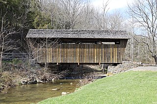
Laurel Creek Covered Bridge is a historic covered bridge located near Lillydale, Monroe County, West Virginia. It was built in 1910. The shortest covered bridge in the state, it measures 34 feet, 6 inches long and 13 feet, 2 1/2 inches wide. It has wood siding painted red and a galvanized metal roof. By 1981, it was one of only 17 covered bridges left in West Virginia.

The Catoctin Creek Bridge crosses over Catoctin Creek in Loudoun County, Virginia.

Valley Railroad Stone Bridge is a historic stone arch bridge spanning Folly Mills Creek near Jolivue, Augusta County, Virginia. It was built in 1874 by the Valley Railroad, and is a four-span structure with an overall length of 130 feet (40 m) and a width of 15 feet (4.6 m). It is constructed of granite and faced in ashlar and features semi-circular arches set on gently splayed piers. It was acquired by the Virginia Department of Transportation in 1965. It is considered a scenic landmark along Interstate 81.

The Bridge at Falling Creek is a historic stone arch bridge located near Richmond, in Chesterfield County, Virginia. It was built about 1823 of rough-cut, uncoursed granite. It is carried by two semicircular barrel arches with voussoirs of rough-finished granite. Its width including parapets is 24 feet (7.3 m), and its llength is 148 feet (45 m). It carried the southbound lanes of U.S. Route 301 until 1977, when it was put out of service. It is accessible from a wayside that includes the Falling Creek UDC Jefferson Davis Highway Marker. The bridge was partially damaged in 2004 but still remains significant. It was listed on the National Register of Historic Places in 1995.

Oak Ridge Railroad Overpass is a historic Pratt truss bridge located near Shipman, Nelson County, Virginia. It was built by the Keystone Bridge Company in 1882, and is a single-span, through Pratt truss with two wooden beam approach spans. The span length is 100 feet (30 m). The approach spans are 19 feet (5.8 m) long. It carries VA State Route 653 over the busy Norfolk Southern Washington District, part of the former Southern Main Line between Washington, D.C. and Atlanta.

Linville Creek Bridge is a historic Thacher truss bridge located near Broadway, Rockingham County, Virginia. It was built by the Wrought Iron Bridge Company in 1898. It is a single span, measuring 135 feet 11 inches (41.43 m) long. This bridge was formerly identified as a hybrid Whipple, incorporating aspects of both the double-intersection Pratt and the double-intersection Warren. The structure in actuality is a Thacher truss, a hybrid configuration incorporating elements of the Pratt, Warren, Fink, and Bollman trusses that was first patented by Edwin Thacher in 1883. Its unusual configuration and the bewildering number of descriptions that have been applied to it merely reinforce its position as a bridge that is a rare survivor of an uncommon form.

Hunting Creek Railroad Bridge is a historic stone railroad bridge located at Morganton, Burke County, North Carolina. It was built about 1860, and is a two-span, stone arch bridge. It measures 130 feet long and stands about 24 feet above the creek. It was replaced by another bridge by at least 1890.
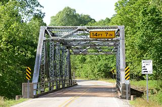
The AR 289 Bridge Over English Creek is a historic bridge in rural eastern Fulton County, Arkansas. The bridge, a single-span steel Pratt through-truss structure, carries Arkansas Highway 289 over English Creek south of Mammoth Spring. The span is 122 feet (37 m) long and 20 feet (6.1 m) wide, and rests on concrete abutments. Built in 1929 by the Virginia Bridge and Iron Company, it is important as a well-preserved example of its type in Fulton County, and for its historical role in transportation in the region.

Avon Five Arch Bridge is a historic railroad arch bridge located at Avon in Livingston County, New York. It was built in 1856–1857 by the Rochester-Avon-Geneseo-Mount Morris Railroad. The bridge measures 200 feet long, 12 feet wide, and approximately 30 feet high. It consists of five elliptical arches built of ashlar on limestone piers. The rail line was abandoned in 1941, and the bridge stabilized in 1992. It is located in a public park.
The Chicago, Rock Island and Pacific Railroad Stone Arch Viaduct, also known as the Old Stone Arch, is located northeast of Shelby, Iowa, United States. The span carried the Chicago, Rock Island and Pacific Railroad tracks over Little Silver Creek. It measures 35 feet (11 m) from the water level to the deck, 20 feet (6.1 m) in width, and 30 feet (9.1 m) in length. The bridge has flanking wingwalls that measure 40 feet (12 m) in length. Limestone for the bridge was quarried near Earlham, Iowa and transported by train to the site. It is one of two such bridges known to exist in Shelby County. The Rock Island was the first railroad to enter the county, and continued to operate here into the 1950s. At that time they abandoned the line when the Atlantic cutoff was built providing a more direct route between Atlantic, Iowa and Council Bluffs. While the tracks were removed, the stone arch, the railroad grade, and the right-of-way were left intact. They are now part of the Rock Island Old Stone Arch Nature Trail. The bridge was listed on the National Register of Historic Places in 1998.

The Conant Creek Pegram Truss Railroad Bridge, in Fremont County, Idaho near Grainville, Idaho and Ashton, Idaho, was built in 1894. It brought a railroad over the Conant Creek, 1 mile south of the junction of Squirrel Rd. and the old Ashton-Victor railroad spur tracks. It is a Pegram truss bridge, designed by George H. Pegram. It was listed on the National Register of Historic Places in 1997.


