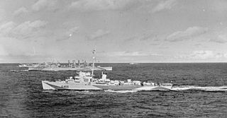
HMS Bickerton was a Captain-class frigate of the Buckley type during World War II. Named after Sir Richard Bickerton commander of HMS Terrible at the First Battle of Ushant during the American Revolutionary War.
Gurgulyat is a village in Slivnitsa Municipality, Sofia Province, located in western Bulgaria approximately 10 km south of the town of Slivnitsa.

Kalotina is a village in Dragoman Municipality, Sofia Province, in westernmost central Bulgaria. As of 2010 it has 270 inhabitants and the mayor is Lidia Bozhilova. The village is located at the border with Serbia, 55 km to the northwest of the capital Sofia, on the main highway and railway between Western Europe and Asia. Kalotina lies at 42°59′N22°52′E, 282 metres above sea level. Kalotina is known for the Kalotina-Gradinje border checkpoint, one of Bulgaria's busiest and best-known due to the proximity to Sofia. The Nishava River, a tributary of the South Morava, flows nearby.

Surmacze is a village in the administrative district of Gmina Biała Podlaska, within Biała Podlaska County, Lublin Voivodeship, in eastern Poland. It lies approximately 10 kilometres (6 mi) west of Biała Podlaska and 90 km (56 mi) north of the regional capital Lublin.
Wartkowice is a village in Poddębice County, Łódź Voivodeship, in central Poland. It is the seat of the gmina called Gmina Wartkowice. It lies approximately 10 kilometres (6 mi) north of Poddębice and 39 km (24 mi) north-west of the regional capital Łódź.
Chruślanki Józefowskie is a village in the administrative district of Gmina Józefów nad Wisłą, within Opole Lubelskie County, Lublin Voivodeship, in eastern Poland. It lies approximately 19 kilometres (12 mi) south of Opole Lubelskie and 49 km (30 mi) south-west of the regional capital Lublin.
Krupia Wólka is a village in the administrative district of Gmina Prażmów, within Piaseczno County, Masovian Voivodeship, in east-central Poland. It lies approximately 7 kilometres (4 mi) north-east of Prażmów, 10 km (6 mi) south of Piaseczno, and 26 km (16 mi) south of Warsaw.
Przesieki is a village in the administrative district of Gmina Krzyż Wielkopolski, within Czarnków-Trzcianka County, Greater Poland Voivodeship, in west-central Poland. It lies approximately 16 kilometres (10 mi) north of Krzyż Wielkopolski, 42 km (26 mi) west of Czarnków, and 93 km (58 mi) north-west of the regional capital Poznań.
Sucholaski is a village in the administrative district of Gmina Wydminy, within Giżycko County, Warmian-Masurian Voivodeship, in northern Poland. It lies approximately 5 kilometres (3 mi) north-west of Wydminy, 15 km (9 mi) east of Giżycko, and 101 km (63 mi) east of the regional capital Olsztyn.
Klášterní Skalice is a village and municipality in Kolín District in the Central Bohemian Region of the Czech Republic.

Boljare is a village in the municipality of Vlasotince, Serbia. According to the 2002 census, the village has a population of 983 people.
Donja Lomnica is a village in the municipality of Vlasotince, Serbia. According to the 2002 census, the village has a population of 591 people.
Bogomil is a village in the municipality of Harmanli, in Haskovo Province, in southern Bulgaria.
Korbevac is a village in the municipality of Vranje, in southern Serbia. According to the 2002 census, the village has a population of 711 people.
Lepčince is a village in the municipality of Vranje, Serbia. According to the 2002 census, the village had a population of 125 people.
Srednji Del is a village in the municipality of Vranje, Serbia. According to the 2002 census, the village has a population of 90 people.
Gökmenler is a village in the Saimbeyli, Adana Province, Turkey.
Zoungoudo is an arrondissement in the Zou department of Benin. It is an administrative division under the jurisdiction of the commune of Agbangnizoun. According to the population census conducted by the Institut National de la Statistique Benin on February 15, 2002, the arrondissement had a total population of 2,135.

Drmeni is a village in the Resen Municipality of the Republic of North Macedonia, north of Lake Prespa. It has 416 residents as of the 2002 census.
Ababkovo is the name of several rural localities in Russia:


