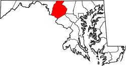
Ballenger Creek, Maryland

Last updated

Ballenger Creek, Maryland
Frederick County Maryland Incorporated and Unincorporated areas Ballenger Creek Highlighted.svg
Location of Ballenger Creek, Maryland
Coordinates: 39°22′54″N77°24′58″W / 39.38167°N 77.41611°W / 39.38167; -77.41611
CountryFlag of the United States.svg  United States
State Flag of Maryland.svg  Maryland
County Flag of Frederick County, Maryland.svg Frederick
Area
[1]
  Total10.81 sq mi (28.00 km2)
  Land10.80 sq mi (27.96 km2)
  Water0.01 sq mi (0.04 km2)
Elevation
[2]
295 ft (90 m)
Population
 (2020)
  Total24,999
  Density2,315.58/sq mi (894.04/km2)
Time zone UTC−5 (Eastern (EST))
  Summer (DST) UTC−4 (EDT)
Area codes 301, 240
FIPS code 24-03800
GNIS feature ID2389170 [2]

Ballenger Creek is an unincorporated community and census-designated place (CDP) in Frederick County, Maryland, United States. It is a part of the Frederick, Maryland urban area and is adjacent to Frederick's southern city limits. The CDP had a 2010 census population of 18,274. [3]

Contents

Geography

Ballenger Creek is located in south-central Frederick County at 39°22′54″N77°25′58″W / 39.38167°N 77.43278°W / 39.38167; -77.43278 (39.381593, −77.432802). [4] The namesake stream flows west to east through the community towards the Monocacy River, part of the Potomac River watershed.

According to the United States Census Bureau, the CDP has a total area of 10.8 square miles (28.1 km2), of which 0.02 square miles (0.04 km2), or 0.14%, is water. [3]

Demographics

Historical population
CensusPop.Note
1990 5,546
2000 13,518143.7%
2010 18,27435.2%
2020 24,99936.8%
source: [5] [6]

As of the census [7] of 2010, 18,274 people, 6,932 households, and 4,558 families reside in the CDP. The population density was 1,692.0 inhabitants per square mile (653.3/km2). There were 7,372 housing units at an average density of 682.0 per square mile (263.3/km2). The racial makeup of the CDP was 69.7% White, 15.6% African American, 0.4% Native American, 6.6% Asian, 0.1% Pacific Islander, 3.2% from other races, and 4.3% from two or more races. Hispanic or Latino of any race were 10.1% of the population.

There were 4,542 households, which 24.9% had children under 18 living with them, 47.4% were married couples living together, 12.6% had a female householder with no husband present, and 35.7% were non-families. 28.5% of all households were made up of individuals, and 9.5% had someone living alone who was 65 years of age or older. The average household size was 2.57 and the average family size was 3.22.

In the CDP, the population was spread out, with 26.7% under 18, 8.5% from 18 to 24, 34.3% from 25 to 44, 22.4% from 45 to 64, and 8.1% who were 65 years of age or older. The median age was 33.5 years. For every 100 females, there were 96.9 males. For every 100 females age 18 and over, there were 94.9 males.

The median income for a household in the CDP was $56,558, and the median income for a family was $65,216. Males had a median income of $42,350 versus $31,233 for females. The per capita income for the CDP was $24,816. About 3.2% of families and 3.6% of the population were below the poverty line, including 3.9% of those under age 18 and 5.8% of those age 65 or over.

Business community

Ballenger Creek's establishment as an urban community and continued development has been strongly tied to the presence of numerous corporate and technology companies located within the I-270 Technology Corridor. Ballenger Creek is the site of many of the corporate parks that contribute substantially to the Frederick area economy, including Frederick Research Park, Stanford Industrial Park, Westview South, Westview Village, Wedgewood Business Park, McKinney Industrial Park, Westview Corporate Campus, Ballenger Center, Frederick Corporate Park and 270 Technology Park. [8]

Schools

Related Research Articles

<span class="mw-page-title-main">Tanaina, Alaska</span> CDP in Alaska, United States

Tanaina is a census-designated place (CDP) in the Matanuska-Susitna Borough in the U.S. state of Alaska. Located 4 miles north from Wasilla, it is part of the Anchorage, Alaska Metropolitan Statistical Area. At the 2020 census the population was 8,817, up from 8,197 in 2010. Tanaina is the sixth-most populated CDP in Alaska.

<span class="mw-page-title-main">Game Creek, Alaska</span> Census-designated place in Alaska, United States

Game Creek is a census-designated place (CDP) on Chichagof Island in Hoonah-Angoon Census Area, Alaska, United States. The population was 18 at the 2010 census, down from 35 at the 2000 census.

<span class="mw-page-title-main">Westview, Florida</span> Census-designated place in Florida

Westview is a census-designated place (CDP) in Miami-Dade County, Florida, United States. It is part of the Miami metropolitan area of South Florida. The population was 9,923 at the 2020 census.

<span class="mw-page-title-main">Deale, Maryland</span> Census-designated place in Maryland, United States

Deale is a census-designated place (CDP) in Anne Arundel County, Maryland, United States. The population was 4,945 at the 2010 census. It has a scenic view of Chesapeake Bay and is popular with boaters. Sudley was listed on the National Register of Historic Places in 1973.

<span class="mw-page-title-main">Catonsville, Maryland</span> Census-designated place in Maryland, United States

Catonsville is a census-designated place (CDP) in Baltimore County, Maryland. The population was 44,701 at the 2020 US Census. The community is a streetcar suburb of Baltimore along the city's western border. The town is known for its proximity to the Patapsco River and Patapsco Valley State Park, making it a regional mountain biking hub. The town is also notable as a local hotbed of music, earning it the official nickname of "Music City, Maryland." Catonsville contains the majority of the University of Maryland, Baltimore County (UMBC), a major public research university with close to 14,000 students.

<span class="mw-page-title-main">Clover Hill, Maryland</span> Unincorporated community in Maryland

Clover Hill is an unincorporated community and former census-designated place (CDP) in Frederick County, Maryland, United States. The population was 3,260 at the 2000 census. The area was not listed as a CDP for the 2010 census, and no population total was published.

<span class="mw-page-title-main">Green Valley, Maryland</span> Census-designated place in Frederick County, Maryland, United States

Green Valley is an unincorporated area and census-designated place (CDP) in southern Frederick County, Maryland, United States. The population was 12,643 at the 2020 census. The area was listed as a census-designated place in 2000 but not listed as part of any CDP at the 2010 census. It was re-designated a census-designated place for the 2020 census.

<span class="mw-page-title-main">Marlton, Maryland</span> Census-designated place in Maryland

Marlton is an unincorporated area and census-designated place (CDP) in Prince George's County, Maryland, United States. The population was 9,802 at the 2020 census. The Marlton housing development, at first briefly called "Brandywine Country", grew up along U.S. Route 301 in the 1970s, and is part of the greater Upper Marlboro community. Originally made up of only single-family homes, more recently townhouses have been added.

<span class="mw-page-title-main">Cordova, Maryland</span> Census-designated place in Maryland, United States

Cordova is a census-designated place (CDP) in Talbot County, Maryland, United States. The population was 551 at the 2020 census, down from 592 at the 2000 census.

<span class="mw-page-title-main">San Mar, Maryland</span> CDP in Maryland, United States

San Mar is a census-designated place (CDP) in Washington County, Maryland, United States. The population was 515 at the 2000 census.

Jasper is a town located in Steuben County, New York, United States. As of the 2020 census, the town had a total population of 1,418. The name is that of a military hero at Fort Moultrie, William Jasper.

Tuscarora township is a township in Steuben County, New York, United States. The population was 1,388 at the 2020 census. The township is named after the Tuscarora tribe.

<span class="mw-page-title-main">Beale Township, Pennsylvania</span> Township in Pennsylvania, United States

Beale Township is a township in Juniata County, Pennsylvania, United States. The population was 769 at the 2020 census, a decline from the figure of 830 tabulated in 2010.

East Waterford is a census-designated place (CDP) in Tuscarora and Lack townships in Juniata County, Pennsylvania, United States. The population was 196 at the 2010 census.

<span class="mw-page-title-main">Fort Hunt, Virginia</span> Census-designated place in Virginia, United States

Fort Hunt is a census-designated place (CDP) in Fairfax County, Virginia, United States. The area is named after Fort Hunt, which was built on the bank of the Potomac River in 1897 to defend Washington, D.C. from naval attack and is now a public park. The area is also notable for its high population of senior citizens and for being one of the first suburbs in wealthy Fairfax County. The population was 17,231 at the 2020 census.

<span class="mw-page-title-main">Idylwood, Virginia</span> Census-designated place in Virginia, United States

Idylwood is a census-designated place (CDP) in Fairfax County, Virginia, United States. The population was 17,954 as of the 2020 census. It originally developed as a suburban community along the route of the Washington and Old Dominion Railroad, and later along Virginia State Route 7. The construction of the Capital Beltway in the 1960s, and I-66 and the Orange Line of the Washington Metrorail system in the 1980s, as well as the concurrent development of nearby Tysons Corner into Washington's leading suburban business district, led to the development of several apartment, townhouse, and small-lot single-family housing complexes, as well as the high-rise Idylwood Towers condominium, in the portion of Idylwood lying to the north of I-66. The area to the south of I-66 remains primarily large-lot single-family.

<span class="mw-page-title-main">West Springfield, Virginia</span> Census-designated place in Virginia, United States

West Springfield is a census-designated place (CDP) in Fairfax County, Virginia, United States. The population was 23,369 at the 2020 census.

Red Butte is a census-designated place (CDP) in Natrona County, Wyoming, United States. It is part of the Casper, Wyoming Metropolitan Statistical Area. The population was 1,430 at the 2020 census.

<span class="mw-page-title-main">Chevy Chase (CDP), Maryland</span> Census-designated place in Maryland, United States

Chevy Chase is a census-designated place (CDP) in Montgomery County, Maryland, United States. The population was 10,176 at the 2020 census.

<span class="mw-page-title-main">Adamstown, Maryland</span> Census-designated place in Maryland

Adamstown is an unincorporated community and census-designated place (CDP) in Frederick County, Maryland, United States. It is named for Adam Kohlenberg, a station agent and first town merchant who owned much of present-day Adamstown. As of the 2010 census, the Adamstown CDP had a population of 2,372.

References

  1. "2020 U.S. Gazetteer Files". United States Census Bureau. Retrieved April 26, 2022.
  2. 1 2 U.S. Geological Survey Geographic Names Information System: Ballenger Creek, Maryland
  3. 1 2 "Geographic Identifiers: 2010 Census Summary File 1 (G001), Ballenger Creek CDP, Maryland". American FactFinder. U.S. Census Bureau. Archived from the original on February 13, 2020. Retrieved May 31, 2016.
  4. "US Gazetteer files: 2010, 2000, and 1990". United States Census Bureau. February 12, 2011. Retrieved April 23, 2011.
  5. "CENSUS OF POPULATION AND HOUSING (1790–2000)". U.S. Census Bureau . Retrieved July 17, 2010.
  6. "2010 Demographic Profile Data". U.S. Census Bureau. Archived from the original on February 12, 2020. Retrieved August 24, 2011.
  7. "U.S. Census website". United States Census Bureau . Retrieved January 31, 2008.
  8. ""Mission: Frederick County" Attracts Regional Brokers". Frederic County Office of Economic Development. May 20, 2008. Archived from the original on April 2, 2012. Retrieved September 6, 2011.