Related Research Articles
Belgaum (IAST:Bēḷagāma) is a city in the Indian state of Karnataka located in its northern part along the Western Ghats. It is the administrative headquarters of the eponymous Belgaum division and Belgaum district. The Government of Karnataka has proposed making Belgaum the second capital of Karnataka, hence a second state administrative building Suvarna Vidhana Soudha was inaugurated on 11 October 2012.

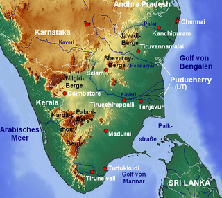
Palar is a river of southern India. It rises in the Nandi Hills in Chikkaballapura district of Karnataka state, and flows 93 kilometres (58 mi) in Karnataka, 33 kilometres (21 mi) in Andhra Pradesh and 222 kilometres (138 mi) in Tamil Nadu before reaching its confluence into the Bay of Bengal at Vayalur about 100 kilometres (62 mi) south of Chennai. It flows as an underground river for a long distance only to emerge near Bethamangala town, from where, gathering water and speed, it flows eastward down the Deccan Plateau. The Towns of Bethamangala, Santhipuram, Kuppam, Ramanaickenpet, Vaniyambadi, Ambur, Melpatti, Gudiyatham, Pallikonda, Melmonavoor, Vellore, Katpadi, Melvisharam, Arcot, Ranipet, Walajapet, Kanchipuram, Walajabad, Chengalpattu, Kalpakkam, and Lattur are located on the banks of the Palar River. Of the seven tributaries, the chief tributary is the Cheyyar River.

The Tungabhadra River is a river in India that starts and flows through the state of Karnataka during most of its course, before flowing along the border between Telangana, Andhra Pradesh and ultimately joining the Krishna River near Sangameswaram village in Kurnool district of Andhra Pradesh. In the epic Ramayana, the Tungabhadra River was known by the name of Pampa.

Gokak is a taluka headquarters in the Belgaum District of Karnataka state, India. It is located around 70 km from Belgaum at the confluence of two rivers, the Ghataprabha and the Markandeya. The population of the town is according to 2011 census is approximately 135,773. The common language in use is Kannada.
Godachinmalki Falls in Godachinamalaki village is a waterfall located on Markandeya river in Belgaum district, Gokak Taluk, Karnataka, India. It is 15 kilometers away from Gokak and 40 kilometers from Belgaum. It is located in a deep green valley.

North Karnataka is a geographical region consisting of mostly semi-arid plateau from 300 to 730 metres elevation that constitutes the northern part of the Karnataka state in India. It is drained by the Krishna River and its tributaries the Bhima, Ghataprabha, Malaprabha, and Tungabhadra. North Karnataka lies within the Deccan thorn scrub forests ecoregion, which extends north into eastern Maharashtra.

Hukkeri is a Town Municipal Council and taluka in Belagavi district in the Indian state of Karnataka. Archeological studies reveal that the name Hukkeri is supposed to have been derived from the word Huvinakeri which means Street of Flowers. During Adil Shahi times, roses of good quality were grown here and were sent to Bijapur.
Siruguppa is a City and Taluka in Bellary district in Karnataka. The region is .known as "The land of paddy", this City is one of the major rice exporters of the state.
The Malaprabha River is a tributary of the Krishna River and flows through the state of Karnataka in India. It rises in the Western Ghats at an altitude of 792.4 m (2,600 ft) in the state's Belgaum district. The river joins Krishna River at Kudalasangama in Bagalkot district.
Ghataprabha is a village in the southern state of Karnataka, India. It is located in the Gokak taluk of Belgaum district in Karnataka.
Ballari is a major district in Karnataka state, India. It is located at north-eastern part of Karnataka. This district belongs to Kalyana-Karnataka. This district is one of the biggest districts in Karnataka.
Athani is a city next to Gokak in the Belgaum district of Karnataka, India. It is 140 kilometers from the city of Belagavi, 70 kilometers from Vijayapura, 55 kilometers from Miraj, 100 kilometers from Kolhapur, 200 kilometers from Hubballi, and 624 kilometers from Bengaluru. The main profession here is agriculture, particularly sugarcane, jawar, and grapes. The river Krishna flows 110 km around the southern part of Athani Taluk. the city 18 km from river Krishna It is the largest sugar production Taluk in Karnataka. It is famous for leather chappals. Athani is the oldest municipal town of Karnataka; it was established in 1853 according to the municipal act of 1850,The municipal council completed 160 years.
Shedbal is a town in the southern state of Karnataka, India. It is located in the Athni taluk of Belagavi district in Karnataka. Shedbal is very close to Sangli Miraj twin cities.
Shiraguppi is a village in the southern state of Karnataka, India. It is located in the Athni taluk of Belgaum district in Karnataka.
Markandeya or Markanda is a river in the Indian states of Karnataka and Tamil Nadu. It flows into the South Pennar River near Krishnagiri Dam in Krishnagiri district of Tamil Nadu.

The Tungabhadra Dam also known as Pampa Sagar is constructed across the Tungabhadra River, a tributary of the Krishna River. The dam is in Hosapete, Ballari district of Karnataka. It is a multipurpose dam serving irrigation, electricity generation, flood control, etc. This is a joint project of erstwhile Hyderabad state and erstwhile Madras Presidency when the construction was started; later it became a joint project of Karnataka and Andhra Pradesh after its completion in 1953. The main architect of the dam was Vepa Krishnamurthy, ISE, Engineer-in-Chief, Hyderabad State, after Police Action, an engineer from Madras PWD. There is a dispute between Andhra Pradesh,Telangana and Karnataka for the water of Tungabhadra reservoir. He argued for the stability and longevity of the Dam, built of Surki Mortar viz a combination of mud and limestone. It's the only non-cement and concrete dam in the country and has withstood the test of time for over 70 years, and may well cross many more decades. He envisioned it as being built with a large contingent of manual labour, as best suited to Indian labouravailabilty and employment. The main contractor for the dam was Venkat Reddy Mulamalla, from Konour village, Mahabubnagar, Hyderabad state.

Raja Lakhamagouda dam, also known as Hidkal dam, is a dam constructed across the Ghataprabha River in the Krishna River basin. It is situated at Hidkal village in Hukkeri Taluk of Belagavi district in North Karnataka, India. The dam with the height of 62.48 metres and 10 Vertical Crest Gates, impounds a large reservoir with a gross surface area of 63.38 Square kilometres, and storage capacity of 51.16 Tmcft. It is an earthen and masonry dam which caters to the Irrigation needs for over 8,20,000 acres, and Hydel power generation. It is constructed as a part of the Ghataprabha Irrigation project which was completed in three phases and finished in 2009. The dam is named after Raja Lakhamagouda Sardesai, philanthropist and Zamindar of Vantamuri.
Chulki Nala is a river in Bidar District. It starts at Chowkiwadi in Basavakalyan taluka. It flows for 42 km in Bidar district and joins the river Karanja. A Composite Dam is built near Mustapur village of Basava Kalyana Taluk in Bidar District for Irrigation and Drinking water purposes. The dam has a storage capacity of 0.93 tmcft of water. The catchment area is 243.55 km2. It provides drinking water to Basavakalyan town.
Markandeya is a river of southern India. It rises in the Bailur in Khanapur Taluk of Belgaum district, Karnataka state, enters Belagavi taluk on southern side and flows towards western side of the Belagavi city and flows 66 kilometres (41 mi) in Belgaum district forming beautiful Godchinamalaki Falls before reaching its confluence into the Ghataprabha River at Gokak about 60 kilometres (37 mi) from Belgaum
Belagavi Nala is a river of southern India. It rises at Laxmi Tekdi in Belgaum city of Karnataka state, flows towards South-eastern side of the Belagavi city and flows through Camp, Station Road, Shastry Nagar, Shivaji Garden and Vishwakarmanagar right up to Old PB Road, before reaching its confluence into the Bellary Nala at Laxminagar in Belgaum.
References
- ↑ http://www.theijes.com/papers/v3-i6/Version-5/E0365037045.pdf Bellary Nala
- ↑ Bellary Nala flooding will be disastrous
- ↑ Bellary Nala turning into a curse for farmers
- ↑ Bellary Nala spills over, 700 acres under water https://www.news18.com/news/india/bellary-nala-spills-over-700-acres-under-water-390462.html
- ↑ https://vijaykarnataka.com/news/belagavi/bellary-nala/articleshow/53230613.cms ಬಳ್ಳಾರಿ ನಾಲಾ ಹೂಳೆತ್ತಲು ಕ್ರಮ
- ↑ Belagavi villagers demand filter plant to treat contaminated water from Ballari Nala https://www.thehindu.com/news/national/karnataka/Belagavi-villagers-demand-filter-plant-to-treat-contaminated-water-from-Ballari-Nala/article16076721.ece
- ↑ https://www.researchgate.net/publication/260740048_WATER_QUALITY_ASSESSMENT_OF_BELLARY_NALA_BELGAUM WATER QUALITY ASSESSMENT OF BELLARY NALA, BELGAUM
- ↑ https://www.projectsmonitor.com/daily-wire/balance-works-of-bellary-nala-irrigation-project/ bellary-nala-irrigation-project
- ↑ http://knnlindia.com/pdf/Annual%20Report%202017%20English%20with%20Photos.pdf BELLARY NALA PROJECT
- ↑ https://allaboutbelgaum.com/news/belagavi-nala-revitalisation-project-wins-isola-award/ Belagavi Nala Revitalisation project wins ISOLA award