Related Research Articles

Goodyear is a city in Maricopa County, Arizona, United States. It is a suburb of Phoenix and at the 2020 census had a population of 95,294, up from 65,275 in 2010 and 18,911 in 2000. It was the third-fastest-growing city in Arizona between 1990 and 2000.

Litchfield Park is a city in Maricopa County, Arizona, United States. It is located 19 miles (31 km) west of Phoenix. As of the 2020 census, the population of the city was 6,847, up from 5,476 in 2010.

New River is an unincorporated community and census-designated place (CDP) in Maricopa County, Arizona, United States. The population was 17,290 as of the 2020 census, up from 14,952 at the 2010 census.

Arizona City is a census-designated place (CDP) in southwestern Pinal County, Arizona, United States. It is located near the junction of Interstate 8 and Interstate 10 at the midpoint between Phoenix and Tucson, approximately 60 miles (97 km) from the downtown of both cities. The population was 10,475 as of the 2010 U.S. Census. It is estimated to be approximately 11,030 as of a 2017 U.S. Census estimate. Arizona City is a rural, primarily residential community that features a 48-acre man-made lake. These attributes make the community a popular snowbird destination, with the population increasing by as much as 5,000 people in the winter months to reach the census figure of 11,030.
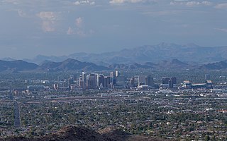
The Phoenix Metropolitan Area – also the Valley of the Sun, the Salt River Valley, or Metro Phoenix – is the largest metropolitan statistical area in the Southwestern United States, centered on the city of Phoenix, that includes much of the central part of Arizona. The United States Office of Management and Budget designates the area as the Phoenix-Mesa-Chandler Metropolitan Statistical Area (MSA), defining it as Maricopa and Pinal counties. It anchors the Arizona Sun Corridor megaregion along with the second most populous metropolitan area in the state, the Tucson metropolitan area. The gross domestic product of the Phoenix Metropolitan Area was $255 billion in 2018, 16th largest amongst metro areas in the United States.

Tonopah is an unincorporated community and census-designated place (CDP) in western Maricopa County, Arizona, United States, 52 miles (84 km) west of downtown Phoenix off Interstate 10. The community is near the Palo Verde Nuclear Generating Station, the largest power producer in the country, nuclear or otherwise. As of the 2020 census, the population of Tonopah was 23, down from 60 at the 2010 census.

Ahwatukee Foothills is an urban village of Phoenix, Arizona. Ahwatukee forms the southernmost portion of Phoenix, and is considered part of the East Valley region of the Phoenix metropolitan area.

Interstate 11 (I-11) is an Interstate Highway that currently runs for 22.8 miles (36.7 km) on a predominantly northwest–southeast alignment in the US state of Nevada, running concurrently with US Route 93 (US 93) between the Arizona state line and Henderson. The freeway is tentatively planned to run from Nogales, Arizona, to the vicinity of Reno, Nevada, generally following the current routes of I-19, I-10, US 93, and US 95. Planners anticipate upgrading two existing highway segments to carry future I-11: US 93 in Arizona from Wickenburg to the Nevada state line on the Mike O'Callaghan–Pat Tillman Memorial Bridge over the Colorado River, and US 95 in Nevada from the Las Vegas Valley to Tonopah. An exact alignment for I-11 has yet to be determined outside of these sections; however, a number of corridor alternatives have been identified for further study and refinement.

The Palo Verde Generating Station is a nuclear power plant located near Tonopah, Arizona, in western Arizona. It is located about 45 miles (72 km) west of downtown Phoenix. Palo Verde generates the largest amount of electricity in the United States per year, and it is the second largest electrical generating facility in terms of capacity. It is a critical asset to the Southwest, generating approximately 32 million megawatt-hours annually.

Mesa del Sol is an uncompleted 16,000-acre (65 km2) mixed-use master planned community in Albuquerque, New Mexico. Mesa del Sol, a 12,900-acre mixed-use community, is located on Albuquerque's South Mesa. By combining job creation with sustainable urban community planning, Mesa del Sol will represent a blend of natural resources, economic objectives, and social amenities in a community with a forward-looking and distinct sense of place. Mesa del Sol is a sustainable city with plans to build 37,000 homes on 4,400 acres of residential property and 18 million square feet of office, industrial, and retail space.

Phoenix–Mesa Gateway Airport, formerly Williams Gateway Airport (1994–2008) and Williams Air Force Base (1948–1993), is an international airport in the southeastern area of Mesa, Arizona, 20 miles southeast of Phoenix, in Maricopa County. The airport, owned and operated by the Phoenix–Mesa Gateway Airport Authority, is a reliever airport for Phoenix Sky Harbor International Airport. It is a base for Allegiant Air.
Stellantis North America, more commonly known as Chrysler, operates proving grounds around North America for development and validation testing of new vehicles.

Arizona is a state in the Southwestern United States. It is the 6th-largest and the 14th-most-populous of the 50 states. Its capital and largest city is Phoenix. Arizona is part of the Four Corners region with Utah to the north, Colorado to the northeast, and New Mexico to the east; its other neighboring states are Nevada to the northwest, California to the west and the Mexican states of Sonora and Baja California to the south and southwest.

The Hummingbird Springs Wilderness is a 31,200-acre (12,626 ha) wilderness administered by the Bureau of Land Management (BLM). The wilderness is located in the northwest of Maricopa County in northern regions of the central Sonoran Desert of Arizona.
Valencia is an unincorporated community in northwestern Los Angeles County, California. This area, with major commercial and industrial parks, straddles State Route 126 and the Santa Clara River.
The Belmont Mountains are a 25 mi (40 km) long, arid, low elevation mountain range about 50 mi west of Phoenix, Arizona in the northern Sonoran Desert, north of the Gila River. The range is in the south of a region of two parallel washes; the Bouse Wash flows northwest to the Colorado River, and the Centennial Wash flows southeast to meet the Gila River.
The Tonopah Desert is a small desert plains region of the Sonoran Desert, located west of Phoenix, Arizona. It is adjacent north of Interstate 10 and lies at the southwest intersection of the Hassayampa River with the Gila River. The Tonopah Desert is also just north of the Gila Bend Mountains massif which create the Gila Bend of the river.

Deer Valley or Deer Valley Village is one of the 15 urban villages that make up Phoenix, Arizona, United States. As of 2010, the population was 165,656, 25% of whom were under 18 years of age. The origin of the name is unclear; it first appeared on a 1921 General Land Office map of the area describing the valley created by Skunk Creek.

The policies protecting land used in Big Sur are some of the most restrictive local-use standards in California, and are widely regarded as one of the most restrictive development protections anywhere. The program protects viewsheds from the highway and many vantage points, and severely restricts the density of development. About 60% of the coastal region is owned by governmental or private agencies which do not allow any development. The majority of the interior region is part of the Los Padres National Forest, Ventana Wilderness, Silver Peak Wilderness or Fort Hunter Liggett. The area is protected by the Big Sur Local Coastal Plan, which preserves it as "open space, a small residential community, and agricultural ranching." Its intention is "preserving the environment and visual access to it, the policies of the local coastal plan are to minimize, or limit, all destination activities."

The Tiger Fire was a wildfire that burned 16,278 acres (6,587 ha) in the U.S. state of Arizona from June to July 2021. The fire was caused by a dry lightning strike in the Prescott National Forest. Although Horsethief Basin Lake was evacuated and both the community of Crown King and the census-designated place of Black Canyon City were threatened, no injuries or deaths were reported, and no buildings were destroyed. Over 300 fire personnel were assigned to contain the blaze.
References
- 1 2 Weiner, Sophie (November 12, 2017). "Bill Gates is Buying Land in Arizona to Build a "Smart City"". Popular Mechanics . Retrieved November 12, 2017.
- 1 2 3 4 5 Reagor, Catherine (November 8, 2017). "Bill Gates invests $80 million in real estate on Phoenix area's western edge". Arizona Republic . Retrieved November 12, 2017.
- 1 2 Grabar, Henry (November 14, 2017). "Bill Gates' Smart City in Arizona Is Not Smart, Not a City, and Has Little to Do With Bill Gates". Slate . Retrieved November 15, 2017.
- ↑ Buono, Bianca (November 10, 2017). "Bill Gates buys big chunk of land in Arizona to build 'smart city'". KPNX 12 News. Archived from the original on November 12, 2017. Retrieved November 12, 2017.
- ↑ Talton, Jon (November 9, 2017). "Bill Gates buys Arizona land — hilarity, or tragedy, ensues". The Seattle Times . Retrieved November 12, 2017.
Municipalities and communities of Maricopa County, Arizona, United States | ||
|---|---|---|
| Cities |  | |
| Towns | ||
| CDPs | ||
| Populated places |
| |
| Indian reservations | ||
| Ghost towns/ former populated places | ||
| Footnotes | ‡This populated place also has portions in an adjacent county or counties | |
Coordinates: 33°29′37″N112°46′54″W / 33.49361°N 112.78167°W