Brooklyn–Queens Connector

Last updated

Brooklyn–Queens Connector
Brooklyn Queens Connector depiction.jpg
Depiction of the Brooklyn–Queens Connector at Jay and Willoughby Streets
Overview
Termini
Stations26
Website Official website OOjs UI icon edit-ltr-progressive.svg
Service
Services1 (projected)
Technical
Line length11 mi (18 km)
Number of tracks2
Character Streetcar
Track gauge 1,435 mm (4 ft 8+12 in) standard gauge
Electrification Hydrogen fuel cell
Route map

Contents

BSicon uexKHSTACCa.svg
21 St & 27 Av
BSicon uexHSTACC.svg
21 St & Broadway
BSicon uexHSTACC.svg
21 St & 35 Av
BSicon tCONTgq.svg
BSicon tACCq.svg
BSicon uexSTR.svg
BSicon tCONTfq.svg
21 St & 41 Av
BSicon BLc2.svg
BSicon uexHSTACC.svg
BSicon KBL3.svg
44 Dr
BSicon tCONTgq.svg
BSicon tHSTq.svg
BSicon KBL1.svg
BSicon tSTRq.svg
BSicon uexSTR.svg
BSicon BLc4.svg
BSicon tCONTfq.svg
50 Av & Vernon Blvd
BSicon uexhKRZWae+GRZq.svg
BSicon uexHSTACC.svg
Manhattan Av & Ash St
BSicon uexHSTACC.svg
Greenpoint Av
BSicon uexHSTACC.svg
Berry St & North 13th St
BSicon uexHSTACC.svg
Berry St & North 7th St
BSicon uexHSTACC.svg
Berry St & South 2nd St
BSicon uexHSTACC.svg
Berry St & Broadway
BSicon uexSTR+l.svg
BSicon uexABZgr.svg
BSicon uexBHF(R)f.svg
BSicon uexBHF(L)g.svg
Kent/Wythe Avs & Division Av
BSicon uexSTRl.svg
BSicon uexABZg+r.svg
BSicon uexHSTACC.svg
Washington Av & Kent Av
BSicon uexHSTACC.svg
Brooklyn Navy Yard
BSicon uexHSTACC.svg
Navy St & Flushing Av
BSicon uexHSTACC.svg
Willoughby St & Fleet Pl
BSicon tCONTg.svg
BSicon uexSTR.svg
BSicon tSTR.svg
BSicon BLc2.svg
BSicon uexHSTACC.svg
BSicon KBL3.svg
Willoughby St & Lawrence St
BSicon tCONTgq.svg
BSicon tSTRq.svg
BSicon tACC.svg
BSicon KBL1.svg
BSicon uxmKRZt.svg
BSicon BLc4.svg
BSicon tSTRq.svg
BSicon tLSTR+r.svg
Fulton St & Culver lines NYCS-bull-trans-A-Std.svg NYCS-bull-trans-C-Std.svg NYCS-bull-trans-F-Std.svg NYCS-bull-trans-Fd-Std.svg
BSicon tSTR+l.svg
BSicon tSTR+l.svg
BSicon tSTRr.svg
BSicon uxmKRZt.svg
BSicon tCONTfq.svg
BSicon tLSTR.svg
Eastern Parkway Line NYCS-bull-trans-2-Std.svg NYCS-bull-trans-3-Std.svg NYCS-bull-trans-4-Std.svg NYCS-bull-trans-5-Std.svg
BSicon tSTR+l.svg
BSicon tSTRq.svg
BSicon tACC.svg
BSicon KBL2.svg
BSicon BLc3.svg
BSicon tABZgr.svg
BSicon BLc2.svg
BSicon uexHSTACC.svg
BSicon KBL3.svg
Court St & Joralemon St
BSicon tCONTf.svg
BSicon tSTR.svg
BSicon BLc1.svg
BSicon KBL4.svg
BSicon tACC.svg
BSicon KBL1.svg
BSicon uexSTR.svg
BSicon BLc4.svg
BSicon tCONTf.svg
BSicon tCONTf.svg
BSicon uexSTR.svg
Montague St & Joralemon St tunnels NYCS-bull-trans-R-Std.svg NYCS-bull-trans-4-Std.svg NYCS-bull-trans-5-Std.svg
BSicon uexHSTACC.svg
Court St & Atlantic Av
BSicon uexHSTACC.svg
Columbia St & Atlantic Av
BSicon uexHSTACC.svg
Columbia St & Degraw St
BSicon uexHSTACC.svg
BSicon tLSTR.svg
Columbia St & Centre Mall
BSicon uexHSTACC.svg
BSicon tLSTRe.svg
Bay St & Henry St
BSicon uexSTR+l.svg
BSicon uexABZgr.svg
BSicon LSTR3.svg
BSicon uexBHF(R)f.svg
BSicon uexSTRg.svg
BSicon LSTR+1.svg
Garnett St
BSicon uexSTRf.svg
BSicon uexBHF(L)g.svg
BSicon BLaq.svg
BSicon ACC.svg
BSicon BLeq.svg
Smith St
BSicon uexSTRl.svg
BSicon uexSTRr.svg
BSicon CONTf.svg
Legend
BSicon uexHSTACCq.svg
Proposed station [1]
BSicon ACCq.svg
Connecting subway services

The Brooklyn–Queens Connector, abbreviated the BQX, was a proposed streetcar line in New York City. It is planned to operate on a north–south corridor along the East River between the boroughs of Queens and Brooklyn. A previous plan bearing similarities to the BQX was initially proposed in 1989 as part of a Brooklyn waterfront streetcar line connecting Red Hook with Downtown Brooklyn. A study by the city, published in 2011, found the proposal to be infeasible. A later proposal by the nonprofit Friends of the Brooklyn Queens Connector, made public in January 2016, found backing from Mayor Bill de Blasio. A director for Friends of the Brooklyn Queens Connector was appointed in May 2016, and a list of possible routings was released in November 2016.

There has been criticism of the project, namely that its completion date of mid-2020s may make it obsolete; that it does not have a clear source for funding; and that it is a poor substitute for subway service. As of 2022, the future of the project was uncertain after de Blasio's mayoral term ended.

Previous proposal

View of a Brooklyn Historic Railway Association PCC streetcar that was to be placed on a proposed, but never used, streetcar line FairwayRHCableCarByLuigiNovi2.jpg
View of a Brooklyn Historic Railway Association PCC streetcar that was to be placed on a proposed, but never used, streetcar line

Since electric trolleys in Brooklyn stopped running in 1956, [2] activists led by the Brooklyn Historic Railway Association (BHRA) had been trying to revive streetcars. [3] In the 1990s, the BHRA received permission from New York City's government to develop a streetcar line running from Beard Street to Borough Hall. The association's president Robert Diamond collected disused PCC streetcars that had been used in Boston and Buffalo for potential use on the new line. [2] By 1999, the group had begun laying new track for the project in Red Hook. However, in 2003, transportation officials elected to revoke Diamond's rights to the route's right-of-way. Instead, officials intended to sell the rights to the highest bidder in the event that the project ever moved forward. Diamond's efforts to secure independent funding were not successful. [4]

In 2005, U.S. Representative Nydia Velázquez helped obtain a $300,000 federal grant for a six-month streetcar study. [3] Although the BHRA had estimated $10–$15 million would be required to complete the project, the New York City Department of Transportation (NYCDOT) streetcar feasibility study (completed in April 2011) concluded that the 6.8-mile (10.9 km) line would cost $176 million in capital funding, plus an additional $6.2 to $7.2 million in annual operating funds. A significant portion of the capital cost would be required to make modifications to Red Hook's narrow streets in order to allow streetcars to make right turns. [5] The study concluded that, due to a number of factors such as high costs, low ridership, and physical constraints like narrow streets, a streetcar line would not be an appropriate transit solution for the area. [5] [6] By June 2013, Diamond had partnered with John Quadrozzi of Gowanus Bay Terminal (a concrete firm), and the Gowanus Canal Community Development Corporation in an effort to revive the project, which he now envisioned running partly underground through the Cobble Hill Tunnel, a former Long Island Rail Road tunnel under Atlantic Avenue. Diamond pursued federal funding in order to pay for the project, which he estimated would cost $50 million. [7]

Connector proposal

Initial study

The current line was initially proposed by a non-profit group, Friends of the Brooklyn Queens Connector, which commissioned a study to examine the corridor along the Brooklyn and Queens waterfront. [8] [9] First publicly reported on in January 2016, the study proposed a 17-mile (27 km) route between the neighborhoods of Astoria in Queens and Sunset Park in Brooklyn, passing through several neighborhoods on the way. [9] News media reported that the study had estimated construction costs of $1.7 billion, annual operating costs of $26 million, and 15.8 million annual riders by 2035. [9] The proposal included a branch going through Downtown Brooklyn to the Atlantic Avenue–Barclays Center station. [10]

The study described a routing that would begin in Queens near the New York City Housing Authority's Astoria Houses. It would run down 21st Street south to Queensboro Plaza, west onto 11th Street to Newtown Creek. The streetcar would cross Newtown Creek into Greenpoint, then pass through Williamsburg and the Brooklyn Navy Yard using one-way streets close to the waterfront. It would turn onto Park Avenue, run to Navy Street, then through Farragut Houses, Vinegar Hill, and Dumbo. The line would then run south through Red Hook, cross the Gowanus Canal, and continue south on Third Avenue to 58th Street, where it would turn west to serve the Brooklyn Army Terminal and Industry City. From there, the line would turn east, terminating at the 59th Street subway station in Sunset Park. [11]

Schwartz's firm worked on the proposal for over a year and considered five options aside from streetcars. [8] One other option, Select Bus Service, was estimated to cost $1 billion to implement, and was not chosen since it would not raise property values as a streetcar would. The engineers projected 52,000 to 53,000 riders per day on the streetcar, which would have required a bus every minute. Each street car would be able to carry 150 to 175 passengers. Additionally, buses would also have a harder time navigating the 12 to 15 streets along the route. The engineers' route would have its own dedicated lanes for the whole route. [12] [13] The study recommended that two facilities for maintenance and storage would be built at a cost of $100 million. In addition, the streetcar would need at least 140 employees to operate the streetcars and a host of other workers, including traffic enforcement agents. [14]

Mayoral endorsement

Long Island City, one of the areas that would be served by the new streetcar Long Island City New York May 2015 panorama 3.jpg
Long Island City, one of the areas that would be served by the new streetcar

On February 3, 2016, the office of Mayor Bill de Blasio announced that the city would begin planning work for the streetcar line, with a formal announcement by de Blasio at his State of the City speech the following day. [15] The BQX was promised as a way to reinvent the city's transit system, along with the Citywide Ferry Service (now NYC Ferry) proposal. [16] City officials said that several years of additional study and review would precede groundbreaking, planned for 2019, with service beginning around 2024. [15] Since the line would be a street-level project, the streetcar would not need state approval. [6] [17] The city will rely on increased real estate revenues to pay for the project. [12] Mayor de Blasio's office commissioned a study toward researching the projected effects of the streetcar. [11]

Under the slightly revised plan released by the city, the route would travel 16 miles (26 km) with 30 wheelchair-accessible stops, with an increased construction cost of $2.5 billion. [11] [15] There would be sixty vehicles, costing $5 million total, [11] that would travel at 11.3 miles per hour (18.2 km/h), and would be separated from vehicular traffic for 70% of the route. [11] Two bridges over the Newtown Creek and the Gowanus Canal were proposed, in the case that the Pulaski Bridge over the Newtown Creek, and the Hamilton Avenue bridge over the Gowanus Canal, aren't able to accommodate the vehicles; [14] the Newtown Creek bridge will probably be located at Vernon Boulevard, where another bridge previously existed. [11] A trip between Dumbo and Greenpoint would take 27 minutes via the line. [18] The fare for the route would equal the fare of the subway and the buses. [11] [19] [20]

The line is planned to use multi-section vehicles to negotiate sharp curves at Lorraine Street, Cadman Plaza, 21st Street, and Astoria Boulevard. Streetcars, rather than light rail vehicles (LRVs), are proposed to be used, despite the fact that LRVs have more capacity and shorter headways; this is because streetcars were determined to operate better within mixed-use rights-of-way, as opposed to LRVs, which were determined to operate better within dedicated rights-of-way. [11] Electrification is proposed to be from hydrogen fuel cells within the streetcars themselves, as opposed to from overhead lines or from embedded rails. [11] Since the BQX would operate on both dedicated rights-of-way and on streets, the BQX would use both standard traffic lights and dedicated signals during operation. [11] Annual operating costs are estimated at $26 million. [11]

The new line would provide a new transit route for 45,000 public-housing residents. [11] [15] [21] An additional motivation for the line has been the tremendous growth in Brooklyn and Queens waterfront areas since the early 2000s. [22]

Development

In May 2016, Friends of the Brooklyn Queens Connector appointed its first executive director, Ya-Ting Liu, to oversee route operations and design. [23] Two months later, mayor De Blasio appointed Adam Giambrone, former councilor in Toronto and chair of the Toronto Transit Commission, to serve as a consultant or "streetcar czar" for the project. [24] [25] [26] [27] On November 1, 2016, the city presented a list of possible routings of the BQX through several neighborhoods. [28] [29] The study found that four New York City Subway stations along the BQX's route—at Jay Street–MetroTech, Borough Hall, Court Square–23rd Street, and Vernon Boulevard—had high weekday ridership, and thus, would benefit from a BQX transfer. [29] The city, citing the successes of other American cities' streetcar systems, estimated that the project will pay for itself by increasing the property values in the neighborhoods around it in a form of transit-oriented development, similar to how the 7 Subway Extension was built. It is expected to create 86,000 jobs through 2045. [30]

Mockup of a BQX streetcar in storage at the Brooklyn Navy Yard. BQX Streetcar at the Brooklyn Navy Yard.jpg
Mockup of a BQX streetcar in storage at the Brooklyn Navy Yard.

In November 2017, Friends of the Brooklyn Queens Connector revealed a mockup of a vehicle that might be used on the BQX. The $100,000 prototype, a Citadis low-floor streetcar created by Alstom, was displayed at the Brooklyn Navy Yard. [31] [32] However, there was insufficient funding to start construction. [33] [32] Internal memos from the city around this time suggested that the project was endangered due to an ongoing dispute between Mayor de Blasio and New York State Governor Andrew Cuomo, since the state government owned some of the land that the BQX was to pass through. [34] Shortly afterward, Liu stepped down from the director's position of Friends of the Brooklyn Queens Connector, to be replaced by Deputy Director Jessica Schumer, the daughter of U.S. Senator Chuck Schumer. [35] [36]

By April 2018, there was still insufficient funding, and de Blasio announced that the city would ask for federal aid for the BQX, despite the city's previous assurances to completely self-fund the project. [37] [38] Moreover, the streetcar project was already behind schedule: major design work had been slated to start that year, but the public approvals process that preceded it had not started. Officials predicted that even if the BQX were to be fully funded, construction would not start until at least 2020. [36] [38] Additionally, if the BQX's construction were to proceed, the project would interfere with the renovation of the Brooklyn Heights Promenade section of the Brooklyn-Queens Expressway, which would occur during roughly the same time frame. [39]

Truncation of plans

The BQX's proposed route between Red Hook and Sunset Park was eliminated in August 2018, and a routing through Dumbo was shelved in favor of a more direct routing through Downtown Brooklyn. The route was thereby shortened from a 16-mile (26 km) alignment with 30 stops to an 11-mile (18 km) alignment with 26 stops. This was supposedly because of cost constraints, since it was projected that the stops in Sunset Park and Dumbo would not have enough ridership to justify building the streetcar there. [40] However, the shortened route was estimated to be more expensive than the original proposed route to Sunset Park. [41] The new route would cost $2.73 billion, versus the original proposal, which would have cost $2.5 billion. [41] [42] The proposed completion date for the BQX was also postponed to 2029. [42] [43]

The NYCEDC announced in February 2019 that it had awarded a contract to create an environmental impact statement for the BQX. [44] [45] The report would be written by the firm Vanasse Hangen Brustlin, Inc., which would publish a final statement by 2020. [46] Afterward, the city would perform a comprehensive Uniform Land Use Review Procedure zoning plan (ULURP) for the areas along the BQX. Due to the length of the ULURP process, construction would not begin until at least 2024. [47]

In September 2020, de Blasio deferred decisions on the BQX to after the 2021 New York City mayoral election; de Blasio was term-limited and unable to run for reelection, which meant further action on BQX would be taken by the next mayoral administration. The city had experienced financial shortfalls that year because of the COVID-19 pandemic in New York City, making it unfeasible for de Blasio's administration to commence the project before the end of his term in 2022. [48] [49] By 2021, it was uncertain whether the BQX would ever be built. In the 2021 New York City Democratic mayoral primary, only one of the nine candidates (Loree Sutton, who later dropped out of the race) supported building the BQX, while five candidates opposed it. [50] A different rail line between Brooklyn and Queens, the Interborough Express, was announced in 2022; this route would use the Bay Ridge Branch and Fremont Secondary, rather than running along the waterfront as the BQX did. [51]

Route

As proposed in November 2016, the northern end of the route would probably be at Hoyt Avenue or along 27th Avenue, with the BQX using either 31st Street (under the Astoria subway line, carrying the N and W trains), Vernon Boulevard, 21st Street, or Crescent Street to go south to Long Island City. [29] :14 From there, the BQX would use 44th Drive and then cross the Newtown Creek using one of three bridges (a new bridge at either 2nd Street or Vernon Boulevard, or the existing Pulaski Bridge). These options would then travel down either Franklin Street, Manhattan Avenue (over the Crosstown subway line), or McGuinness Boulevard, respectively. [29] :15

According to the November 2016 BQX proposal, the streetcar line could travel along Manhattan Avenue (pictured) through Greenpoint. Manhattan Avenue Greenpoint jeh.JPG
According to the November 2016 BQX proposal, the streetcar line could travel along Manhattan Avenue (pictured) through Greenpoint.

In southern Greenpoint, the Franklin Street routing would use either Kent Avenue or Berry Street (using Banker Street). The other two options could go down Wythe Avenue, Berry Street, or Bedford Avenue, via Nassau Avenue or Norman Street. [29] :16 The four options would merge into two (Kent Avenue and Wythe Avenue) south of Division Avenue in Williamsburg. South of the neighborhood, all of the options would then cut through the Brooklyn Navy Yard using Assembly Street. [29] :16 At Clinton Avenue, the BQX would have three options to the west to access Downtown Brooklyn, Dumbo, or Brooklyn Heights. The BQX could use Market Street and Eighth Street; Flushing Avenue; or Park Avenue. The Eighth Street option would merge onto Flushing Avenue at Cumberland Street in Fort Greene. [29] :17 At Navy Street, the two routings had three options: go to Dumbo using Gold Street, Front/York Streets, and Cadman Plaza East; go to Downtown Brooklyn using Navy Street, Ashland Place, Willoughby Place, and Joralemon Street; or use Tillary Street to access Brooklyn Heights. [29] :17 At Joralemon and Court Streets, all of the options would turn south down Court Street and then west along Atlantic Avenue. [29] :17 The Dumbo option was ruled out in August 2018. [42]

In Cobble Hill, the route could go in one of three directions. It could continue to the west end of Atlantic Avenue and then southward down Columbia Street, serving the Columbia Street Waterfront District; serve the residential section of Cobble Hill via Henry, Congress, and Columbia Streets; or turn down Hicks Street. [29] :18 The two Columbia Street options would need to go around the Brooklyn–Battery Tunnel toll plaza, while the Hicks Street option would use Sackett and Union Streets to use Van Brunt and Richards Streets, thus bypassing this detour. [29] :18 South of the Brooklyn–Battery Tunnel toll plaza, the Van Brunt/Richards Streets option would travel down to the streets' south end to Beard Street and turn eastward there, while the Columbia Street option could go down to either Mill or Bay Streets, then travel eastward at one of these two streets. [29] :19 The Mill Street option would go across the Gowanus Canal using 10th Street, while the Bay Street option further south could either use the existing 10th Street bridge or a new 19th Street bridge to cross the canal. [29] :19

The BQX's southernmost leg was canceled in August 2018. [41] As originally planned, it would have traveled down Third Avenue underneath the Gowanus Expressway. This would be parallel to the Fourth Avenue subway line, one block east under Fourth Avenue. [29] :20 Between either 10th or 19th Street (depending on which bridge option was chosen) and 39th Street, the BQX would have run along Third Avenue. [29] :20 From 39th Street to 58th Street, the BQX could have swung west to 39th Street to serve Industry City, the Brooklyn Army Terminal, and the industrial center of Sunset Park; or it could have kept running along Third Avenue and serve residents of western Sunset Park. The BQX would have ended at Third Avenue and 59th Street, a block from the entrance to the 59th Street subway station. [29] :20

Criticism

The Brooklyn–Queens Connector has received criticism for its operation and cost. While it is planned to connect to 17 subway stations, it would be far from the BMT Canarsie Line ( L train) at Bedford Avenue. The line would also not go near the BMT Jamaica Line ( J , M , and Z trains) at Marcy Avenue. Many areas that the new streetcar would serve are 0.5 miles (0.80 km) from the IND Crosstown Line ( G train), while areas in Eastern Queens and parts of Brooklyn do not have nearby subway lines. Since the project would be constructed and run by New York City and not the MTA, it is not known how it would integrate to the MTA's fare system, if at all. [52] Public officials on Staten Island, including Staten Island Borough President James Oddo, did not oppose the plan, but they have stated that they felt under-represented after previous plans in Staten Island, including light rail along the island's North and West Shores, were rejected. [53] [54]

The line was also criticized by public officials in South Brooklyn, who stated that their areas had their express bus service cut, their subway stations lacked elevators, their neighborhoods were under-served by public transit in general, and their requests for express F subway service and more reliable R train service had not yet been heeded. [55] The proposal has also received criticism as it was viewed as a government subsidy to property developers. [56] In addition, the BQX runs through several "100-year flood zones", meaning that the line would be prone to flooding during heavy storms and hurricanes. [57]

In a May 2016 editorial in the New York Daily News , Princeton University professor Steven Strauss stated that he was concerned that autonomous vehicles might make the project obsolete when it was completed. Further, he thought the estimated cost of $10 per person per ride might be uneconomic compared to other alternatives. Instead, Strauss recommended that the city engage in a wider Request for Expressions of Interest Process to look at other potential alternatives. [58]

In February 2017, the Village Voice examined the BQX project's cost and found that the city had only tenuous sources of funding for the project. [30] The Voice's study found that the neighborhoods along the proposed BQX pay a combined $1 billion annually in residential taxes, with the tax revenue having increased 17% since 2015. However, to pay for the BQX, the streetcar alone would need to raise tax by another 17%, or else the city would need to resort to financing the streetcar out of its own budget. [30] In addition, there would be less benefit in building in already-gentrified neighborhoods than in neighborhoods that are gentrifying or being redeveloped. The streetcar's feasibility study estimated that property values would go up even without the streetcar. [30]

See also

Related Research Articles

<span class="mw-page-title-main">Interstate 278</span> Interstate Highway in New Jersey and New York

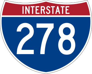
Interstate 278 (I-278) is an auxiliary Interstate Highway in New Jersey and New York in the United States. The road runs 35.62 miles (57.32 km) from US Route 1/9 (US 1/9) in Linden, New Jersey, northeast to the Bruckner Interchange in the New York City borough of the Bronx. The majority of I-278 is in New York City, where it serves as a partial beltway and passes through all five of the city's boroughs. I-278 follows several freeways, including the Union Freeway in Union County, New Jersey; the Staten Island Expressway (SIE) across Staten Island; the Gowanus Expressway in southern Brooklyn; the Brooklyn–Queens Expressway (BQE) across northern Brooklyn and Queens; a small part of the Grand Central Parkway in Queens; and a part of the Bruckner Expressway in the Bronx. I-278 also crosses multiple bridges, including the Goethals, Verrazzano-Narrows, Kosciuszko, and Robert F. Kennedy bridges.

<span class="mw-page-title-main">Independent Subway System</span> Defunct subway operator in New York City

The Independent Subway System was a rapid transit rail system in New York City that is now part of the New York City Subway. It was first constructed as the Eighth Avenue Line in Manhattan in 1932. It was originally also known as the Independent City-Owned Subway System (ICOSS) or the Independent City-Owned Rapid Transit Railroad (ICORTR).

<span class="mw-page-title-main">Proposed expansion of the New York City Subway</span>

Since the opening of the original New York City Subway line in 1904, and throughout the subway's history, various official and planning agencies have proposed numerous extensions to the subway system. The first major expansion of the subway system was the Dual Contracts, a set of agreements between the City of New York and the IRT and the BRT. The system was expanded into the outer reaches of the Bronx, Brooklyn, and Queens, and it provided for the construction of important lines in Manhattan. This one expansion of the system provided for a majority of today's system.

<span class="mw-page-title-main">Belt Parkway</span> Highway in New York

The Belt Parkway is the name given to a series of controlled-access parkways that form a belt-like circle around the New York City boroughs of Brooklyn and Queens. The Belt Parkway comprises three of the four parkways in what is known as the Belt System: the Shore Parkway, the Southern Parkway, and the Laurelton Parkway. The three parkways in the Belt Parkway are a combined 25.29 miles (40.70 km) in length. The Cross Island Parkway makes up the fourth parkway in the system, but is signed separately.

<span class="mw-page-title-main">Red Hook, Brooklyn</span> Neighborhood of Brooklyn in New York City

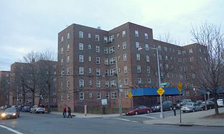
Red Hook is a neighborhood in western Brooklyn, New York City, New York, within the area once known as South Brooklyn. It is located on a peninsula projecting into the Upper New York Bay and is bounded by the Gowanus Expressway and the Carroll Gardens neighborhood on the northeast, Gowanus Canal on the east, and the Upper New York Bay on the west and south. A prosperous shipping and port area in the early 20th century, the area declined in the latter part of the century. Today it is home to the Red Hook Houses, the largest housing project in Brooklyn.

The IND Culver Line is a rapid transit line of the B Division of the New York City Subway, extending from Downtown Brooklyn south to Coney Island, Brooklyn, New York City, United States. The local tracks of the Culver Line are served by the F service, as well as the G between Bergen Street and Church Avenue. The express tracks north of Church Avenue are used by the <F> train during rush hours in the peak direction. The peak-direction express track between Ditmas Avenue and Avenue X has not seen regular service since 1987.

The IND 63rd Street Line and BMT 63rd Street Line, also referred to as the 63rd Street Crosstown, Crosstown Route, or Route 131-A, are two rapid transit lines of the B Division of the New York City Subway system. The two lines run under 63rd Street in the Upper East Side of Manhattan, with a cross-platform interchange at the Lexington Avenue–63rd Street station.

<span class="mw-page-title-main">Adam Giambrone</span>

Adam Giambrone is a Canadian transportation consultant and retired politician who served on Toronto City Council from 2003 to 2010, representing Ward 18 Davenport. Giambrone served as the chair of the Toronto Transit Commission (TTC) from 2006 to 2010. Following his tenure on council, Giambrone now works in transportation consulting.

<span class="mw-page-title-main">Bay Ridge Branch</span> Freight rail line in New York City

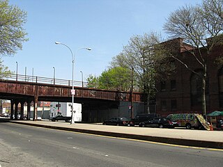
The Bay Ridge Branch is a rail line owned by the Long Island Rail Road (LIRR) and operated by the New York and Atlantic Railway in New York City. It is the longest freight-only line of the LIRR, connecting the Montauk Branch and CSX Transportation's Fremont Secondary at Glendale, Queens with the Upper New York Bay at Bay Ridge, Brooklyn.

<span class="mw-page-title-main">B61 and B62 buses</span> Bus routes in Brooklyn, New York

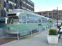
The Crosstown Line is a public transit line in Brooklyn, New York City, running along Van Brunt Street and Manhattan Avenue between Red Hook and Long Island City, Queens. Originally a streetcar line, it is now the B61 and the B62 bus routes. The northern section, the B62, is operated by MTA New York City Bus' Grand Avenue Depot in Maspeth, Queens, and the southern section is the B61, operated by MTA New York City Bus' Jackie Gleason Depot in Sunset Park. The entire route was a single line, the B61, until January 3, 2010; the B62 was previously a separate, parallel route between Downtown Brooklyn and Greenpoint, now part of the B43 route. The streetcar line, B61 and the original B62 previously operated from the now-closed Crosstown Depot in Greenpoint.

<span class="mw-page-title-main">Rockaway Beach Branch</span> Former Long Island Rail Road branch (closed 1962)

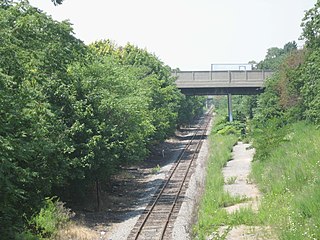
The Rockaway Beach Branch was a rail line owned and operated by the Long Island Rail Road in Queens, New York City, United States. The line left the Main Line at Whitepot Junction in Rego Park heading south via Ozone Park and across Jamaica Bay to Hammels in the Rockaways, turning west there to a terminal at Rockaway Park. Along the way it connected with the Montauk Branch near Glendale, the Atlantic Branch near Woodhaven, and the Far Rockaway Branch at Hammels.

<span class="mw-page-title-main">Transit City</span> Proposed Toronto public transit plan

Transit City was a plan for developing public transport in Toronto, Ontario, Canada. It was first proposed and announced on 16 March 2007 by Toronto mayor David Miller and Toronto Transit Commission (TTC) chair Adam Giambrone. The plan called for the construction of seven new light rail lines along the streets of seven priority transit corridors, which would have eventually been integrated with existing rapid transit, streetcar, and bus routes. Other transit improvements outlined in the plan included upgrading and extending the Scarborough RT line, implementing new bus rapid transit lines, and improving frequency and timing of 21 key bus routes. The plan integrated public transportation objectives outlined in the City of Toronto Official Plan, the TTC Ridership Growth Strategy and Miller's 2006 election platform.

The Waterfront West LRT (WWLRT) is a proposed streetcar line in Toronto, Ontario, Canada. The WWLRT is currently part of a City project called the Waterfront Transit Reset which also includes the East Bayfront LRT. The WWLRT was initially proposed as part of the Transit City plan to expand transit services offered by the Toronto Transit Commission that was announced March 16, 2007. The new line was to use existing parts of the Toronto streetcar system, extending from Union station to Long Branch Loop via Exhibition Place.

<span class="mw-page-title-main">Jamaica Avenue</span> Avenue in Brooklyn and Queens, New York

Jamaica Avenue is a major avenue in the New York City boroughs of Brooklyn and Queens, New York, in the United States. Jamaica Avenue's western end is at Broadway and Fulton Street, as a continuation of East New York Avenue, in Brooklyn's East New York neighborhood. Physically, East New York Avenue connects westbound to New York Avenue, where East New York Avenue changes names another time to Lincoln Road; Lincoln Road continues to Ocean Avenue in the west, where it ends. Its eastern end is at the city line in Bellerose, Queens, where it becomes Jericho Turnpike to serve the rest of Long Island. The section of Jamaica Avenue designated as New York State Route 25 runs from Braddock Avenue to the city line, where Jamaica Avenue becomes Jericho Turnpike.

<span class="mw-page-title-main">History of transportation in New York City</span>

Transportation in New York City has ranged from strong Dutch authority in the 17th century, expansionism during the industrial era in the 19th century and half of the 20th century, to cronyism during the Robert Moses era. The shape of New York City's transportation system changed as the city did, and the result is an expansive modern-day system of industrial-era infrastructure. New York City, being the most populous city in the United States, has a transportation system which includes one of the largest subway systems in the world; the world's first mechanically ventilated vehicular tunnel; and an aerial tramway.

<span class="mw-page-title-main">Utica Avenue</span> Avenue in Brooklyn, New York

Utica Avenue is a major avenue in Brooklyn, New York City, New York, United States. It is one of several named for the city of Utica in Upstate New York. It runs north–south and occupies the position of East 50th Street in the Brooklyn street grid, with East 49th Street to its west and East 51st Street to its east for most of its path. The south end of Utica Avenue is at Flatbush Avenue; its north end is at Fulton Street, beyond which it is continued by Malcolm X Boulevard in Bedford–Stuyvesant. Malcolm X Boulevard continues to Broadway, where it terminates on Broadway between Lawton Street and Hart Street.

<span class="mw-page-title-main">Staten Island Tunnel</span> Incomplete rail tunnel in New York City

The Staten Island Tunnel is an abandoned, incomplete railway and subway tunnel in Staten Island,New York City. It was intended to connect railways on Staten Island to the BMT Fourth Avenue Line of the New York City Subway, in Brooklyn, via a new crossing under the Narrows. Planned to extend 10,400 feet (3,200 m), the tunnel would have been among the world's longest at the time of its planning, in the late 19th and early 20th centuries.

East Bayfront LRT, also known as the Waterfront East LRT, is a planned Toronto streetcar line that would serve the East Bayfront and Port Lands areas in Toronto, Ontario, Canada. It would run from Union station under Bay Street and along Queens Quay and Cherry Street to a new Villiers Loop along Commissioners Street east of Cherry Street on Villiers Island. It would complement the existing 509 Harbourfront service that connects Union Station to Queens Quay west of Bay Street. Longer-term plans are to extend the East Bayfront line from Cherry and Commissioners Streets to the planned East Harbour Transit Hub along GO Transit's Lakeshore East line and the planned Ontario Line.

<span class="mw-page-title-main">Program for Action</span> New York City Subway expansion program (1968–1989)

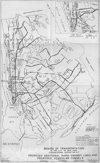
Metropolitan Transportation: A Program for Action, also known as simply the Program for Action, the Grand Design, or the New Routes Program, was a proposal in the mid-1960s for a large expansion of mass transit in New York City, created under then-Mayor John Lindsay. Originally published on February 29, 1968, the Program for Action was one of the most ambitious expansion plans in the history of the New York City Subway. The plan called for 50 miles (80 km) of tracks to be constructed, and more than 80% of the new trackage was to be built in the borough of Queens. The $2.9 billion plan also called for improvements to other modes of mass transit, such as the present-day Long Island Rail Road and Metro-North Railroad commuter rail systems, and further integration between mass transit and the New York City-area airport system.

<span class="mw-page-title-main">Farragut Houses</span> Public housing development in Brooklyn, New York

The Farragut Houses is a public housing project located in the downtown neighborhood of northwestern Brooklyn, New York City, bordering the Brooklyn Navy Yard. Farragut Houses is a property of New York City Housing Authority (NYCHA). The houses contain 3,272 residents who reside in ten buildings that are each 13 to 14 stories high.

References

  1. New York City Economic Development Corporation (August 2018). "Brooklyn Queens Connector Completion of Conceptual Design Report" (PDF). Retrieved October 2, 2019.
  2. 1 2 Geberer, Raanan (November 22, 2013). "De Blasio gives Diamond hope for Red Hook trolley plan". Brooklyn Daily Eagle . Retrieved September 29, 2014.
  3. 1 2 Calder, Rich (May 18, 2010). "Trolley good news for Red Hook rail plan". New York Post.
  4. "Red Hook Trolley Revival". Forgotten New York. March 13, 2012. Retrieved October 4, 2016.
  5. 1 2 "Brooklyn Streetcar Feasibility Study Final Report" (PDF). New York City Department of Transportation . August 2011. Retrieved January 28, 2018.
  6. 1 2 Guion, Payton (February 4, 2016). "New York mayor to propose $2.5B streetcar for underserved communities". The Independent. Retrieved February 4, 2016.
  7. Musumeci, Natalie (June 3, 2013). "Train buff's dreams streetcar desire will become reality". The Brooklyn Paper. Retrieved September 29, 2014.
  8. 1 2 Schwartz, Sam. "Brooklyn-Queens Connector". Sam Schwartz Transportation Consultants. Archived from the original on March 28, 2016. Retrieved February 9, 2016.
  9. 1 2 3 Rivoli, Dan (January 5, 2016). "$1.7B streetcar route desired for Brooklyn-Queens waterfront". www.nydailynews.com. NY Daily News. Retrieved February 3, 2016.
  10. Patel, Neel V. (February 4, 2016). "What's Up with NYC's Streetcar Plans? (Can New York City's mayor muster his inner Robert Moses?)". Inverse. Retrieved February 4, 2016.
  11. 1 2 3 4 5 6 7 8 9 10 11 12 "Brooklyn-Queens Connector – Streetcar/Light Rail Rapid Assessment" (PDF). Capitalnewyork.com. Friends of the Brooklyn-Queens Connector. Archived from the original (PDF) on April 23, 2016. Retrieved April 29, 2015.
  12. 1 2 Goldensohn, Rosa (February 4, 2016). "Sneak peek at de Blasio streetcar's likely Queens-Brooklyn route". Crain's New York Business. Retrieved February 8, 2016.
  13. Dwyer, Jim (February 4, 2016). "A Waterfront Route to Serve the Poor, Not Just the Wealthy". The New York Times. Retrieved February 8, 2016.
  14. 1 2 Fitzsimmons, Emma G. (February 19, 2016). "Streetcar Service Proposed by Mayor de Blasio May Require 2 New Bridges". The New York Times . Retrieved February 24, 2016.
  15. 1 2 3 4 Grynbaum, Michael M. (February 3, 2016). "Mayor de Blasio to Propose Streetcar Line Linking Brooklyn and Queens". The New York Times . Retrieved February 4, 2016.
  16. Honan, Katie (March 3, 2016). "Citywide Ferry Service to Launch in June 2017, Official Says". DNAinfo New York. Archived from the original on September 23, 2016. Retrieved September 22, 2016.
  17. Jorgensen, Jillian (February 4, 2016). "A Streetcar Named Independence: De Blasio Invests in Non-MTA Transit". Observer. Retrieved February 5, 2016.
  18. Calder, Rich; Furfaro, Danielle (February 3, 2016). "De Blasio to propose streetcar connecting Brooklyn, Queens". New York Post. Retrieved February 4, 2016.
  19. Rivoli, Dan (February 4, 2016). "Mayor de Blasio to propose Brooklyn-Queens waterfront streetcar at State of the City address". New York Daily News. Retrieved February 4, 2016.
  20. Davidson, Justin (February 5, 2016). "Why the Brooklyn-Queens Streetcar Is the Folly We Need". Daily Intelligencer. New York Media LLC. Retrieved February 9, 2016.
  21. Goldenberg, Sally; Rubinstein, Dana (February 3, 2016). "De Blasio expected to back Brooklyn-Queens streetcar proposal". www.capitalnewyork.com. Politico. Archived from the original on February 5, 2016. Retrieved February 4, 2016.
  22. Enman, Scott; Geberer, Raanan (February 12, 2016). "Long a dream of many, a streetcar line now grows in Brooklyn as real project". Brooklyn Daily Eagle. Everything Brooklyn Media. Retrieved February 4, 2016.
  23. Barone, Vincent (May 5, 2016). "Brooklyn Queens Connector support group hires exec". am New York. Retrieved May 9, 2016.
  24. Demara, Bruce (July 16, 2016). "Adam Giambrone hired as NYC transit consultant". Toronto Star . Retrieved July 18, 2016. Former city councillor and TTC chair Adam Giambrone has a new gig in New York City, overseeing the creation of a streetcar line along the waterfront linking the boroughs of Queens and Brooklyn.
  25. Davidson, Justin (July 16, 2016). "The Mayor's Brooklyn-Queens Streetcar Plan Gets a Czar". New York magazine . Retrieved July 16, 2016. Tall and athletic with a spiky crew cut and a Boy Scout demeanor, the 39-year-old Giambrone comes to the job with both experience and baggage — and with knowledge of New York sketchy enough that at one point during an interview he referred to the "Downtown East Side."
  26. Davidson, Terry (July 16, 2016). "Ex-TTC chair Adam Giambrone is New York City's new streetcar guru". Toronto Sun . Retrieved July 16, 2016. Adam Giambrone — the one-time mayoral candidate who was brought down by a sex scandal — is New York City's new streetcar guru.
  27. "Former TTC chair Adam Giambrone tapped to lead New York City streetcar project". CBC News. July 16, 2016. Retrieved July 16, 2016. Former Toronto politician Adam Giambrone has been appointed director of a new transit project in New York City. The project, called the BQX (Brooklyn Queens Connector) is a plan for a roughly 26-kilometre streetcar route that would run along the waterfront connecting those boroughs.
  28. Fitzsimmons, Emma G. (November 1, 2016). "City Unveils Possible Routes for Streetcar in Brooklyn and Queens". The New York Times. ISSN   0362-4331 . Retrieved November 6, 2016.
  29. 1 2 3 4 5 6 7 8 9 10 11 12 13 14 15 16 "BQX Fall 2016" (PDF). nycedc.com . Government of New York City. November 1, 2016. Retrieved November 6, 2016.
  30. 1 2 3 4 DeMause, Neil (February 7, 2017). "Light Rail's Dark Side: How Will NYC Pay for the BQX?". Village Voice. Retrieved February 7, 2017.
  31. Fenton, Reuven; Jaeger, Max (November 13, 2017). "A first look at the Brooklyn-Queens Connector". New York Post. Retrieved December 20, 2017.
  32. 1 2 Fox, Alison (November 13, 2017). "Group debuts BQX prototype despite lack of funding". am New York. Retrieved December 20, 2017.
  33. Rubinstein, Dana (April 14, 2017). "City memo suggests BQX may not be financially feasible after all". Politico PRO. Retrieved December 20, 2017.
  34. Calder, Rich (November 10, 2017). "De Blasio's Brooklyn-Queens trolley may be a pipe dream". New York Post. Retrieved December 20, 2017.
  35. Barone, Vincent (November 30, 2017). "Friends of the BQX director steps down from role". am New York. Retrieved April 11, 2018.
  36. 1 2 Fitzsimmons, Emma G. (April 10, 2018). "Is Mayor de Blasio's Brooklyn-Queens Streetcar Dead?". The New York Times. ISSN   0362-4331 . Retrieved April 11, 2018.
  37. Gonen, Yoav (April 6, 2018). "De Blasio admits Brooklyn-Queens trolley needs federal cash". New York Post. Retrieved April 11, 2018.
  38. 1 2 Cuba, Julianne (April 10, 2018). "Trouble connecting: Mayor, underlings publicly project different futures for waterfront streetcar scheme". Brooklyn Paper. Retrieved April 11, 2018.
  39. Cuba, Julianne (December 26, 2017). "Pick a lane: Transit honchos claim construction of mayor's BQX trolley will impede BQE repairs". Brooklyn Paper. Retrieved April 11, 2018.
  40. Warerkar, Tanay (August 30, 2018). "Brooklyn-Queens streetcar changes course, will cost more". Curbed NY. Retrieved August 31, 2018.
  41. 1 2 3 Barone, Vincent (August 30, 2018). "Shorter route, higher cost unveiled for BQX". am New York. Retrieved August 31, 2018.
  42. 1 2 3 Newman, Andy (August 30, 2018). "New Plan for City Streetcar: Shorter, Pricier and Not Coming Soon". The New York Times. Retrieved August 1, 2018.
  43. George, Michael (August 30, 2018). "Brooklyn-Queens Connector Streetcar Would Cost $2.7 Billion". NBC New York. Retrieved August 1, 2018.
  44. Plitt, Amy (February 6, 2019). "Brooklyn-Queens streetcar plan picks up speed". Curbed NY. Retrieved February 7, 2019.
  45. "Stayin' Alive: Plans for the Brooklyn-Queens streetcar are inching forward". The Real Deal New York. February 6, 2019. Retrieved February 7, 2019.
  46. "VHB lands contract for environmental review of proposed Brooklyn Queens Connector". Railway Track and Structures. February 6, 2019. Retrieved February 7, 2019.
  47. Berger, Paul (February 5, 2019). "Brooklyn-Queens Streetcar Plan Expected to Roll Into Next Phase". The Wall Street Journal. ISSN   0099-9660 . Retrieved September 15, 2020.
  48. "Brooklyn Queens Connector may be another victim of the pandemic". Railway Track and Structures. September 4, 2020. Retrieved September 15, 2020.
  49. Duggan, Kevin (September 3, 2020). "BQ-next: de Blasio says pricey tram line will be up to following mayor". Brooklyn Paper. Retrieved September 15, 2020.
  50. Rivoli, Dan (March 10, 2021). "With de Blasio Gone, What Will Happen to the Brooklyn-Queens Streetcar?". Spectrum News NY1 | New York City. Retrieved September 25, 2022.
  51. WABC (January 5, 2022). "Proposed transit line would connect Brooklyn, Queens to 17 subway lines, LIRR". ABC7 New York. Retrieved January 6, 2022.
  52. Fried, Ben (February 4, 2016). "4 Reasons a $2.5 Billion Brooklyn-Queens Streetcar Doesn't Add Up | Streetsblog New York City" . Retrieved February 4, 2016.
  53. Sanders, Anna (February 4, 2016). "Staten Island fumes at $2.5B Brooklyn-Queens streetcar plan". SILive.com. www.SILive.com. Retrieved February 4, 2016.
  54. Rojas, Rick (February 4, 2016). "Elation and Skepticism Over Proposal for Streetcars in Brooklyn and Queens". The New York Times. ISSN   0362-4331 . Retrieved February 8, 2016.
  55. Ellefson, Alex (February 8, 2016). "Southern Brooklyn Pols Slam Mayor's Street Car Plan: 'Transportation Must Benefit All NYers' – Bensonhurst's News Site". Bensonhurst Bean. Corner Media, Inc. Archived from the original on February 10, 2016. Retrieved February 8, 2016.
  56. Rose, Joel (February 23, 2016). "Revived Streetcars May Be On Track For Disappointment". NPR.org. Retrieved February 24, 2016.
  57. Rubenstein, Dana (April 22, 2016). "City gives new BQX streetcar details, and revs up outreach plan". Politico New York. Archived from the original on April 23, 2016. Retrieved April 29, 2016.
  58. Strauss, Steven (May 7, 2016). "Wanted: Real urban transit innovation". Daily News. New York. Retrieved May 23, 2016.