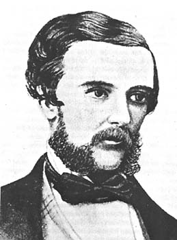
Edmund Besley Court Kennedy J. P. was an explorer in Australia in the mid nineteenth century. He was the Assistant-Surveyor of New South Wales, working with Sir Thomas Mitchell. Kennedy explored the interior of Queensland and northern New South Wales, including the Thomson River, the Barcoo River, Cooper Creek, and Cape York Peninsula. He died in December 1848 after being speared by Aboriginal Australians in far north Queensland near Cape York.

The Thomson River is a perennial river that forms part of the Lake Eyre Basin, situated in the central west and western regions of Queensland, Australia. Much of the course of the river comprises a series of narrow channels synonymous with the Channel Country and the Galilee subregion.

Normanton is an outback town and coastal locality in the Shire of Carpentaria, Queensland, Australia. At the 2021 census, the locality of Normanton had a population of 1,391 people, and the town of Normanton had a population of 1,326 people.

The Flinders River is the longest river in Queensland, Australia, at approximately 1,004 kilometres (624 mi). It was named in honour of the explorer Matthew Flinders. The catchment is sparsely populated and mostly undeveloped. The Flinders rises on the western slopes of the Great Dividing Range in North West Queensland and flows generally north-west through the Gulf Country, across a large, flat clay pan, before entering the Gulf of Carpentaria.

The Norman River is a river in the Gulf Country, Queensland, Australia. The river originates in the Gregory Range 200 km southeast of Croydon and flows 420 km northwest to the Gulf of Carpentaria. It is joined by three major tributaries, the Carron, Clara and Yappar Rivers. The river flows through Normanton before entering the Gulf of Carpentaria through the major fishing port of Karumba. The mouth of the river lies in the Gulf Plains Important Bird Area.

The Lockyer Creek is a creek in South East Queensland, Australia. A tributary of the Brisbane River, the creek is a major drainage system in the Lockyer Valley. Rising on the eastern slopes of the Great Dividing Range, the creek flows generally north-easterly for more than 100 kilometres (62 mi) before it reaches its confluence with the Brisbane River north-northeast of Lowood, and downstream from the Wivenhoe Dam. The creek is named after Edmund Lockyer.

The Palmer River is a river in Far North Queensland, Australia. The area surrounding the river was the site of a gold rush in the late 19th century which started in 1873.
The Gilbert River is located in Far North Queensland, Australia. When combined with the Einasleigh River, the river system is the largest river system in northern Australia.

The Johnstone River, comprising the North Johnstone River and the South Johnstone River, is a river system in Far North and North Queensland, Australia.

The Burke River is an ephemeral river in Central West Queensland, Australia. The river was named in memory of Robert O'Hara Burke of the Burke and Wills expedition.
The Calvert River is a river in the Northern Territory of Australia.

Jackey Jackey (1833–1854) is the name by which Galmahra, the Aboriginal Australian guide and companion to surveyor Edmund Kennedy was known. He survived Edmund Kennedy's fatal 1848 expedition into Cape York Peninsula and was subsequently formally recognized for heroic deeds by the then colony of New South Wales in words engraved on a solid silver breastplate or gorget which read as follows:
Presented by His Excellency Sir Charles Augustus FitzRoy K.D. Governor of New South Wales, to Jackey Jackey, an Aboriginal native of that colony. In testimony of the fidelity with which he followed the late Assistant Surveyor E.B.C. Kennedy, throughout the exploration of York Peninsula in the year 1848; the noble daring with which he supported that lamented gentleman, when mortally wounded by the Natives of Escape River, the courage with which after having affectionately tended the last moments of his Master, he made his way through hostile Tribes and an unknown Country, to Cape York; and finally the unexampled sagacity with which he conducted the succour that there awaited the Expedition to the rescue of the other survivors of it, who had been left at Shelbourne Bay.
The Clara River is a river in the Gulf Country of northwest Queensland, Australia.
The Gregory Range is a mountain range located in Far North Queensland, Australia.
The Settlement Creek is a creek in the Northern Territory and the state of Queensland, Australia.

The Gregory River is a river in the Northern Territory and the state of Queensland, Australia. The river is the largest perennial river in arid and semi-arid Queensland, one of the few permanently flowing rivers in the northwest of Queensland.

The Lynd River is a river located on the Cape York Peninsula in Far North Queensland, Australia.
The Jackey Jackey Creek, also often called Jacky Jacky Creek, is a creek in the Cape York Peninsula region of Far North Queensland, Australia.

Blackbull is a rural locality in the Shire of Croydon, Queensland, Australia. In the 2016 census Blackbull had a population of 3 people.
Karron is a locality in the Shire of Croydon, Queensland, Australia. In the 2016 census, Karron had a population of 0 people.
