
Mount Perry is a small town and locality in the North Burnett Region in southeastern Queensland, Australia. In the 2016 census, Mount Perry had a population of 538 people. The neighbourhood of Drummers Creek is in the locality.

Landsborough is a town and a locality in the Sunshine Coast Region, Queensland, Australia. In the 2016 census, Landsborough had a population of 3,812 people.

Canungra is a small rural town and locality in the Scenic Rim Region, Queensland, Australia. At the 2016 census, Canungra had a population of 1,229.

Calen is a small town and a coastal locality in the Mackay Region, Queensland, Australia. In the 2016 census, Calen had a population of 390 people.
Gowrie Junction is a rural locality in the Toowoomba Region, Queensland, Australia. It is north-west of Toowoomba. In the 2016 census, Gowrie Junction had a population of 2,120 people. The town of Gowrie is in the eastern part of the locality.

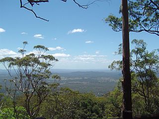
Tamborine Mountain is a 28 km2 (11 sq mi) plateau and locality in the Scenic Rim Region of South East Queensland, Australia. The name is of Aboriginal origin and is frequently misspelt as Tambourine but neither the name nor the place has any connection to the musical instrument. It is considered part of the Gold Coast hinterland and has a strong tourist industry.

Georgetown is a town and locality in the Shire of Etheridge, Queensland, Australia. In the 2016 census, Georgetown had a population of 348 people.

Lucinda is a coastal town and a locality in the Shire of Hinchinbrook, Queensland, Australia. In the 2016 census, Lucinda had a population of 406 people.

Cooran is a rural hinterland town and locality in the Shire of Noosa, Queensland, Australia. In the 2016 census the locality of Cooran had a population of 1,624 people.
Brandon is a rural town and locality in the Shire of Burdekin, Queensland, Australia. In the 2016 census, Brandon had a population of 1,094 people.
North Tamborine is a rural town in the locality of Tamborine Mountain in the Scenic Rim Region, Queensland, Australia.
Mount Tamborine is a town within the locality of Tamborine Mountain in South East Queensland, Australia.

Karara is a town and locality in the Darling Downs region within the Queensland, Australia. It is in the Southern Downs Region local government area. In the 2016 census, Karara had a population of 123 people.

Kumbia is a small town and locality in the South Burnett Region, Queensland, Australia. The town is located on the Bunya Highway, 231 kilometres (144 mi) north west of the state capital, Brisbane.
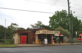
Peachester is a small town and locality in the Sunshine Coast Region, Queensland, Australia.
Adavale is a rural town and locality in the Shire of Quilpie, Queensland, Australia. In the 2016 census the locality of Adavale had a population of 93 people.

Gunalda is a town in the Gympie Region and a locality split between Gympie Region and Fraser Coast Region in Queensland, Australia. In the 2016 census, Gunalda had a population of 392 people.

Boyland is a locality in the Scenic Rim Region, Queensland, Australia. At the 2016 Australian Census, the locality recorded a population of 823.

Lockrose is a rural locality split between the Lockyer Valley Region and Somerset Region of Queensland, Australia. In the 2016 census, Lockrose had a population of 562 people.

Aubigny is a rural town and locality in the Toowoomba Region, Queensland, Australia. In the 2016 census, Aubigny had a population of 254 people.

