
Pigtown is a neighborhood in the southwest area of Baltimore, bordered by Martin Luther King Jr. Boulevard to the east, Monroe Street to the west, Russell Street to the south, and West Pratt Street to the north. The neighborhood acquired its name during the second half of the 19th century, when the area was the site of butcher shops and meat packing plants to process pigs transported from the Midwest on the B&O Railroad; they were herded across Ostend and Cross Streets to be slaughtered and processed.

Mondawmin is a neighborhood located in the Western district of Baltimore, Maryland, United States. The neighborhood is surrounded by Druid Hill Park, the Whitelock Community, and Lower Park Heights. Included within its boundaries are Frederick Douglass High School, and Mondawmin Mall. The Baltimore Metro Subway serves the neighborhood, with a station at Mondawmin Mall that is also a hub for many bus routes.
Morrell Park is a neighborhood community located in southwest Baltimore, Maryland, United States.

Ellwood Park is a neighborhood in the eastern part of Baltimore, Maryland. It is named for a small public park with a playground between Jefferson and Orleans Streets. The neighborhood extends from Linwood Avenue and Haven Street, between Monument Street and Fayette Street. It is contained within the 21205 and 21224 zip code.
O'Donnell Heights is a neighborhood named for a public housing development in the far southeastern part of the city of Baltimore, Maryland, United States. It is located south and east of Interstate 95, just west of the border with Baltimore County, and north of the St. Helena neighborhood.
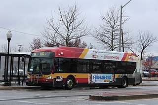
CityLink Orange is a bus route operated by the Maryland Transit Administration in Baltimore and its suburbs. The line currently runs from the Wal-Mart parking lot in Catonsville, Maryland east through downtown Baltimore to the Fox Ridge community in Essex, serving the corridors of Edmondson Avenue on the west side and Eastern Avenue on the east, and the communities of Edmondson Village, Allendale, Rosemont, Patterson Park, and Eastpoint, and is one of the most heavily used bus routes operated by the MTA.

Greenmount West is a neighborhood in the state-designated Station North Arts District of Baltimore. Its borders consist of Hargrove Alley to the west, Hoffman Street and the Amtrak railroad tracks to the south, the south side of North Avenue to the north, and Greenmount Avenue to the east. Residents in the area include a mix of low, middle and high income families, artists, commuters to Washington DC and working-class Baltimoreans with the majority of residents of African American descent.
Forest Park is a region of Northwest Baltimore, Maryland located west of Reisterstown Road, south of Northern Parkway, and east of the Baltimore City/County line. In Baltimore, the region is referred to by locals simply as "Forest Park" and includes the neighborhoods of Ashburton, Callaway-Garrison, Central Forest Park, Dolfield, Dorchester, East Arlington, Forest Park, Grove Park, Hanlon Longwood, Howard Park, Garwyn Oaks, Purnell, West Arlington, West Forest Park, and Windsor Hills.

Windsor Mill Road is a road that runs through parts of Baltimore, Maryland and its western suburb Woodlawn. The road starts as a one-way street named Edgewood Street, then makes a slight left corner and becomes Windsor Mill Road. The road, which is approximately 7+1⁄2 miles in length, runs parallel to nearby Liberty Road and Security Boulevard, and is often used as an alternative to these routes. Though Windsor Mill Road has no interchange with the Baltimore Beltway, it crosses over the highway, and this point is frequently mentioned in traffic reports.

Medfield is a neighborhood located in north Baltimore, Maryland, United States of America. It is located to the north of the trendy Hampden neighborhood and south of affluent Roland Park neighborhood. Its unofficial boundaries are Coldspring Lane to the north; Jones Falls Expressway to the west; Falls Road/Hickory Avenue to the east; and West 41st Street to the south.

Mosher is a neighborhood in the western part of Baltimore, Maryland. Its boundaries are the north side of Edmondson Avenue, the west side of Braddish Avenue, the east side of Poplar Grove, and the south side of Riggs Avenue. The neighborhood lies in the vicinity of Walbrook Junction, Coppin State University, Sandtown-Winchester, and Edmondson Village. Mosher is one of several neighborhoods that resisted the development of the "Road to Nowhere", now designated as US 40, along the Franklin Avenue corridor. The area was historically segregated, and largely occupied by European Americans, but transitioned during the early 1950s to become a predominantly African American area.

Mid-Govans is a community in northeast Baltimore, Maryland and part of the development of York Road, a historic Baltimore route to Pennsylvania. As the name suggests, Mid-Govans is located in the center of the larger neighborhood, Govans, with the rough boundaries of York Road to the west, Belvedere Avenue to the north, Midwood Avenue to the east, and Woodbourne Avenue to the south.
Woodbourne Heights, Baltimore is a community in northern Baltimore, Maryland. It is served by the Woodbourne Heights Community, the Woodbourne-McCabe Neighborhood and the Beauregard Neighborhood Associations.

Bridgeview/Greenlawn is a neighborhood in the western part of Baltimore, Maryland. Its boundaries are the north side of West Lafayette Street, the east side of Braddish Avenue, the west side of North Monroe Street, and the south side of Presstman Street. The neighborhood lies in the vicinity of Walbrook Junction, Coppin State University, Sandtown-Winchester, and Edmondson Village. Though the area was once considered middle-class, it has in the 20th century experienced economic depression, housing abandonment, crime and gang problems. It is populated largely by lower income African American residents and is a neighborhood where Bloods gang members are concentrated.
Lakeland is a neighborhood in south Baltimore, Maryland. Its borders are Annapolis Road on the east, the Baltimore city/county line to the south, a CSX/MARC Railroad line to the west, and the same railroad line to the north.
Waltherson is a neighborhood located in Northeast Baltimore, Maryland, United States that runs between Harford Road to Belair Road and from Hamilton Ave in the north and Southern Ave in the south. It was later expanded to include the neighborhood of Wilson Heights extending its boundaries along Belair Road to Moravia Road to achieve the boundaries currently seen on Baltimore City's CityView page.

Midtown-Edmondson is a mixed-use neighborhood in western Baltimore City developed mostly between the 1880s and the 1910s. The neighborhood is mainly composed of residential rowhouses, with a mixed-used business district along Edmondson Avenue, and industrial warehouses and buildings dotted along the CSX railroads that bound its western edge.

Catherine Anne Cesnik was a Roman Catholic religious sister and a teacher at Archbishop Keough High School in Baltimore, Maryland, United States. On November 7, 1969, Cesnik disappeared. Her body was discovered on January 3, 1970, near a garbage dump in the Baltimore suburb of Lansdowne. Her unsolved murder served as the basis for the Netflix documentary series The Keepers in 2017.
Rognel Heights is a neighborhood in the Southwest District of Baltimore, sandwiched between Hunting Ridge (west) and Edmondson Village (east) along Edmondson Avenue (south). Gwynns Falls/Leakin Park begins at the neighborhood's northern edge. Its boundaries are marked by Swann Avenue on the western edge, North Woodington Road on the east and Edmondson Avenue on the southern edge. The neighborhood of Uplands is located to the south of Rognel Heights, on the opposite side of Edmondson Avenue.
