Elk Hills, West Virginia | |
---|---|
Coordinates: 38°24′00″N81°34′24″W / 38.40000°N 81.57333°W | |
Country | United States |
State | West Virginia |
County | Kanawha |
Time zone | UTC-5 (Eastern (EST)) |
• Summer (DST) | UTC-4 (EDT) |
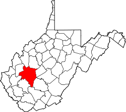
Elk Hills is an unincorporated community in central Kanawha County, West Virginia, United States. It lies on U.S. Route 119 along the Elk River, between the communities of Mink Shoals and Crede. [1]
Nutter Fort is a town in Harrison County, West Virginia, United States, incorporated in 1923. The town is a southeastern suburb of Clarksburg.
The Elk River is a tributary of the Kanawha River, 172 miles (277 km) long, in central West Virginia in the United States. Via the Kanawha and Ohio rivers, it is part of the watershed of the Mississippi River.
The West Fork River is a principal tributary of the Monongahela River, 103-mile (166 km) long, in north-central West Virginia, United States. Via the Monongahela and Ohio Rivers, it is part of the watershed of the Mississippi River, draining an area of 881 square miles (2,284 km²) on the unglaciated portion of the Allegheny Plateau.
Elk Creek is a tributary of the West Fork River, 29 miles (47 km) long, in north-central West Virginia, USA. Via the West Fork, Monongahela and Ohio Rivers, it is part of the watershed of the Mississippi River, draining an area of 121 square miles (310 km2) on the unglaciated portion of the Allegheny Plateau. The stream is believed to have been named by an 18th-century trapper and hunter named John Simpson, who encountered herds of elk along the stream.
Mill Creek is a tributary of the Ohio River, 29.4 miles (47.3 km) long, in western West Virginia in the United States. Via the Ohio, it is part of the watershed of the Mississippi River, draining an area of 234 square miles (610 km2) on the unglaciated portion of the Allegheny Plateau. According to the Geographic Names Information System, it has also been known historically as Big Mill Creek.
Davisville is an unincorporated community in Wood County, West Virginia, United States. Its elevation is 620 feet (189 m). It has a post office with the ZIP code 26142. The North Bend Rail Trail passes through the community.
Rock Castle is an unincorporated community in southwestern Jackson County, West Virginia, United States. It lies along Rock Castle Road, south of the city of Ripley, the county seat of Jackson County. Its elevation is 705 feet (215 m).
LeRoy is an unincorporated community in northeastern Jackson County, West Virginia, United States. It lies along Liverpool Road between Reedy and Sandyville, northeast of the city of Ripley, the county seat of Jackson County. Its elevation is 646 feet (197 m). Although LeRoy is unincorporated, it has a post office, with the ZIP code of 25252.
Kentuck is an unincorporated community in southeastern Jackson County, West Virginia, United States. It lies along Kentuck Road southeast of the city of Ripley, the county seat of Jackson County. Its elevation is 922 feet (281 m).
Kenna is an unincorporated community in southern Jackson County, West Virginia, United States. It lies along West Virginia Route 34 just west of its interchange with Interstate 77, south of the city of Ripley, the county seat of Jackson County. Its elevation is 787 feet (240 m). Although Kenna is unincorporated, it has a post office, with the ZIP code of 25248.
Given is an unincorporated community in southwestern Jackson County, West Virginia, United States. It lies at the intersection of Rock Castle, Shamblin Run, and Wolfe Creek Roads, south of the city of Ripley, the county seat of Jackson County. Its elevation is 689 feet (210 m). Although Given is unincorporated, it has a post office, with the ZIP code of 25245.
Flatwoods is an unincorporated community in northwestern Jackson County, West Virginia, United States. It lies at the intersection of Crooked Run and Harpold Roads, northwest of the city of Ripley, the county seat of Jackson County. Its elevation is 755 feet (230 m).
Sherman is an unincorporated community in northern Jackson County, West Virginia, United States, along the Ohio River. It lies along West Virginia Route 68 north of the city of Ravenswood. Its elevation is 600 feet (183 m).
Left Hand is an unincorporated community in southeastern Roane County, West Virginia, United States. It lies along West Virginia Route 36 southeast of the city of Spencer, the county seat of Roane County. Its post office is still active.
Neola is an unincorporated community in northeastern Greenbrier County, West Virginia, United States. It lies along West Virginia Route 92 north of the city of White Sulphur Springs. Its elevation is 2,037 feet (621 m).
Elk River is an unincorporated community in Humboldt County, California. It is located 2.25 miles (3.6 km) east-northeast of Fields Landing, at an elevation of 69 feet. All the residents of this neighborhood have Eureka, California addresses.
The Holly River is a tributary of the Elk River in central West Virginia in the United States. Via the Elk, Kanawha, and Ohio Rivers, it is part of the watershed of the Mississippi River, draining an area of 148 square miles (380 km2) in a rural region of the Allegheny Mountains. It is approximately 3.9 miles (6.3 km) long, or 28 miles (45 km) including its Left Fork. The river was named for the holly bushes along its course.
Twomile Creek is a tributary of the Kanawha River, 4.7 miles (7.6 km) long, in West Virginia in the United States. Via the Kanawha and Ohio rivers, it is part of the watershed of the Mississippi River, draining an area of 24.4 square miles (63 km2) on the unglaciated portion of the Allegheny Plateau, in the city of Charleston and its vicinity.
Point Pleasant Creek is a tributary of Middle Island Creek, 10.4 miles (16.7 km) long, in northwestern West Virginia in the United States. Via Middle Island Creek and the Ohio River, it is part of the watershed of the Mississippi River, draining an area of 60.5 square miles (157 km2) in a rural region on the unglaciated portion of the Allegheny Plateau.
The Elk Fork is a tributary of Point Pleasant Creek, 14.8 miles (23.8 km) long, in northwestern West Virginia in the United States. Via Point Pleasant Creek, Middle Island Creek, and the Ohio River, it is part of the watershed of the Mississippi River, draining an area of 21.1 square miles (55 km2) in a rural region on the unglaciated portion of the Allegheny Plateau.