Francestown, New Hampshire

Last updated

Francestown, New Hampshire
Town
FrancestownNH TownHall.jpg
Town hall
Hillsborough-Francestown-NH.png
Coordinates: 42°59′15″N71°48′45″W / 42.98750°N 71.81250°W / 42.98750; -71.81250
Country United States
State New Hampshire
County Hillsborough
Incorporated 1772
Government
   Select Board
  • Scot D. Heath, Chair
  • Charles M. Pyle III
  • Karen Fitzgerald
  Town AdministratorJamie Pike
Area
[1]
  Total30.4 sq mi (78.7 km2)
  Land29.8 sq mi (77.2 km2)
  Water0.6 sq mi (1.5 km2)  1.85%
Elevation
831 ft (253 m)
Population
 (2020) [2]
  Total1,610
  Density54/sq mi (20.9/km2)
Time zone UTC-5 (Eastern)
  Summer (DST) UTC-4 (Eastern)
ZIP code
03043
Area code 603
FIPS code 33-27140
GNIS feature ID0873598
Website www.francestownnh.org

Francestown is a town in Hillsborough County, New Hampshire, United States. The population was 1,610 at the 2020 census. [2] The village of Francestown, population 201 in 2020, is in the center of the town.

Contents

History

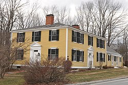
Levi Woodbury Homestead FrancestownNH LeviWoodburyHomestead.jpg
Levi Woodbury Homestead

Incorporated in 1772, Francestown takes its name from Frances Deering Wentworth, [3] the wife of colonial governor John Wentworth. There were 928 residents when the first census was taken in 1790. [4] For some time the town used its location on the Second New Hampshire Turnpike, the only route between Boston and Vermont, to collect a toll of one cent per mile from coaches and wagons. High-quality soapstone was mined in Francestown from 1792 to 1912. [5]

Geography

According to the United States Census Bureau, the town has a total area of 30.4 square miles (78.7 km2), of which 29.8 square miles (77.2 km2) are land and 0.58 square miles (1.5 km2) are water, making up 1.85% of the town. [1] The highest point in Francestown is the summit of Crotched Mountain, at 2,066 feet (630 m) above sea level, on the town's western border. Francestown lies fully within the Merrimack River watershed, [6] entirely via tributaries of the Piscataquog River. The town is crossed by state routes 47 and 136.

Demographics

Historical population
CensusPop.Note
1790 982
1800 1,35538.0%
1810 1,4517.1%
1820 1,4791.9%
1830 1,5404.1%
1840 1,308−15.1%
1850 1,114−14.8%
1860 1,082−2.9%
1870 932−13.9%
1880 9370.5%
1890 837−10.7%
1900 693−17.2%
1910 602−13.1%
1920 385−36.0%
1930 363−5.7%
1940 342−5.8%
1950 40518.4%
1960 49522.2%
1970 5256.1%
1980 83058.1%
1990 1,21746.6%
2000 1,48021.6%
2010 1,5625.5%
2020 1,6103.1%
U.S. Decennial Census [2] [7]

2000

As of the census [8] of 2000, there were 1,480 people, 552 households, and 418 families residing in the town. The population density was 49.1 inhabitants per square mile (19.0/km2). There were 656 housing units at an average density of 21.7 per square mile (8.4/km2). The racial makeup of the town was 97.30% White, 0.07% African American, 0.34% Native American, 0.27% Asian, 0.47% from other races, and 1.55% from two or more races. Hispanic or Latino of any race were 0.54% of the population.

There were 552 households, out of which 34.6% had children under the age of 18 living with them, 66.8% were married couples living together, 6.0% had a female householder with no husband present, and 24.1% were non-families. 17.0% of all households were made up of individuals, and 6.3% had someone living alone who was 65 years of age or older. The average household size was 2.68 and the average family size was 3.04.

In the town, the population was spread out, with 27.4% under the age of 18, 4.1% from 18 to 24, 28.7% from 25 to 44, 28.0% from 45 to 64, and 11.9% who were 65 years of age or older. The median age was 40 years. For every 100 females, there were 103.9 males. For every 100 females age 18 and over, there were 99.8 males.

The median income for a household in the town was $64,259, and the median income for a family was $71,471. Males had a median income of $50,521 versus $32,778 for females. The per capita income for the town was $28,942. About 1.2% of families and 3.0% of the population were below the poverty line, including 2.5% of those under age 18 and 3.5% of those age 65 or over.

2020

Between the 2010 and 2020 census, the population of Francestown increased from 1,562 to 1,610 residents. There were 624 households and 740 total housing units, with 93 vacant housing units. Of the 1,610 residents, the median household income was $102,721, compared with $83,626 for Hillsborough County. The poverty level was 2.8%, and exclusively effected residents over the age of 18. Of the 66% employment rate, 60.9% of workers were employed at private companies, 20.2% were self employed, 6.9% were employed as private non-profits, and 12% were employed by local, state, and federal government entities. [9]


Francestown presidential election results [10]
Year Democratic Republican Third parties Total VotesDifference
2020 51.39%59246.35% 5342.26% 261,1525.03%
2016 49.95%47147.08% 4442.97% 289432.86%
2012 51.19%53842.72% 4496.09% 641,0518.47%
2008 54.10%57445.15% 4790.75% 81,0618.95%
2004 48.71% 51050.81%5320.48% 51,0472.10%
2000 45.57% 39647.76%4156.67% 588692.19%
1996 47.51%37242.40% 33210.09% 797835.11%
1992 40.10%32035.59% 28424.31% 1947984.51%
1988 36.96% 25562.03%4281.01% 769025.07%
1988 37.57% 20762.07%3420.36% 255124.50%
1980 23.78% 12258.48%30017.74% 9151334.70%
1976 34.86% 14563.22%2631.92% 841628.37%
1972 25.94% 9773.26%2740.80% 337447.33%
1968 25.44% 7268.20%1936.36% 1828342.76%
1964 42.96% 11957.04%1580.00% 027714.08%
1960 17.91% 4882.09%2200.00% 026864.18%
1956 8.50% 2191.50%2260.00% 024783.00%
1952 6.36% 1893.64%2650.00% 028387.28%
1948 11.68% 2586.45%1851.87% 421474.77%
1944 23.03% 4176.97%1370.00% 017853.93%
1940 24.40% 5175.60%1580.00% 020951.20%
1936 26.26% 5273.23%1450.51% 119846.97%
1932 29.38% 5770.10%1360.52% 119440.72%

Notable people

Notable buildings

Old Francestown Town Hall and Historic District Francestown, New Hampshire - 5568892403.jpg
Old Francestown Town Hall and Historic District
George Holmes Bixby Memorial Library. Located at 52 Main St, Francestown, NH 03043. George Holmes Bixby Memorial Library, Francestown NH.jpg
George Holmes Bixby Memorial Library. Located at 52 Main St, Francestown, NH 03043.

Related Research Articles

<span class="mw-page-title-main">Hillsborough County, New Hampshire</span> County in New Hampshire, United States

Hillsborough County is the most populous county in the U.S. state of New Hampshire. As of the 2020 census, the population was 422,937, almost one-third the population of the entire state. Its county seats are Manchester and Nashua, the state's two biggest cities. Hillsborough is northern New England's most populous county as well as its most densely populated.

<span class="mw-page-title-main">Woodbury County, Iowa</span> County in Iowa, United States

Woodbury County is a county located in the U.S. state of Iowa. As of the 2020 census, the population was 105,941, making it the sixth-most populous county in Iowa. The county seat is Sioux City.

<span class="mw-page-title-main">Milan, New Hampshire</span> Town in New Hampshire, United States

Milan is a town in Coös County, New Hampshire, United States. The population was 1,358 at the 2020 census. It is part of the Berlin, NH-VT Micropolitan Statistical Area.

<span class="mw-page-title-main">Stratford, New Hampshire</span> Town in New Hampshire, United States

Stratford is a town located on the Connecticut River in Coös County, New Hampshire, United States. The population was 662 at the 2020 census, a decline from the figure of 746 tabulated in 2010. Within the town are the villages of North Stratford, Stratford Hollow, and Beatties. U.S. Route 3 passes through the center of town, as does the St. Lawrence and Atlantic Railroad, formerly a part of the Grand Trunk Railway.

<span class="mw-page-title-main">Bennington, New Hampshire</span> Town in New Hampshire, United States

Bennington is a town in Hillsborough County, New Hampshire, United States. The population was 1,501 at the 2020 census.

<span class="mw-page-title-main">Deering, New Hampshire</span> Town in New Hampshire, United States

Deering is a town in Hillsborough County, New Hampshire, United States. The population was 1,904 at the 2020 census.

<span class="mw-page-title-main">Greenfield, New Hampshire</span> Town in New Hampshire, United States

Greenfield is a town in Hillsborough County, New Hampshire, United States. The population was 1,716 at the 2020 census. Greenfield is home to the Crotched Mountain Rehabilitation Center, to Greenfield State Park, and to part of the Wapack Trail.

<span class="mw-page-title-main">Lyndeborough, New Hampshire</span> Town in New Hampshire, United States

Lyndeborough is a town in Hillsborough County, New Hampshire, United States. The population was 1,702 at the 2020 census.

<span class="mw-page-title-main">New Boston, New Hampshire</span> Town in New Hampshire, United States

New Boston is a town in Hillsborough County, New Hampshire, United States. The population was 6,108 at the 2020 census, up from 5,321 at the 2010 census. New Boston is home to the annual Hillsborough County Agricultural Fair and the Molly Stark Cannon. The 1743 cannon, which appears on the town seal, was given by General John Stark to the New Boston Artillery Company after the Battle of Bennington.

<span class="mw-page-title-main">Sharon, New Hampshire</span> Town in New Hampshire, United States

Sharon is a town in Hillsborough County, New Hampshire, United States. The population was 359 at the 2020 census. It was the long-time home to the Sharon Arts Center, a nonprofit which has ceased operations.

<span class="mw-page-title-main">Temple, New Hampshire</span> Town in New Hampshire, United States

Temple is a town in Hillsborough County, New Hampshire, United States. The population was 1,382 at the 2020 census. It is home to Temple Mountain State Reservation, formerly the Temple Mountain Ski Area.

<span class="mw-page-title-main">Weare, New Hampshire</span> Town in New Hampshire, United States

Weare is a town in Hillsborough County, New Hampshire, United States. The population was 9,092 at the 2020 census. It is close to two important New Hampshire cities, Manchester and Concord.

<span class="mw-page-title-main">Windsor, New Hampshire</span> Town in New Hampshire, United States

Windsor is a town in Hillsborough County, New Hampshire, United States. The population was 262 at the 2020 census. It is the location of the Wediko Children's Services Summer Program and of Windsor Mountain International, a summer adventure and travel camp founded in 1961. It is also the home of Windsor Hills Camp and Retreat Center, a ministry of the Church of the Nazarene.

<span class="mw-page-title-main">Goshen, New Hampshire</span> Place in New Hampshire, United States

Goshen is a town in Sullivan County, New Hampshire, United States. The population was 796 at the 2020 census.

<span class="mw-page-title-main">Lisbon, New Hampshire</span> Town in New Hampshire, United States

Lisbon is a town in Grafton County, New Hampshire, United States. The population was 1,621 at the 2020 census. Lisbon hosts an annual lilac festival on Memorial Day weekend.

<span class="mw-page-title-main">Antrim, New Hampshire</span> Town in New Hampshire, United States

Antrim is a town in Hillsborough County, New Hampshire, United States. The population was 2,651 at the 2020 census. The main village in the town, where 1,395 people lived at the 2020 census, is defined as the Antrim census-designated place (CDP) and is located at the intersection of U.S. Route 202 and New Hampshire Route 31. The town of Antrim also includes the villages of Antrim Center, North Branch, and Clinton Village.

<span class="mw-page-title-main">Hillsborough (CDP), New Hampshire</span> Census-designated place in New Hampshire, United States

Hillsborough is a census-designated place (CDP) and the main village in the town of Hillsborough in Hillsborough County, New Hampshire, United States. The population of the CDP was 2,156 at the 2020 census, out of 5,939 in the entire town.

<span class="mw-page-title-main">Hillsborough, New Hampshire</span> Town in New Hampshire, United States

Hillsborough, frequently spelled Hillsboro, is a town in Hillsborough County, New Hampshire, United States. The population was 5,939 at the 2020 census. The town is home to Fox State Forest and part of Low State Forest.

<span class="mw-page-title-main">Bennington (CDP), New Hampshire</span> Census-designated place in New Hampshire, United States

Bennington is a census-designated place (CDP) and the main village in the town of Bennington in Hillsborough County, New Hampshire, United States. The population of the CDP was 338 at the 2020 census, out of 1,501 in the entire town.

<span class="mw-page-title-main">Francestown (CDP), New Hampshire</span> Census-designated place in New Hampshire, United States

Francestown is a census-designated place (CDP) and the main village in the town of Francestown, Hillsborough County, New Hampshire, United States. As of the 2020 census, the population of the CDP was 201, out of 1,610 in the entire town.

References

  1. 1 2 "2021 U.S. Gazetteer Files – New Hampshire". United States Census Bureau. Retrieved December 6, 2021.
  2. 1 2 3 "Francestown town, Hillsborough County, New Hampshire: 2020 DEC Redistricting Data (PL 94-171)". U.S. Census Bureau. Retrieved December 6, 2021.
  3. Gannett, Henry (1905). The Origin of Certain Place Names in the United States. U.S. Government Printing Office. p. 130.
  4. "Francestown". New Hampshire Economic and Labor Market Information Bureau Profile. Retrieved April 25, 2014.
  5. Starbuck, David R. (1994). "An Introduction to New Hampshire Industrial Archeology". IA, The Journal of the Society for Industrial Archeology . 20 (1/2): 4–18. ISSN   0160-1040. JSTOR   40968279.
  6. Foster, Debra H.; Batorfalvy, Tatianna N.; Medalie, Laura (1995). Water Use in New Hampshire: An Activities Guide for Teachers. U.S. Department of the Interior and U.S. Geological Survey.
  7. "Census of Population and Housing". Census.gov. Retrieved June 4, 2016.
  8. "U.S. Census website". United States Census Bureau . Retrieved January 31, 2008.
  9. "Explore Census Data". data.census.gov. Retrieved November 21, 2021.
  10. "Election Results". sos.nh.gov.
  11. "BELL, Samuel, (1770 - 1850)". Biographical Directory of the United States Congress. Retrieved January 14, 2014.
  12. "BROWN, Titus, (1786 - 1849)". Biographical Directory of the United States Congress. Retrieved December 10, 2013.
  13. "Sylvester Roper". AMA Motorcycle Hall of Fame. Retrieved December 10, 2013.
  14. "Eri Davidson Woodbury". Military Times. Archived from the original on July 26, 2014. Retrieved July 18, 2014.
  15. "WOODBURY, Levi, (1789 - 1851)". Biographical Directory of the United States Congress. Retrieved December 10, 2013.