Germantown, Queensland

Last updated

Germantown
Queensland
Australia Queensland location map.svg
Red pog.svg
Germantown
Coordinates 17°38′38″S145°57′58″E / 17.6438°S 145.9661°E / -17.6438; 145.9661 (Germantown (centre of locality))
Population52 (2021 census) [1]
 • Density8.25/km2 (21.4/sq mi)
Postcode(s) 4871
Area6.3 km2 (2.4 sq mi)
Time zone AEST (UTC+10:00)
Location
LGA(s) Cassowary Coast Region
State electorate(s) Hill
Federal division(s) Kennedy
Suburbs around Germantown:
Camp Creek Camp Creek Basilisk
Utchee Creek Germantown Basilisk
Mena Creek Mena Creek Basilisk

Germantown is a rural locality in the Cassowary Coast Region, Queensland, Australia. [2] In the 2021 census, Germantown had a population of 52 people. [1]

Contents

Geography

The locality is bounded to the north-west by Utchee Creek, to the north by Camp Creek Road, to the east by Stewart Creek, and to the south by the watercourse Mena Creek. [3]

The Innisfail Japoon Road enters the locality from the north (the locality Camp Creek) and exits to the south-west (the locality Mena Creek). [3]

The land use is agricultural, a mix of crop growing (with sugarcane being widely grown) and grazing on native vegetation. [3] There is a cane tramway network through the locality to transport the harvested sugarcane to the South Johnstone sugar mill. [3]

History

After the First World War, many German settlers settled here (hence the place name). It was mainly a sugar cane farming community until the early 2010s, at which time a large portion of Germantown was converted from sugar cane into open cattle country. Another portion of Germantown was recently converted into a Banana farm.[ citation needed ]

Demographics

In the 2016 census, Germantown had a population of 64 people. [4]

In the 2021 census, Germantown had a population of 52 people. [1]

Education

There are no schools in Germantown. The nearest government primary school is Mena Creek State School in neighbouring Mena Creek to the south. The nearest government secondary school is Innisfail State College in Innisfail Estate to the north-east. [5]

Related Research Articles

Mundoo is a rural town and locality in the Cassowary Coast Region, Queensland, Australia. In the 2016 census the locality of Mundoo had a population of 224 people.

<span class="mw-page-title-main">Mena Creek, Queensland</span> Suburb of Cassowary Coast Region, Queensland, Australia

Mena Creek is a rural locality in the Cassowary Coast Region, Queensland, Australia. In the 2016 census, Mena Creek had a population of 244 people.

<span class="mw-page-title-main">Mourilyan Harbour</span> Suburb of Cassowary Coast Region, Queensland, Australia

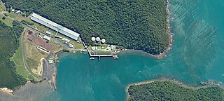
Mourilyan Harbour is a coastal locality and harbour within the Cassowary Coast Region, Queensland, Australia. In the 2021 census, Mourilyan Harbour had a population of 142 people.

<span class="mw-page-title-main">Goondi, Queensland</span> Suburb of Cassowary Coast Region, Queensland, Australia

Goondi is a locality in the Cassowary Coast Region, Queensland, Australia.

<span class="mw-page-title-main">Eubenangee, Queensland</span> Suburb of Cairns Region, Queensland, Australia

Eubenangee is a coastal locality split between the Cairns Region and the Cassowary Coast Region, Queensland, Australia. In the 2021 census, Eubenangee had a population of 247 people.

Coorumba is a rural locality in the Cassowary Coast Region, Queensland, Australia. In the 2021 census, Coorumba had a population of 137 people.

<span class="mw-page-title-main">Daradgee, Queensland</span> Town in Queensland, Australia

Daradgee is a rural town and locality in the Cassowary Coast Region, Queensland, Australia. In the 2016 census, Daradgee had a population of 74 people.

No. 5 Branch is a rural locality in the Cassowary Coast Region, Queensland, Australia. In the 2021 census, No. 5 Branch had "no people or a very low population".

Wangan is a town and a locality in the Cassowary Coast Region, Queensland, Australia. In the 2021 census, the locality of Wangan had a population of 612 people.

New Harbourline is a rural locality in the Cassowary Coast Region, Queensland, Australia. In the 2021 census, New Harbourline had a population of 218 people.

Bombeeta is a rural locality in the Cassowary Coast Region, Queensland, Australia. In the 2021 census, Bombeeta had a population of 147 people.

Mighell is a rural locality in the Cassowary Coast Region, Queensland, Australia. In the 2021 census, Mighell had a population of 363 people.

Cullinane is a rural locality in the Cassowary Coast Region, Queensland, Australia. In the 2021 census, Cullinane had a population of 551 people.

Innisfail Estate is a semi-rural locality in the Cassowary Coast Region, Queensland, Australia. In the 2021 census, Innisfail Estate had a population of 1,454 people.

<span class="mw-page-title-main">Cowley, Queensland</span> Suburb of Cassowary Coast Region, Queensland, Australia

Cowley is a rural locality in the Cassowary Coast Region, Queensland, Australia. In the 2021 census, Cowley had a population of 82 people.

Goolboo is a rural locality in the Cassowary Coast Region of Queensland, Australia. In the 2021 census, Goolboo had a population of 25 people.

Currajah is a rural locality in the Cassowary Coast Region, Queensland, Australia. In the 2021 census, Currajah had a population of 57 people.

Hudson is a rural locality in the Cassowary Coast Region, Queensland, Australia. In the 2021 census, Hudson had a population of 238 people.

No. 6 Branch is a rural locality in the Cassowary Coast Region, Queensland, Australia. In the 2021 census, No. 6 Branch had a population of 73 people.

Sundown is a rural locality in the Cassowary Coast Region, Queensland, Australia. In the 2021 census, Sundown had a population of 145 people.

References

  1. 1 2 3 Australian Bureau of Statistics (28 June 2022). "Germantown (SAL)". 2021 Census QuickStats. Retrieved 28 February 2023. OOjs UI icon edit-ltr-progressive.svg
  2. "Germantown – locality in Cassowary Coast Region (entry 45700)". Queensland Place Names. Queensland Government . Retrieved 29 October 2019.
  3. 1 2 3 4 "Queensland Globe". State of Queensland . Retrieved 10 September 2023.
  4. Australian Bureau of Statistics (27 June 2017). "Germantown (SSC)". 2016 Census QuickStats. Retrieved 20 October 2018. OOjs UI icon edit-ltr-progressive.svg
  5. "Layers: Locality; Schools and school catchments". Queensland Globe. Queensland Government . Retrieved 10 September 2023.