Hanoverton Canal Town District

Last updated

Hanoverton Canal Town District
Brick Row (1831) Hanoverton, Ohio.JPG
Brick Row (1831), April 2016
USA Ohio location map.svg
Red pog.svg
Usa edcp location map.svg
Red pog.svg
LocationU.S. 30, Hanoverton, Ohio
Coordinates 40°45′08″N80°56′07″W / 40.75222°N 80.93528°W / 40.75222; -80.93528
Area23 acres (9.3 ha)
Built1817
NRHP reference No. 77001050 [1]
Added to NRHPAugust 3, 1977

The Hanoverton Canal Town District is a historic district in Hanoverton, Ohio, United States, that is listed on the National Register of Historic Places (NRHP. [1]

Contents

Description

Hanoverton Presbyterian Church, April 2016 Hanoverton Ohio Presbyterian Church.JPG
Hanoverton Presbyterian Church, April 2016

The district covers a 23-acre (9.3 ha) area along U.S. Route 30. It is characterized by examples of canal-era architecture of the early to mid-19th century. [2] The town of Hanoverton was settled and platted in 1813. [3]

Within the district, there are 30 brick and frame houses built between 1817 and 1874, which have remained unchanged over the years. The simple frame houses were originally built during the construction of the Hanoverton and the Sandy and Beaver Canal. [2] [4]

The district was listed on the NRHP August 3, 1977. [1]

See also

Related Research Articles

<span class="mw-page-title-main">Columbiana County, Ohio</span> County in Ohio, United States

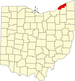
Columbiana County is a county located in the U.S. state of Ohio. As of the 2020 census, the population was 101,877. The county seat is Lisbon and its largest city is Salem. The county name is derived from the explorer of the Americas, Christopher Columbus.

<span class="mw-page-title-main">Hanoverton, Ohio</span> Village in Ohio, United States

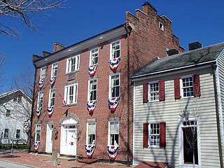
Hanoverton is a village in western Columbiana County, Ohio, United States. The population was 354 at the 2020 census. It is part of the Salem micropolitan area, 23 miles (37 km) miles east of Canton and 28 miles (45 km) southwest of Youngstown.

<span class="mw-page-title-main">Bellows Falls, Vermont</span> Village in Vermont, United States

Bellows Falls is an incorporated village located in the town of Rockingham in Windham County, Vermont, United States. The population was 2,747 at the 2020 census. Bellows Falls is home to the Green Mountain Railroad, a heritage railroad; the annual Roots on the River Festival; and the No Film Film Festival.

<span class="mw-page-title-main">National Register of Historic Places listings in Sullivan County, New York</span>

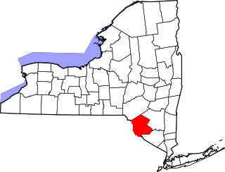
List of the National Register of Historic Places listings in Sullivan County, New York

<span class="mw-page-title-main">Hanover Township, Columbiana County, Ohio</span> Township in Ohio, United States

Hanover Township is one of the eighteen townships of Columbiana County, Ohio, United States. The 2020 census reported 3,459 people living in the township.

<span class="mw-page-title-main">Cape May Historic District</span> Historic district in New Jersey, United States

The Cape May Historic District is an area of 380 acres (1.5 km2) with over 600 buildings in the resort town of Cape May, Cape May County, New Jersey. The city claims to be America's first seaside resort and has numerous buildings in the Late Victorian style, including the Eclectic, Stick, and Shingle styles, as well as the later Bungalow style, many with gingerbread trim. According to National Park Service architectural historian Carolyn Pitts, "Cape May has one of the largest collections of late 19th century frame buildings left in the United States... that give it a homogeneous architectural character, a kind of textbook of vernacular American building."

<span class="mw-page-title-main">National Register of Historic Places listings in Stark County, Ohio</span>

This is a list of the National Register of Historic Places listings in Stark County, Ohio.

<span class="mw-page-title-main">National Register of Historic Places listings in Mahoning County, Ohio</span>

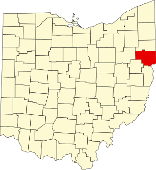
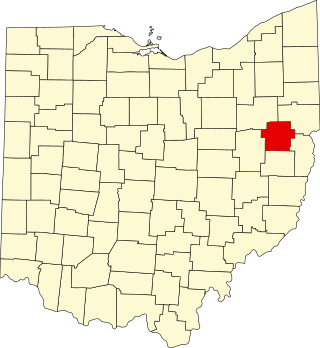
This is a list of the National Register of Historic Places listings in Mahoning County, Ohio.

<span class="mw-page-title-main">National Register of Historic Places listings in Lake County, Ohio</span>

This is a list of the National Register of Historic Places listings in Lake County, Ohio.

<span class="mw-page-title-main">National Register of Historic Places listings in Columbiana County, Ohio</span>

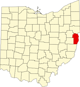
This is a list of the National Register of Historic Places listings in Columbiana County, Ohio.

<span class="mw-page-title-main">National Register of Historic Places listings in Jefferson County, Ohio</span>

This is a list of the National Register of Historic Places listings in Jefferson County, Ohio.

<span class="mw-page-title-main">National Register of Historic Places listings in Cleveland</span> List of historic sites in Cleveland, Ohio, US

This is a list of the National Register of Historic Places listings in Cleveland, Ohio.

<span class="mw-page-title-main">National Register of Historic Places listings in Summit County, Utah</span>

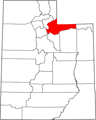
This is a list of the National Register of Historic Places listings in Summit County, Utah.

<span class="mw-page-title-main">National Register of Historic Places listings in Carroll County, Ohio</span>

This is a list of the National Register of Historic Places listings in Carroll County, Ohio.

<span class="mw-page-title-main">National Register of Historic Places listings in Southington, Connecticut</span>

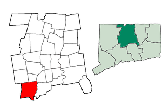
This is a list of the National Register of Historic Places listings in Southington, Connecticut.

<span class="mw-page-title-main">Gaston's Mill-Lock No. 36, Sandy and Beaver Canal District</span> Historic district in Ohio, United States

Gaston's Mill-Lock No. 36, Sandy and Beaver Canal District, is a historic district listed in the National Register of Historic Places. The district is located within Beaver Creek State Park, approximately 1 mile south of Clarkson, Ohio. Gaston's Mill was constructed in 1837 and was powered by Little Beaver Creek. Lock 36 was one of 90 locks on the Sandy and Beaver Canal. Construction of this canal began in 1834 but was not completed until 1848.

This is a list of the National Register of Historic Places listings in Cuyahoga Valley National Park.

<span class="mw-page-title-main">Broad Street (Columbus, Ohio)</span> East-west street in Columbus, Ohio

Broad Street is a major thoroughfare in Central Ohio, predominantly in Franklin County and Columbus. It stretches east from West Jefferson at Little Darby Creek to Pataskala. The street is considered one of Columbus's two main roads, along with High Street.

References

  1. 1 2 3 "National Register Information System". National Register of Historic Places . National Park Service. July 9, 2010.
  2. 1 2 "Hanoverton Canal Town District". historic and notable landmarks of the u.s. LandmarkHunter.com. Retrieved August 14, 2011.
  3. "Historical Sketch of Columbiana County". columbianacounty.org. Retrieved August 14, 2011.
  4. Editorial Staff (2008). Ohio Historic Places Dictionary. North American Book Dist LLC. p. 161. ISBN   978-1-878592-70-5.

Commons-logo.svg Media related to Hanoverton Canal Town District at Wikimedia Commons