
Hope Valley is a village and census-designated place (CDP) in the town of Hopkinton in Washington County, Rhode Island, United States. The population of the CDP was 1,612 at the 2010 census. Hope Valley is the largest village in Hopkinton and the town's principal commercial center. While the village of Hope Valley is located in Hopkinton, its zip code, 02832, extends into the neighboring town of Richmond.

Hopkinton is a town in Washington County, Rhode Island. The population was 8,398 at the 2020 census.
Westerly is a town on the southwestern coastline of Washington County, Rhode Island, first settled by English colonists in 1661 and incorporated as a municipality in 1669. It is a beachfront community on the south shore of the state with a population of 23,359 as of the 2020 census.

Hopkinton is a town in Middlesex County, Massachusetts, United States, 25 miles (40 km) west of Boston. The town is best known as the starting point of the Boston Marathon, held annually on Patriots' Day each April, and as the headquarters for the Dell EMC corporation.

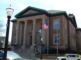
Wakefield is a village in the town of South Kingstown, Rhode Island, United States, and the commercial center of South Kingstown. Together with the village of Peace Dale, it is treated by the U.S. Census as a component of the census-designated place identified as Wakefield-Peacedale, Rhode Island. West Kingston, another South Kingstown village, was the traditional county seat of Washington County. Since 1991, the Washington County Courthouse has been in Wakefield. The Sheriff's Office which handles corrections is also in Wakefield.

Kingston is a village and a census-designated place within the town of South Kingstown in Washington County, Rhode Island, United States, and the site of the main campus of the University of Rhode Island. The population was 6,974 at the 2010 census. Much of the village center is listed on the National Register of Historic Places as Kingston Village Historic District. It was originally known as Little Rest.

Saunderstown is a small village and historic district in the towns of Narragansett and North Kingstown in Washington County, Rhode Island, United States. Saunderstown has its own post office with the ZIP Code of 02874, which also includes a small part of South Kingstown. Its population is 6,245.
Ironstone is an historic village,, in the township of Uxbridge, Massachusetts, United States. It derived its name from plentiful bog iron found here which helped Uxbridge to become a center for three iron forges in the town's earliest settlement. South Uxbridge has historic sites, picturesque weddings, hospitality, industrial and distribution centers, and the new Uxbridge High School. This community borders North Smithfield, and Burrillville, Rhode Island, and Millville, Massachusetts. South Uxbridge receives municipal services from Uxbridge, for fire, police, EMS, School district, public works, and other services. There is a South Uxbridge fire station of the Uxbridge fire department. Worcester's Judicial District includes Uxbridge District Court. Ironstone appears on the Blackstone U.S. Geological Survey Map. Worcester County is in the Eastern time zone and observes DST.

Arnold Mills Historic District is a historic district encompassing a modest 19th-century mill village in eastern Cumberland, Rhode Island. The district lies along the Nate Whipple Highway and Sneech Pond Road, south of the Arnold Mills Reservoir. Sneech Pond Road was formerly the major east-west highway through the area prior to the construction of the Nate Whipple Highway in the 1960s. The Arnold Mills village is in part bisected by Abbott Run, the stream which serves as the outlet of the reservoir; Sneech Pond Road crosses the run on an early 20th-century steel Pratt pony truss, now closed to vehicular traffic. The houses along this road generally date from the late 18th to mid-19th century, and mainly reflect Federal and Greek Revival styling. The most prominent structure in the district is the Arnold Mills United Methodist Church, located at the western end of the district on Nate Whipple Highway; it was built 1825-27 and remodeled in 1846.

The Wanskuck Historic District is a historic district in the city of Providence, Rhode Island encompassing a mill village with more than two hundred years of history. As early as the mid-18th century, mills stood on the West River in northern Providence, a development which continued with the rise of industrialization in the 19th century. The mill village of Wanskuck is organized around three thoroughfares: Branch Street, Veazie Street, and Woodward Road, and is roughly bounded on the east by Louisquisset Pike and to the northwest by the city line with North Providence. The West River runs through the district, with its banks lined by two late-19th-century mill complexes. The village area includes a variety of examples of mill worker housing, from duplexes to rowhouses, as well as two church complexes and a community hall built in 1884 by the Wanskuck Company.
Black Farm, also known as the Isaac Collins Farm, is a historic farm in Hopkinton, Rhode Island bounded by Woodville Alton Road and Wood Road. The 264-acre (107 ha) plot was developed by John Collins beginning in 1710 and saw agricultural use for over 200 years. The main house dates to the late 18th century, and is a 1-1/2 story gambrel-roofed post-and-beam structure. Outbuildings include 19th century barns, a corn crib, and a guest cottage added in the 1930s. Set some distance off from this complex is the foundational remains of what was probably an ice house; it consists of granite blocks and is eight feet high.

The Tomaquag Rock Shelters (RI-HP-1) are a prehistoric rock shelter site off Maxson Hill Road in Hopkinton, Rhode Island. The shelters are located under two east-facing granite outcrops in the valley drained by Tomaquag Brook. Nathan Kaye discovered the shelters in the late 1950s. Materials recovered from test excavations resulted in dating one shelter to 800 BC and the other to AD 800. Materials recovered include projectile points, stone knives, and evidence of stone tool construction. Both sites included evidence pointing to the presence of a fire pit.

Wyoming is a village and census-designated place on the Wood River in southern Rhode Island, primarily in the town of Richmond, Rhode Island, but extending north across the river into the town of Hopkinton, Rhode Island. The population was 270 at the 2010 census. It is the site of the Wyoming Village Historic District and a post office assigned ZIP code 02898.

The Rice City Historic District is a historic district in Coventry, Rhode Island. It encompasses the 19th-century village of Rice City, extending along Plainfield Pike for several miles between Sisson Road and Gibson Hill Road in the northwestern part of Coventry. The main village center is at the junction of the Pike and Vaughn Hollow Road, and there is a former industrial and commercial center at Fairbank's Corner, the junction with Flat River Road. The architecture of the district is predominantly rural and residential, with Greek Revival and Federal style housing predominating. Rice City village is dominated by Rice Tavern, which used to serve travelers on their way to Connecticut, as well as the Rice City Church (1846), the Democrat Schoolhouse, and the Obadiah Potter House (1846), all a short way up Vaughn Hill Road. At the western edge of the district, the modern Pike alignment diverges from the historical one at Gibson Hill Road, where the foundational remnants of agricultural settlements may be found.

Plainfield Street Historic District is a historic district in Plainfield, Connecticut that encompasses the historic area of Plainfield Village, the town center of Plainfield. The district is linear, being located along Route 12 between Railroad Avenue and Route 14A. It has been the center of the town's civic life since its settlement in the early 18th century, and includes two centuries of architectural styles. The district was listed on the National Register of Historic Places in 1991.
The Sterling Hill Historic District encompasses a well-preserved early 19th-century rural village center on western edge of the town of Sterling, Connecticut. Centered at the junction of Plainfield Pike and Sterling Hill Road, it consists of a cluster of 19th and early 19th-century houses, and a church. Unlike other period villages, it has largely been unaffected by later development. It was listed on the National Register of Historic Places in 1986.

Foster Center is a village in the town of Foster, Rhode Island, United States. It was listed as a census-designated place (CDP) in 2010, with a population of 355. Historic elements of the village are included in the Foster Center Historic District, which was added to the National Register of Historic Places on May 11, 1974. The district features various colonial and Greek Revival houses as well as the still functioning town building from the late 18th century.
Canonchet is a small village in the town of Hopkinton in the U.S. state of Rhode Island.
Hopkinton is a census-designated place (CDP) in Washington County, Rhode Island, United States, comprising the central village in the town of Hopkinton. It was first listed as a CDP prior to the 2020 census. The village is also known as Hopkinton City, and the center of the village comprises the Hopkinton City Historic District.

The Westbrook Town Center Historic District encompasses the historic town center of Westbrook, Connecticut. Roughly linear in shape, the district extends along the Boston Post Road, with its focal center at the junction with Essex Road. The area has been a center of civic activity since the early 18th century, even though Westbrook was not incorporated until 1840, and has residential, commercial, civic, and religious architecture covering three centuries. The district was listed on the National Register of Historic Places in 2017.


