Kingsgate, Kirkland, Washington

Last updated
Kingsgate, Washington
Neighborhood
King County Washington Incorporated and Unincorporated areas Kingsgate Highlighted.svg
Location of Kingsgate, Washington
Coordinates: 47°43′35″N122°10′27″W / 47.72639°N 122.17417°W / 47.72639; -122.17417 Coordinates: 47°43′35″N122°10′27″W / 47.72639°N 122.17417°W / 47.72639; -122.17417
Country United States
State Washington
County King
City Kirkland
Area
  Total2.3 sq mi (6.0 km2)
  Land2.3 sq mi (6.0 km2)
  Water0.0 sq mi (0.0 km2)
Elevation
325 ft (99 m)
Population
 (2010)
  Total13,065
  Density5,255.7/sq mi (2,029.2/km2)
Time zone UTC-8 (Pacific (PST))
  Summer (DST) UTC-7 (PDT)
ZIP code
98034
Area code 425
FIPS code 53-35835 [1]
GNIS feature ID1509742 [2]

Kingsgate is a neighborhood of Kirkland, Washington, United States. It was annexed by Kirkland on June 1, 2011. [3] [4] Prior to the annexation, Kingsgate was a census-designated place (CDP).

Contents

Based on 2010 US Census data, Kingsgate ranks 70th of 522 evaluated areas in the state of Washington by per capita income.

Geography

Kingsgate is located at 47°43′35″N122°10′27″W / 47.72639°N 122.17417°W / 47.72639; -122.17417 (47.726320, -122.174184). [5]

According to the United States Census Bureau, the CDP had a total area of 2.3 square miles (6.0 km2), all of it land.

Demographics

Historical population
CensusPop.Note
1980 12,652
1990 14,25912.7%
2000 12,222−14.3%
2010 13,0656.9%
source: [6]

As of the census [1] of 2000, there were 12,222 people, 4,314 households, and 3,157 families residing in the CDP. The population density was 5,255.7 people per square mile (2,025.3/km2). There were 4,424 housing units at an average density of 1,902.4/sq mi (733.1/km2). The racial makeup of the CDP was 79.95% White, 1.63% African American, 0.61% Native American, 11.63% Asian, 0.24% Pacific Islander, 1.82% from other races, and 4.12% from two or more races. Hispanic or Latino of any race were 5.65% of the population.

There were 4,314 households, out of which 37.9% had children under the age of 18 living with them, 58.0% were married couples living together, 11.4% had a female householder with no husband present, and 26.8% were non-families. 20.0% of all households were made up of individuals, and 3.8% had someone living alone who was 65 years of age or older. The average household size was 2.83 and the average family size was 3.26.

In the CDP, the population was spread out, with 27.9% under the age of 18, 7.9% from 18 to 24, 33.8% from 25 to 44, 23.7% from 45 to 64, and 6.8% who were 65 years of age or older. The median age was 34 years. For every 100 females, there were 97.6 males. For every 100 females age 18 and over, there were 93.8 males.

The median income for a household in the CDP was $65,046, and the median income for a family was $70,548. Males had a median income of $50,765 versus $33,262 for females. The per capita income for the CDP was $26,543. About 3.2% of families and 4.9% of the population were below the poverty line, including 6.9% of those under age 18 and 5.5% of those age 65 or over.

Related Research Articles

<span class="mw-page-title-main">Olympia Heights, Florida</span> Census-designated place in Florida, United States

Olympia Heights is a census-designated place in Miami-Dade County, Florida, United States. The population was 12,873 at the 2020 census.

High Point was a census-designated place (CDP) in Palm Beach County, Florida, United States. The population was 2,191 at the 2000 census. The CDP was removed from the 2010 census. Although it is still unincorporated, it is within Delray Beach's "future annexation area."

<span class="mw-page-title-main">Kirkland, North Carolina</span> CDP in North Carolina, United States

Kirkland, more commonly known as Porter's Neck, was a census-designated place (CDP) in New Hanover County, North Carolina, United States. Redesignated as Porters Neck CDP for the 2010 census, the population was 6,204. It is part of the Wilmington Metropolitan Statistical Area.

Sandy Level is a census-designated place (CDP) in Henry County, Virginia, United States. The population was 484 at the 2010 census, which was a significant decrease from the 689 reported in 2000. It is part of the Martinsville Micropolitan Statistical Area.

<span class="mw-page-title-main">East Hill-Meridian, Washington</span> Former CDP in Washington, United States

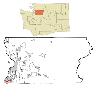
East Hill-Meridian is a former census-designated place (CDP) in King County, Washington. The population was 29,878 at the time of the 2010 census. The majority of the census area is now within the limits of Kent and Renton.

<span class="mw-page-title-main">East Renton Highlands, Washington</span> Census-designated place in Washington, United States

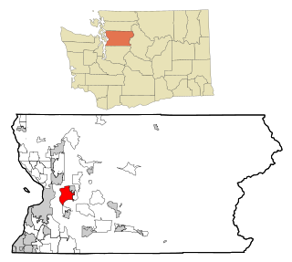
East Renton Highlands is a census-designated place (CDP) in King County, Washington, United States, located between Issaquah and Renton. The population was 11,937 at the 2020 census.

<span class="mw-page-title-main">Inglewood-Finn Hill, Washington</span> Neighborhood in King, Washington, United States

Inglewood-Finn Hill was a census-designated place (CDP) in King County, Washington, United States. The population was 22,707 at the 2010 census. The community was largely annexed into neighboring Kirkland in 2011.

<span class="mw-page-title-main">Lakeland South, Washington</span> Census-designated place in Washington, United States

Lakeland South is a census-designated place (CDP) in King County, Washington, United States. The population was 11,574 at the 2010 census.

<span class="mw-page-title-main">Lea Hill, Auburn, Washington</span> Neighborhood in King, Washington, United States

Lea Hill is a neighborhood located in the city of Auburn, Washington, United States. The community was annexed by Auburn on January 1, 2008, after Auburn and Lea Hill residents approved the annexation.

<span class="mw-page-title-main">White Center, Washington</span> Census-designated place in Washington, United States

White Center is a census-designated place (CDP) in King County, Washington, United States. It lies between West Seattle and Burien. The population was 16,631 at the 2020 census.

<span class="mw-page-title-main">Navy Yard City, Washington</span> Census-designated place in Washington, United States

Navy Yard City is a census-designated place (CDP) in Kitsap County, Washington, United States. The population was 2,477 at the 2010 census.

<span class="mw-page-title-main">Parkwood, Washington</span> CDP in Washington, United States

Parkwood is a census-designated place (CDP) in Kitsap County, Washington, United States. The population was 7,126 at the 2010 census.

<span class="mw-page-title-main">Summit, Washington</span> CDP in Washington, United States

Summit is a census-designated place (CDP) in Pierce County, Washington, United States. The population was 8,270 at the 2020 census.

<span class="mw-page-title-main">Waller, Washington</span> CDP in Washington, United States

Waller is a census-designated place (CDP) in Pierce County, Washington, United States. The population was 8,189 at the 2020 census. The population has seen significant growth in the last decade.

<span class="mw-page-title-main">High Bridge, Washington</span> CDP in Washington, United States

High Bridge is a census-designated place (CDP) in Snohomish County, Washington, United States. The population was 2,994 at the 2010 census. High Bridge includes the Echo Lake community and the former Echo Lake CDP, which was superseded by the larger High Bridge CDP in 2010.

<span class="mw-page-title-main">Esperance, Washington</span> CDP in Washington, United States

Esperance is a census-designated place (CDP) in Snohomish County, Washington, United States. Esperance is an enclave of the city of Edmonds, Washington. The population was 3,601 at the 2010 census.

<span class="mw-page-title-main">Machias, Washington</span> CDP in Washington, United States

Machias is a census-designated place (CDP) in Snohomish County, Washington, United States. The population was 1,178 at the 2010 census.

<span class="mw-page-title-main">Martha Lake, Washington</span> CDP in Washington, United States

Martha Lake is a census-designated place (CDP) in Snohomish County, Washington, United States. The population was 21,129 at the 2020 census. It lies west of Mill Creek and northeast of Lynnwood, near the lake of the same name.

<span class="mw-page-title-main">Lake Stickney, Washington</span> CDP in Washington, United States

Lake Stickney is a census-designated place (CDP) in Snohomish County, Washington, United States. The population was 15,413 at the 2020 census. The CDP was known as Paine Field-Lake Stickney prior to 2010. The new Lake Stickney CDP no longer contains the Paine Field airport.

<span class="mw-page-title-main">Bangor Base, Washington</span> Census-designated place in Washington, United States

Bangor Base is a census-designated place (CDP) in Kitsap County, Washington, within U.S. Naval Base Kitsap on the Kitsap Peninsula. Its population was 6,054 at the 2010 census.

References

  1. 1 2 "U.S. Census website". United States Census Bureau . Retrieved 2008-01-31.
  2. "US Board on Geographic Names". United States Geological Survey. 2007-10-25. Retrieved 2008-01-31.
  3. City Council Accepts Annexation, City of Kirkland, December 16, 2009, retrieved 2010-01-01[ dead link ]
  4. "Results - King County Elections". Archived from the original on 2010-01-08. Retrieved 2009-11-06.
  5. "US Gazetteer files: 2010, 2000, and 1990". United States Census Bureau. 2011-02-12. Retrieved 2011-04-23.
  6. "CENSUS OF POPULATION AND HOUSING (1790-2000)". U.S. Census Bureau . Retrieved 2010-07-30.