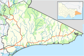
The Western District comprises western regions of the Australian state of Victoria. It is said to be an ill–defined district, sometimes incorrectly referred to as an economic region,. The district is located within parts of the Barwon South West and the Grampians regions; extending from the south-west corner of the state to Ballarat in the east and as far north as Ararat. The district is bounded by the Wimmera district in the north, by the Goldfields district in the east, by Bass Strait and the Southern Ocean in the south, and by the South Australian border in the west. The district is well known for the production of wool. The most populated city in the Western District is the Ballarat region, with 96,940 inhabitants.
The Gunaikurnai or Gunai/Kurnai people, also referred to as the Gunnai or Kurnai, are an Aboriginal Australian nation of south-east Australia. They are the Traditional Custodians of most of present-day Gippsland and much of the southern slopes of the Victorian Alps. The Gunaikurnai nation is composed of five major clans. Many of the Gunaikurnai people resisted early European squatting and subsequent settlement during the nineteenth century, resulting in a number of deadly confrontations between Europeans and the Gunaikurnai. There are about 3,000 Gunaikurnai people alive today, predominantly living in Gippsland. The Gunaikurnai dialects are the traditional language of the Gunaikurnai people, although there are very few fluent speakers today.

Stratford is a town on the Avon River in Victoria, Australia, 232 kilometres (144 mi) east of Melbourne on the Princes Highway in Shire of Wellington. At the 2016 census, Stratford had a population of 2617. The town services the local regional community and travellers on the Princes Highway. Stratford's principal industries are dairying, sheep, cattle and horse breeding and vegetable crops. The town has numerous coffee shops and cafes, a cellar door for a local winery, Design Gallery, model railway shop, a pub, parks and playgrounds for car travelers to break their journey.
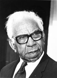
Sir Douglas Ralph Nicholls, was a prominent Aboriginal Australian from the Yorta Yorta people. He was a professional athlete, Churches of Christ pastor and church planter, ceremonial officer and a pioneering campaigner for reconciliation.
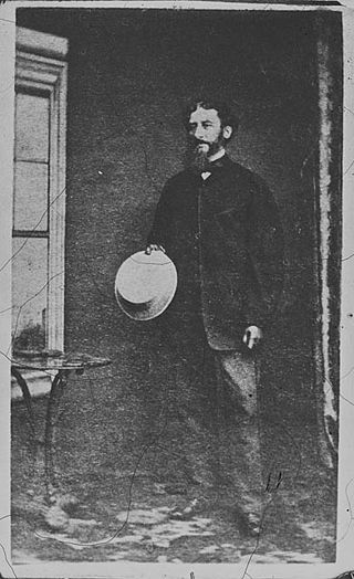
Captain Charles James Tyers RN FRSV was a 19th-century Anglo-Australian surveyor and explorer, and the Commissioner of Crown Lands for Portland (1842–43) and Gippsland (1844–67).
Framlingham is a rural township located by the Hopkins River in the Western District of Victoria, Australia, about 20 kilometres (12 mi) north-east of the coastal city of Warrnambool. In the 2016 census, the township had a population of 158.
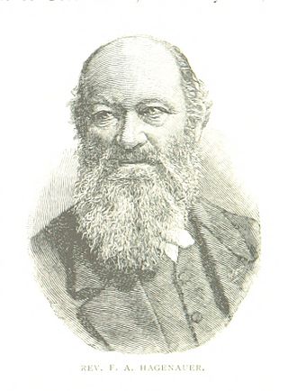
Friedrich Hagenauer (1829–1909) was a Presbyterian minister and missionary in Australia who established Ebenezer Mission and Ramahyuck mission. Reverend Friedrich Hagenauer and Reverend F.W. Spieseke from the German Moravian Church were sent to Australia and established Ebenezer Mission station near Lake Hindmarsh, Victoria, Australia in 1859 in Wergaia territory.
The Gunditjmara or Gunditjamara, also known as Dhauwurd Wurrung, are an Aboriginal Australian people of southwestern Victoria. They are the traditional owners of the areas now encompassing Warrnambool, Port Fairy, Woolsthorpe and Portland. Their land includes much of the Budj Bim heritage areas. The Kerrup Jmara are a clan of the Gunditjmara, whose traditional lands are around Lake Condah. The Koroitgundidj are another clan group, whose lands are around Tower Hill.
The Aboriginal Advancement League was founded in 1957 as the Victorian Aborigines Advancement League (VAAL), is the oldest Aboriginal rights organisation in Australia still in operation. Its precursor organisations were the Australian Aborigines League and Save the Aborigines Committee, and it was also formerly known as Aborigines Advancement League (Victoria), and just Aborigines Advancement League.
Ebenezer Mission, also known as Wimmera mission, Hindmarsh mission and Dimboola mission, was a mission station for Aboriginal people established near Lake Hindmarsh in Victoria, Australia in 1859 by the Moravian Church on the land of the Wotjobaluk. The first missionaries were two Germans, Reverend Friedrich Hagenauer and Reverend F.W. Spieseke. In 1861 the Victorian Colonial Government gazetted 1,897 acres (7.68 km2) as a reserve for the Ebenezer Mission Station. The mission was established a few years after the failure of the Moravian Lake Boga mission in Wemba-Wemba territory.
Dja Dja Wurrung, also known as the Djaara or Jajowrong people and Loddon River tribe, are an Aboriginal Australian people who claim they were the traditional owners of lands including the watersheds of the Loddon and Avoca rivers in the Bendigo region of central Victoria, Australia. They are part of the Kulin alliance of Aboriginal Victorian peoples. There are 16 clans, which adhere to a patrilineal system. Like other Kulin peoples, there are two moieties: Bunjil the eagle and Waa the crow.
The Wergaia or Werrigia people are an Aboriginal Australian group in the Mallee and Wimmera regions of north-Western Victoria, made up of a number of clans. The people were also known as the Maligundidj which means the people belonging to the mali (mallee) eucalypt bushland which covers much of their territory.
Commonwealth, State, and Territory Parliaments of Australia have passed Aboriginal land rights legislation.
An Aboriginal reserve, also called simply reserve, was a government-sanctioned settlement for Aboriginal Australians, created under various state and federal legislation. Along with missions and other institutions, they were used from the 19th century to the 1960s to keep Aboriginal people separate from the white Australian population, for various reasons perceived by the government of the day. The Aboriginal reserve laws gave governments much power over all aspects of Aboriginal people’s lives.

The Buchan River is a perennial river of the Snowy River catchment, located in the Alpine region of the Australian state of Victoria.
Carl Walter, also known as Charles Walter, was an Australian botanist and photographer. He was born in Mecklenburg, Germany in about 1831 and arrived in Victoria in the 1850s.
The Brabiralung are an Indigenous Australian people, one of the five clans of Gippsland, in the state of Victoria, Australia, belonging to a wider regional grouping known as the Kurnai.
Budj Bim heritage areas includes several protected areas in Victoria, Australia, the largest two being Budj Bim National Heritage Landscape and the Budj Bim Cultural Landscape. Within the latter, there are three Indigenous Protected Areas: the Tyrendarra Indigenous Protected Area, Kurtonitj Indigenous Protected Area, and the Lake Condah Indigenous Protected Area.
Lake Condah Mission, also known as Condah Mission, was established in 1867 as a Church of England mission, approximately 3 kilometres (1.9 mi) from Lake Condah, which was traditionally known as Tae Rak, and about 20 kilometres (12 mi) to 25 kilometres (16 mi) south-east of the small town of Condah. The site of the mission, on 2,000 acres (810 ha) north of Darlot Creek, was formally reserved in 1869, and the Mission continued operations until the reserve was finally revoked in 1951, with most of the land handed over to the Soldiers Settlement Scheme to provide land for white veterans of World War II.