List of lakes in Kentucky

Last updated
Kentucky Lake Kentucky Lake (Land Between the Lakes National Recreation Area).jpg
Kentucky Lake
Kincaid Lake Kincaid Lake.jpg
Kincaid Lake
Martins Fork Lake Martins Fork Lake Kentucky.jpg
Martins Fork Lake
Paintsville Lake Paintsville Lake framed.jpg
Paintsville Lake
Shanty Hollow Lake Shanty Hollow Lake Autumn.jpg
Shanty Hollow Lake

The following is a list of lakes and reservoirs in the state of Kentucky in the United States.

Lake A body of relatively still water, in a basin surrounded by land

A lake is an area filled with water, localized in a basin, that is surrounded by land, apart from any river or other outlet that serves to feed or drain the lake. Lakes lie on land and are not part of the ocean, and therefore are distinct from lagoons, and are also larger and deeper than ponds, though there are no official or scientific definitions. Lakes can be contrasted with rivers or streams, which are usually flowing. Most lakes are fed and drained by rivers and streams.

Reservoir A storage space for fluids

A reservoir is, most commonly, an enlarged natural or artificial lake, pond or impoundment created using a dam or lock to store water.

U.S. state constituent political entity of the United States

In the United States, a state is a constituent political entity, of which there are currently 50. Bound together in a political union, each state holds governmental jurisdiction over a separate and defined geographic territory and shares its sovereignty with the federal government. Due to this shared sovereignty, Americans are citizens both of the federal republic and of the state in which they reside. State citizenship and residency are flexible, and no government approval is required to move between states, except for persons restricted by certain types of court orders. Four states use the term commonwealth rather than state in their full official names.

Lake Barkley

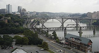
Lake Barkley, a 58,000-acre (230 km2) reservoir in Livingston County, Lyon County and Trigg County in Kentucky and extending into Stewart County and Houston County in Tennessee, was impounded by the U.S. Army Corps of Engineers in 1966 upon the completion of Barkley Dam. Both the lake and the dam are named for Vice President Alben Barkley, a Kentucky native.

Tennessee State of the United States of America

Tennessee is a state located in the southeastern region of the United States. Tennessee is the 36th largest and the 16th most populous of the 50 United States. Tennessee is bordered by Kentucky to the north, Virginia to the northeast, North Carolina to the east, Georgia, Alabama, and Mississippi to the south, Arkansas to the west, and Missouri to the northwest. The Appalachian Mountains dominate the eastern part of the state, and the Mississippi River forms the state's western border. Nashville is the state's capital and largest city, with a 2017 population of 667,560 and a 2017 metro population of 1,903,045. Tennessee's second largest city is Memphis, which had a population of 652,236 in 2017.

Barren River Lake

Barren River Lake is a 10,100 acres (41 km2), reservoir in Kentucky created by the U.S. Army Corps of Engineers in 1964 by impounding the Barren River. The lake occupies parts of Allen, Barren, and Monroe counties.

Related Research Articles

Pickett County, Tennessee County in the United States

Pickett County is a county located in the U.S. state of Tennessee. As of the 2010 census, the population was 5,077, making it the least populous county in Tennessee. Its county seat is Byrdstown.

Tennessee River river in the United States, its largest city is Knoxville, TN

The Tennessee River is the largest tributary of the Ohio River. It is approximately 652 miles (1,049 km) long and is located in the southeastern United States in the Tennessee Valley. The river was once popularly known as the Cherokee River, among other names, as many of the Cherokee had their territory along its banks, especially in eastern Tennessee and northern Alabama. Its current name is derived from the Cherokee village Tanasi.

Cumberland River river in the United States of America

The Cumberland River is a major waterway of the Southern United States. The 688-mile-long (1,107 km) river drains almost 18,000 square miles (47,000 km2) of southern Kentucky and north-central Tennessee. The river flows generally west from a source in the Appalachian Mountains to its confluence with the Ohio River near Paducah, Kentucky, and the mouth of the Tennessee River. Major tributaries include the Obey, Caney Fork, Stones, and Red rivers.

Wolf River (Middle Tennessee) river in United States of America

The Wolf River is a 40.3-mile-long (64.9 km) river in the U.S. states of Tennessee and Kentucky that rises at the base of the Cumberland Plateau in Fentress County, Tennessee and flows westward for several miles before emptying into the Obey River at the Dale Hollow Reservoir. The river is part of the Cumberland River drainage basin, and flows primarily in Middle Tennessee and southern Kentucky. Via the Cumberland and Ohio rivers, it is part of the Mississippi River watershed. It is not to be confused with the Wolf River of West Tennessee which flows into the Mississippi at Memphis.

The Obey River is a 47.8-mile-long (76.9 km) tributary of the Cumberland River in the U.S. state of Tennessee. It joins the Cumberland River near the town of Celina, which is generally considered to be the Cumberland's head of navigation. Via the Cumberland and Ohio rivers, the Obey River is part of the Mississippi River watershed.

Sheltowee Trace Trail

The Sheltowee Trace Trail is a 323-mile (519.82 km) National Recreation Trail that was created in 1979 and stretches from the Burnt Mill Bridge Trail Head in the Big South Fork National River and Recreation Area in Tennessee to northern Rowan County, Kentucky. The trail is named after Daniel Boone, who was given the name Sheltowee when he was adopted as the son of the great warrior Chief Blackfish of the Shawnee tribe.

Dale Hollow Reservoir

The Dale Hollow Reservoir is a reservoir situated on the Kentucky/Tennessee border. The lake is formed by the damming of the Obey River, 7.3 miles (12 km) above its juncture with the Cumberland River at river mile 380. Portions of the lake also cover the Wolf River. Dale Hollow is one of four major flood control reservoirs for the Cumberland; the others being J. Percy Priest Dam, Wolf Creek Dam, and Center Hill Dam. It is also the site of Dale Hollow Lake State Park on the north (Kentucky) side.

Carr Creek Lake

Carr Creek Lake, located east of Hazard, Kentucky, along Kentucky Route 15 in Knott County, is a 710 acres (3 km2) reservoir created by the U.S. Army Corps of Engineers in 1976. Carr Creek Lake's earth and rock fill dam is 130 ft (40 m) tall and 720 ft (219 m) long, and the dam is located 8.8 mi (14 km) above the mouth of Carr Fork River, a tributary of the North Fork Kentucky River.

Big South Fork National River and Recreation Area

The Big South Fork National River and Recreation Area preserves the Big South Fork of the Cumberland River and its tributaries in northeastern Tennessee and southeastern Kentucky. In addition, the former mining community of Blue Heron is preserved and interpreted via signage.

Powell Mountain is a mountain ridge of the Ridge-and-valley Appalachians of the Appalachian Mountains. It is a long and narrow ridge, running northeast to southwest, from about Norton, Virginia to near Tazewell, Tennessee. It separates the Clinch River basin and the Powell River basin of Powell Valley. It was named for an 18th-century explorer.

Cove Lake State Park

Cove Lake State Park is a state park in Campbell County, Tennessee, in the southeastern United States. The park consists of 673 acres (2.72 km2) situated around Cove Lake, an impoundment of Cove Creek created by the completion of Caryville Dam in 1936. The park's location is adjacent to the town of Caryville and just west of Jacksboro.

Indian Mountain State Park

Indian Mountain State Park is a state park in Campbell County, Tennessee, in the southeastern United States. Established in 1971, the park consists of 213 acres (0.86 km2) situated at the base of Indian Mountain, a 1,949-foot (594 m) summit that overlooks the Elk Valley in the Cumberland Mountains. The park is located immediately west of the city of Jellico, and the history and development of the two are intertwined to a great extent.