List of roads in Hamilton, Ontario

Last updated

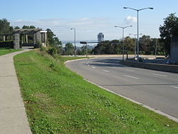
Skyline view from Jolley Cut, mountain access road HamiltonOntarioSkylineB.JPG
Skyline view from Jolley Cut, mountain access road

This is a List of streets in Hamilton, Ontario, many of which were named after the Loyalist families who arrived to Hamilton after the British lost the American Revolutionary War. These names include Hess, Hughson, Herkimer, Land, Beasley, Gage, Doan, Davis, Mills, Carpenter, and Brant. The Loyalists were the pioneers of Hamilton and area. [1]

Contents

Many of the street names in Hamilton have changed over the years. James Street south of King was called Jarvis, Jackson Street was Maiden Lane, John Street was Mountain Street, Main Street east of James was Brougham Street, Hunter Street east of James was called Peel Street, Charlton Avenue West was Anderson Street, Charlton Avenue was Hannah Street, Park Street was Bond Street, Bay Street South was Bowry Street, Cannon Street was known as Henry Street, Barton Street West was Concession and Upper James Street on the mountain was known as Caledonia Road. [1]

Lower City (below Escarpment)

OttawaStreetHamiltonA.JPG
Corktown, Ferguson South, landmark FergusonStreetA.JPG
Corktown, Ferguson South, landmark
GO Transit station, Hunter Street HamiltonGoTransitStation.JPG
GO Transit station, Hunter Street
James Street South, street life JamesStreetSouthHamilton.JPG
James Street South, street life
Locke Street South LockeStreetHamilton.JPG
Locke Street South

Mountain (Escarpment)

ConcessionStreetSign.JPG
Upper James Street / Claremont Access,
original site of West-end Incline Railway Claremont Accces.JPG
Upper James Street / Claremont Access,
original site of West-end Incline Railway

Related Research Articles

<span class="mw-page-title-main">Hamilton Street Railway</span> Public transit agency in Ontario, Canada

The Hamilton Street Railway (HSR) is the public transport agency for Hamilton, Ontario. The name is a legacy of the company's early period, when public transit in Hamilton was primarily served by streetcars. Although streetcars are no longer used in the city today, the HSR operates bus and paratransit services, with a ridership of 21 million passengers a year.

Hamilton East was a federal electoral district in Ontario, Canada. It was represented in the House of Commons of Canada from 1904 to 2004. It consisted of the eastern part of the city of Hamilton, Ontario. It is considered a working class district.

<span class="mw-page-title-main">History of Hamilton, Ontario</span>

Hamilton, from the point at which it was first colonized by settlers, has benefited from its geographical proximity to major land and water transportation routes along the Niagara Peninsula and Lake Ontario. Its strategic importance has created, by Canadian standards, a rich military history which the city preserves.

Hamilton West was a federal electoral district in Ontario, Canada, that was represented in the House of Commons of Canada from 1904 to 2004.

<span class="mw-page-title-main">Transportation in Hamilton, Ontario</span> Transportation infrastructure located in Hamilton, Ontario

Transport in Hamilton, Ontario consists of a variety of modes.

<span class="mw-page-title-main">Geography of Hamilton, Ontario</span>

Hamilton is located on the western end of the Niagara Peninsula and wraps around the westernmost part of the Lake Ontario. Most of the city including the downtown section lies along the south shore. Situated in the geographic centre of the Golden Horseshoe, it lies roughly midway between Toronto and Buffalo. The two major physical features are Hamilton Harbour marking the northern limit of the city and the Niagara Escarpment running through the middle of the city across its entire breadth, bisecting the city into 'upper' and 'lower' parts.

<span class="mw-page-title-main">Timeline of events in Hamilton, Ontario</span>

Below is a timeline of events in Hamilton, Ontario, Canada.

<span class="mw-page-title-main">Hughson Street</span>

Hughson Street is a Lower City collector road in Hamilton, Ontario, Canada. It starts at Charlton Avenue East at St. Joseph's hospital and runs north to Haymarket Street in the downtown where it's cut off by the Hamilton GO Transit station. Up to this point it is a two-way street. It then starts up again north of the station on Hunter Street East, where it then becomes a one-way street going north just past Barton Street East to Murray Street where it's cut off again by a parking lot for LIUNA Station. It then starts up again one block north past the CN railway tracks on Strachan Street and from this point onwards becomes a two-way street again that extends to the city's North End to the waterfront on Guise Street West, the site of the Canada Marine Discovery Centre and Pier 9.

<span class="mw-page-title-main">Locke Street (Hamilton, Ontario)</span> Canadian road

Locke Street is a Lower City collector road in Hamilton, Ontario, Canada. It starts off at Aberdeen Avenue as a two-way street going through the Locke Street shopping district up to Main Street where it then becomes a one-way street until it crosses King Street and becomes two-way again going north past Victoria Park and ends just past Barton Street West on Tecumseh Street, a road that winds West and leads to the back-end of Dundurn Park.

<span class="mw-page-title-main">Dundurn Street (Hamilton, Ontario)</span> Lower City arterial road in Hamilton, Ontario, Canada

Dundurn Street is a Lower City arterial road in Hamilton, Ontario, Canada. It is a two-way street that starts off at Mountain Face Park, Niagara Escarpment in front of the Bruce Trail as a collector road, right behind Hillcrest Avenue and then turns into a four lane thoroughfare from Aberdeen Avenue northward to York Boulevard where it ends in front of Dundurn Park.

<span class="mw-page-title-main">Catharine Street (Hamilton, Ontario)</span>

Catharine Street is a Lower City collector road in Hamilton, Ontario, Canada. It starts off at Charlton Avenue East at Woolverton Park in the Corktown neighbourhood as a one-way street (southbound), tunnels underneath the Hunter Street Railway bridge and stretches up to Barton Street East where it then turns two-way and cutoff by the CN Railway lines that cut through Strachan Street Park one block north past Barton. Catharine Street then resumes again on Strachan Street East, north of the Park again as a two-way road for 3 blocks and interrupted again at Picton Street East, the site of St. Lawrence Elementary School and resumes again north of this property on Macauley Street East, again as a two-way street for another 3 blocks where it's interrupted for a third time at Brock Street, the site of Eastwood Park and Eastwood Arena. Catherine Street resumes again north of Eastwood Park on Guise Street East and ends at the city's North End waterfront, the site of a Royal Canadian Navy base and Pier 9.

<span class="mw-page-title-main">Sherman Avenue (Hamilton, Ontario)</span> Collector road in the lower portion of Hamilton, Ontario, Canada

Sherman Avenue is a collector road in the lower portion of Hamilton, Ontario, Canada. It begins at the Niagara Escarpment just south of Cumberland Avenue and is a one-way street bisecting the industrialized northern neighbourhoods of the city. It ends at Ship Street — the site of Steel Company of Canada (Stelco).

<span class="mw-page-title-main">Gage Avenue (Hamilton, Ontario)</span> Lower City arterial road in Hamilton, Ontario, Canada

Gage Avenue is a Lower City arterial road in Hamilton, Ontario, Canada. It starts off at Lawrence Road at the base of the Niagara Escarpment (mountain) at the south end of Gage Park. It is a two-way arterial road that extends north through the city's North End industrial neighbourhood and ends at Industrial Drive.

<span class="mw-page-title-main">Cannon Street (Hamilton, Ontario)</span> Road in Hamilton, Ontario, Canada

Cannon Street is a Lower City collector road in Hamilton, Ontario, Canada. It starts off at Queen Street North as a one-way street (Westbound) up to Sherman Avenue North where it then switches over to a two-way street the rest of the way Eastward and ends just past Kenilworth Avenue North on Barons Avenue and merges with Britannia Avenue, a street that runs parallel with Cannon Street from Ottawa Street North to Barons Avenue.

<span class="mw-page-title-main">King Street, Hamilton, Ontario</span>

King Street is a Lower City arterial road in Hamilton, Ontario, Canada, also known as Highway 8. The western-end starts off beside McMaster University Medical Centre as a two-way street and passes through Westdale. At Paradise Road, King Street switches over to a one-way street (westbound) right through the city's core up to "the Delta", a spot in town where King and Main streets intersect. From the Delta onwards, King Street then switches over to become a two-way street again and ends at Highway 8 in Stoney Creek.

<span class="mw-page-title-main">Main Street (Hamilton, Ontario)</span>

Main Street is a street in Hamilton, Ontario, Canada.

<span class="mw-page-title-main">Hunter Street (Hamilton, Ontario)</span> Lower City collector road in Hamilton, Ontario, Canada

Hunter Street is a Lower City collector road in Hamilton, Ontario, Canada. It is a one-way street (Westbound) that starts West of Locke Street at Hill Street Park and ends two blocks East of Victoria Avenue at Emerald Street. Hunter Street is a two-way street between Victoria and Emerald Streets.

Beasley is a neighbourhood in the Lower City area of Hamilton, Ontario, Canada. The Beasley neighbourhood is bounded in the north by the Canadian National Railway tracks just north of Barton Street, James Street (west), Main Street (south) and Wellington Street (east).

<span class="mw-page-title-main">Concession Street (Hamilton, Ontario)</span> Road in Hamilton, Ontario, Canada

Concession Street is an Upper City (mountain) arterial road in Hamilton, Ontario, Canada. It starts at Belvidere Avenue, just west of Sam Lawrence Park, and extends eastward past Mountain Drive Park on Upper Gage Avenue and ends shortly thereafter at East 43rd Street.

<span class="mw-page-title-main">Upper James Street (Hamilton, Ontario)</span> Upper City (mountain) arterial road in Hamilton, Ontario, Canada

Upper James Street, is an Upper City (mountain) arterial road in Hamilton, Ontario, Canada. It starts at the Claremont Access, a mountain-access road in the north, and extends southward towards the John C. Munro Hamilton International Airport where it then changes its name to the Hamilton Port Dover Plank Road,. It is a two-way street throughout. As with most of the "Upper" streets, their addresses start at roughly the point where their lower counterpart finishes just below the Escarpment and were originally labelled without the "Upper" prefix.

References

  1. 1 2 Watson, Milton (1938). Saga of a City. The Hamilton Spectator.
  2. 1 2 3 4 5 6 7 8 9 10 11 12 13 14 15 16 17 18 19 Houghton, Margaret (2002). Hamilton Street Names: An Illustrated Guide. James Lorimer & Co. Ltd. ISBN   1-55028-773-7.
  3. 1 2 3 4 5 6 7 8 9 10 11 Manson, Bill (2003). Footsteps In Time: Exploring Hamilton's heritage neighbourhoods. North Shore Publishing Inc. ISBN   1-896899-22-6.
  4. 1 2 3 4 5 6 7 8 9 10 11 12 Bailey, Thomas Melville (1981). Dictionary of Hamilton Biography (Vol I, 1791–1875). W.L. Griffin Ltd.
  5. "Sir Allan MacNab & Dundurn". www.hamiltonhistory.ca. Retrieved 2020-08-21.
  6. MacLennan, Malcolm (1979). Gaelic Dictionary/Faclair Gàidhlig. Edinburgh, Scotland: Acair and Mercat Press. pp. 132, 139. ISBN   1873644116.
  7. "Heritage". www.stfillanscc.org.uk. Retrieved 2020-08-21.
  8. Bailey, Melville (1987). The History of Dundurn Castle and Sir Allan MacNab (reprint ed.). pp. 1–38.
  9. "Hamilton Spectator: "The Greatest Hamiltonian". (II)". Archived from the original on 2007-09-27. Retrieved 2008-01-25.
  10. "The Hamilton Gallery of Distinction". Archived from the original on 2006-05-11. Retrieved 2008-01-25.
  11. Burkholder, Mabel (1956). Barton on the Mountain. Hamilton Public Library.
  12. Bailey, Thomas Melville (1992). Dictionary of Hamilton Biography (Vol III, 1925–1939). W.L. Griffin Ltd.