
Mundubbera is a rural town and a locality in the North Burnett Region, Queensland, Australia. In the 2021 census, the locality of Mundubbera had a population of 1,120 people.

Kingaroy is a rural town and locality in the South Burnett Region, Queensland, Australia. The town is situated on the junction of the D'Aguilar and the Bunya Highways, 218 kilometres (135 mi) north-west of the state capital Brisbane and 141 kilometres (88 mi) south west of Gympie. In the 2021 census, the locality of Kingaroy had a population of 10,266 people.

The Burnett Highway is an inland rural highway located in Queensland, Australia. The highway runs from its junction with the Bruce Highway at Gracemere, just south of Rockhampton, to the D'Aguilar Highway in Nanango. Its length is approximately 542 kilometres. The highway takes its name from the Burnett River, which it crosses in Gayndah. The Burnett Highway provides the most direct link between the northern end of the New England Highway and Rockhampton. It is designated as a State Strategic Road by the Queensland Government.

Murgon is a rural town and locality in the South Burnett Region, Queensland, Australia. In the 2021 census, the locality of Murgon had a population of 2,220 people.

Kilkivan is a town and locality in the Gympie Region of Queensland, Australia. In the 2021 census, the locality of Kilkivan had a population of 689 people.

Goomeri is a rural town and locality in the Gympie Region, Queensland, Australia. In the 2021 census, the locality of Goomeri had a population of 677 people.

The Shire of Murgon was a local government area in the South Burnett region of Queensland, Australia. The shire covered an area of 664.7 square kilometres (256.6 sq mi), and existed as a local government entity from 1914 until 2008, when it amalgamated with several other councils in the South Burnett area to become the South Burnett Regional Council.
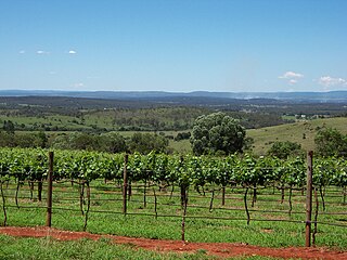
The South Burnett is a peanut growing and wine-producing area on the Great Dividing Range, north of the Darling Downs, in Queensland. It is with the basin of the Burnett River. The area is within two local government areas, South Burnett Region and Gympie Region.

Tingoora is a rural town and a locality in the South Burnett Region, Queensland, Australia.

Dickabram Bridge is a heritage-listed road-and-rail bridge over the Mary River between Miva and Theebine, both in the Gympie Region, Queensland, Australia. It was the major bridge on the Kingaroy railway line. It was designed by Henry Charles Stanley and built from 1885 to 1886 by Messrs Michael McDermott, Owens & Co. It is also known as Mary River Bridge (Miva). The bridge was registered on the former Register of the National Estate in 1988.
Theebine railway station is a closed railway station on the North Coast railway line of Queensland, Australia at Theebine. Slightly south of the railway station is the junction between the main North Coast line and the Kingaroy branch, which continues into west Queensland. It is also the junction for the Dickabram line.

Theebine is a rural town and locality split between the Gympie Region and the Fraser Coast Region, both in Queensland, Australia.

The Nanango railway line was a narrow-gauge branch railway located in Queensland, Australia. On 31 October 1882, parliament approved the construction of a branch line from Theebine west to Kilkivan after gold and copper were discovered in this region of Queensland, Australia. The section was opened in two stages – to Dickabram on 1 January 1886 after two crossings of the Mary River and to Kilkivan on 6 December 1886.

Wide Bay–Burnett is a region of the Australian state of Queensland, located between 170–400 km (110–250 mi) north of the state capital, Brisbane. The area's population growth has exceeded the state average over the past 20 years, and it is forecast to grow to more than 430,000 by 2031. It is the subject of the Draft Wide Bay–Burnett Regional Plan, which aims to facilitate this growth while protecting over 90% of the region from urban development.
The Kilkivan to Kingaroy Rail Trail is an 88-kilometre (55 mi) recreation trail from Kilkivan to Kingaroy. The trail follows the old Kingaroy Branch railway and is open to walkers, cyclists and horse riders.

St Michael and All Angels Church is a heritage-listed Anglican church at 2-6 Alford Street, Kingaroy, South Burnett Region, Queensland, Australia. It was designed by Colin Deighton and built in 1911. It was added to the Queensland Heritage Register on 17 September 2010.

Murgon Civic Centre is a heritage-listed town hall at 62–70 Lamb Street, Murgon, South Burnett Region, Queensland, Australia. It is also known as Murgon Public Hall. It was designed by Clifford Ernest Plant and built in 1938 by HG Neilsen. It was added to the Queensland Heritage Register on 9 November 2012.

South Burnett Co-operative Dairy Association Factory is a heritage-listed former factory at Macalister Street, Murgon, South Burnett Region, Queensland, Australia. It was designed by George Gerald Hutton and built in 1929 by H Taylor. It was added to the Queensland Heritage Register on 9 November 2012.

Cinnabar is a rural locality in the Gympie Region, Queensland, Australia. In the 2021 census, Cinnabar had a population of 83 people.

Kinbombi is a rural town and locality in the Gympie Region, Queensland, Australia. In the 2021 census, the locality of Kinbombi had a population of 34 people.
