Musi River Sungai Musi, Air Musi, Musi River, Palembang River, Sungai Palembang, Air Moesi, Kali Musi | |
---|---|
Location | |
Country | South Sumatra, Indonesia |
Physical characteristics | |
Source | |
• location | Barisan Mountains, Kepahiang, Bengkulu |
• coordinates | 3°24′21.528″S102°35′53.1204″E / 3.40598000°S 102.598089000°E |
• elevation | 1,300 m (4,300 ft) |
Mouth | |
• location | Bangka Strait, South China Sea, South Sumatra |
• coordinates | 2°19′51.7224″S104°55′19.9668″E / 2.331034000°S 104.922213000°E |
• elevation | 0 m (0 ft) |
Length | 759 km (472 mi) [1] |
Basin size | 56,931 km2 (21,981 sq mi) [2] 59,942 km2 (23,144 sq mi) [3] |
Width | |
• minimum | 250 m (820 ft) (Palembang) [4] |
• average | 540 m (1,770 ft) (Palembang) [4] |
• maximum | 1,350 m (4,430 ft) (Palembang) [4] |
Depth | |
• average | 8 m (26 ft)(Palembang) [5] |
Discharge | |
• location | Musi Delta, Bangka Strait |
• average | (Period: 1992–2016)3,054 m3/s (107,900 cu ft/s) [2] (Period: 2016–2020)3,066 m3/s (108,300 cu ft/s) [6] (Period: 1971–2000)3,211.2 m3/s (113,400 cu ft/s) [1] (Period: 2009–2013)3,961Contentsm3/s (139,900 cu ft/s) [7] |
Discharge | |
• location | Palembang, (Confluence of Komering, 78 km upstream of mouth; Basin size: 53,500 km2 (20,700 sq mi) |
• average | (Period: 1971–2000)2,953.7 m3/s (104,310 cu ft/s) [1] 2,700 m3/s (95,000 cu ft/s) |
• minimum | 1,400 m3/s (49,000 cu ft/s) [3] |
• maximum | 4,200 m3/s (150,000 cu ft/s) [3] |
Discharge | |
• location | Sekayu (Basin size: 21,146.3 km2 (8,164.6 sq mi)) |
• average | (Period: 1971–2000)1,205.4 m3/s (42,570 cu ft/s) [1] |
Discharge | |
• location | Tebing Tinggi (Basin size: 3,329.7 km2 (1,285.6 sq mi) |
• average | (Period: 1971–2000)183.6 m3/s (6,480 cu ft/s) [1] |
Basin features | |
Progression | South China Sea |
River system | Musi River |
Tributaries | |
• left | Kungku, Klingi, Lakitan, Rawas, Harileko, Sebalik |
• right | Keru, Nibung, Lintang, Kikim, Semangus, Keruh, Langgaran, Medak, Simpang, Dua, Penukal, Lematang, Belida, Kramasan, Ogan, Komering |
The Musi River (Indonesian : Sungai Musi) is a river in Southern Sumatra, Indonesia. [8] It flows from south-west to north-east, from the Barisan Mountains range that form the backbone of Sumatra, in Kepahiang Regency, Bengkulu Province, to the Bangka Strait that forms an extension of the South China Sea. The Musi is about 750 kilometers long, and drains most of South Sumatra province. After flowing through Palembang, the provincial capital, it joins with several other rivers, including the Banyuasin River, to form a delta near the town of Sungsang. The river, dredged to a depth of about 8 meters, [5] is navigable by large ships as far as Palembang, which is the site of major port facilities used primarily for the export of petroleum, rubber and palm oil.
This river system, especially around the city of Palembang, was the heart of eponymous 7th to 13th century Srivijayan empire. The river mouth was the site of the SilkAir Flight 185 plane crash which killed all 104 passengers and crew on board in 1997. [9]
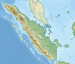
The river flows in the southern area of Sumatra, which has a predominantly tropical rainforest climate (designated as Af in the Köppen-Geiger climate classification). [10] The annual average temperature in the area is 24 °C. The warmest month is July, when the average temperature is around 26 °C, and the coldest is February, at 22 °C. [11] The average annual rainfall is 2579 mm. The wettest month is April, with an average of 344 mm rainfall, and the driest is September, with 99 mm of rain. [12]
The main tributaries from the mouth: [1]
Left tributary | Right tributary | Length (km) | Basin size (km2) | Average discharge (m3/s) |
---|---|---|---|---|
Musi | 759 | 59,942 | 3,211.2 | |
Sebalik | 282.6 | 14.6 | ||
Komering | 328 | 9,908 | 458.7 | |
Ogan | 313 | 8,233 | 432.9 | |
Kramasan | 241.6 | 11.6 | ||
Belida | 462.7 | 23.1 | ||
Lematang | 348 | 7,340 | 396.1 | |
Penukal | 959.5 | 52.8 | ||
Harileko | 334 | 3,746 | 186.7 | |
Dua | 317 | 17.5 | ||
Simpang | 368 | 20.7 | ||
Medak | 72 | 395.3 | 25.7 | |
Langgaran | 226 | 12.8 | ||
Keruh | 554.2 | 31.9 | ||
Rawas | 208 | 5,841 | 333.9 | |
Lakitan | 140 | 2,763 | 161.2 | |
Semangus | 183 | 1,933 | 125.3 | |
Kelingi | 98 | 1,898 | 126.9 | |
Kungku | 667.1 | 38.6 | ||
Kikim | 1,524.1 | 86.8 | ||
Lintang | 572 | 31.9 | ||
Keru | 315.3 | 18.1 |
The Batang Hari is the longest river in Sumatra island, Indonesia, about 600 kilometres (370 mi) northwest of the capital Jakarta.
The Indragiri River is a river in Sumatra, in the Indonesian province of Riau, about 800 km northwest of the capital Jakarta. Formed by the union of the Ombilin River and the Sinamar River, the Indragiri empties into the Strait of Malacca. The middle part that flows in the Kuantan Singingi Regency is called Batang Kuantan.
The Bohorok River is a river of the Langkat Regency in North Sumatra province, Indonesia, about 1,400 km northwest of the capital Jakarta. It is a tributary of Wampu River.
The Siak is a river of Riau province, in the east of Sumatra, Indonesia, about 1000 km northwest of the capital Jakarta. Approximately 370 kilometres in length, the Siak is a blackwater river which owes its brown color to dissolved organic matter (DOM) leached from surrounding, heavily disturbed peat soils; it is heavily polluted, notably by the petroleum industry. It flows through the town of Pekanbaru before emptying into the Strait of Malacca.
The Sembakung River is a river in Borneo that flows from Sabah, Malaysia to North Kalimantan, Indonesia, about 1600 km northeast of the capital Jakarta.
Simpang-kiri River is a river in Riau province, central-eastern Sumatra, Indonesia, about 800 km northwest of the capital Jakarta.
Simpang-kanan River is a river in northern Sumatra, Indonesia, about 1400 km northwest of the capital Jakarta.
Kualuh River is a river in northern Sumatra, Indonesia, about 1600 km northwest of the capital Jakarta.
The Banyuasin River is a river in southern Sumatra, Indonesia, about 500 km northwest of the capital Jakarta.
The Bila River is a river in northern Sumatra, Indonesia, about 1,200 km northwest of the capital Jakarta. It is a tributary of the Barumun River.
The Komering River is a river in South Sumatra, Indonesia. It is a tributary of the Musi River.
The Ogan River is a river in South Sumatra, Indonesia. It is a tributary of the Musi River in Southern Sumatra. Flowing entirely in the South Sumatra province, it rises in Barisan Mountains and meanders slowly eastwards to join the Musi at Kertapati, Palembang. The Ogan ranks as the third longest river in South Sumatra. The river either borders or flows through the regencies of South OKU, OKU, OKI, and Ogan Ilir.
Rokan-kiri River is a river in Riau province, central part of Sumatra island, Indonesia, about 1,100 km northwest of the capital Jakarta. It is a tributary of the Rokan River.
Rokan-kanan River is a river in Riau province, in central part of Sumatra island, Indonesia, about 1,100 km northwest of the capital Jakarta. It is a tributary of the Rokan River.
Kumu River is a river in Riau province, central-eastern Sumatra, Indonesia, about 1,100 km northwest of the capital Jakarta. It is a tributary of the Rokan River.
The Kampar Kanan River is a river in Riau province, Sumatra island, Indonesia. It is a tributary of the Kampar River.
The Kampar River is on the island of Sumatra in Indonesia, about 800 km northwest of the capital Jakarta. It is a well-known river surfing destination because of its tidal bore, known as Bono.
Rokan River is a river in Riau province, central-eastern Sumatra, Indonesia, about 1,100 km northwest of the capital Jakarta.
The Kampar Kiri River is a river in central Sumatra, Indonesia, about 900 km northwest of the capital Jakarta. It is a tributary of the Kampar River.
The Simpang-kanan River is a river in southern Sumatra, Indonesia, about 600 km northwest of the capital Jakarta. It is a tributary of the Rawas River.