The following is a list of Registered Historic Places in Bay County, Michigan.
This National Park Service list is complete through NPS recent listings posted March 4, 2022. [1]
Contents
| [2] | Name on the Register [3] | Image | Date listed [4] | Location | City or town | Description |
|---|---|---|---|---|---|---|
| 1 | Bay City Downtown Historic District |  | September 12, 1985 (#85002338) | Roughly bounded by Saginaw River, Second and Adam Sts. and Center Ave. 43°36′00″N83°53′18″W / 43.6°N 83.888333°W | Bay City | |
| 2 | Bay City Masonic Temple |  | May 3, 2016 (#16000216) | 700 N. Madison Ave. 43°35′49″N83°53′04″W / 43.596956°N 83.884408°W | Bay City | |
| 3 | Bay County Building |  | March 25, 1982 (#82002825) | 515 Center Ave. 43°35′54″N83°53′06″W / 43.598333°N 83.885°W | Bay City | |
| 4 | Center Avenue Neighborhood Residential District |  | April 22, 1982 (#82002826) | Roughly bounded by N. Madison, Green, & Center Aves., 4th, 5th, 6th, & 10th Sts., Carroll Rd. & Nurmi Dr. 43°35′48″N83°52′14″W / 43.596667°N 83.870556°W | Bay City | The original 1982 district was roughly bounded by Green and N. Madison Aves, 5th and 6th Sts. The boundaries were increased on December 12, 2012 (refnum 12001027) to those noted, which encompass the original boundaries. |
| 5 | City Hall | 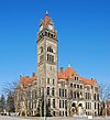 | July 18, 1975 (#75000936) | 301 Washington St. 43°35′36″N83°53′21″W / 43.593333°N 83.889167°W | Bay City | |
| 6 | James Clements Airport Administration Building |  | November 22, 1982 (#82000494) | 614 S. River Rd. 43°32′52″N83°53′31″W / 43.547778°N 83.891944°W | Bay City | |
| 7 | USS Edson (DD-946) |  | June 21, 1990 (#90000333) | Saginaw River 43°36′50″N83°52′10″W / 43.613953°N 83.869405°W | Bay City | |
| 8 | Elm Lawn Cemetery |  | May 18, 2006 (#06000404) | 300 Ridge Rd. 43°35′19″N83°51′29″W / 43.588611°N 83.858056°W | Bay City | |
| 9 | Fletcher Site |  | April 16, 1971 (#71001018) | Btw Marquette Ave. and the Saginaw River [5] 43°36′30″N83°53′30″W / 43.608333°N 83.891667°W | Bay City | |
| 10 | Mercy Hospital and Elizabeth McDowell Bialy Memorial House |  | April 22, 1980 (#80001848) | 15th and Water Sts. 43°35′11″N83°53′34″W / 43.586389°N 83.892778°W | Bay City | |
| 11 | Midland Street Commercial District |  | April 22, 1982 (#82002827) | Roughly bounded by John, Vermont, Catherine and Litchfield Sts. 43°36′06″N83°53′57″W / 43.601667°N 83.899167°W | Bay City | |
| 12 | Odd Fellows Valley Lodge No. 189 Building | 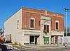 | July 19, 2010 (#10000474) | 1900 Broadway Ave. 43°34′11″N83°53′38″W / 43.569722°N 83.893889°W | Bay City | |
| 13 | Pere Marquette Railroad Depot, Bay City Station | 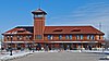 | April 15, 1982 (#82002828) | 919 Boutell Pl. 43°36′00″N83°53′06″W / 43.6°N 83.885°W | Bay City | |
| 14 | Sage Library | 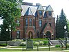 | December 31, 1979 (#79001149) | 100 E. Midland St. 43°36′06″N83°54′17″W / 43.601667°N 83.904722°W | Bay City | |
| 15 | Saginaw River Light Station |  | July 19, 1984 (#84001373) | Coast Guard St. 43°38′08″N83°51′01″W / 43.635556°N 83.850278°W | Bay City | |
| 16 | Tromble House | 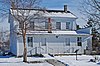 | January 25, 1973 (#73000943) | Veterans Memorial Park 43°35′28″N83°53′59″W / 43.591111°N 83.899722°W | Bay City |


