National Register of Historic Places listings in Goshen County, Wyoming

Last updated

Location of Goshen County in Wyoming Map of Wyoming highlighting Goshen County.svg
Location of Goshen County in Wyoming

This is a list of the National Register of Historic Places listings in Goshen County, Wyoming. It is intended to be a complete list of the properties and districts on the National Register of Historic Places in Goshen County, Wyoming, United States. The locations of National Register properties and districts for which the latitude and longitude coordinates are included below, may be seen in a map. [1]

Contents

There are 7 properties and districts listed on the National Register in the county.


    This National Park Service list is complete through NPS recent listings posted May 26, 2023. [2]

Map all coordinates using: OpenStreetMap  
Download coordinates as: KML
Contents: Counties in Wyoming
Albany - Big Horn - Campbell - Carbon - Converse - Crook - Fremont - Goshen - Hot Springs - Johnson - Laramie - Lincoln - Natrona - Niobrara - Park - Platte - Sheridan - Sublette - Sweetwater - Teton - Uinta - Washakie - Weston

Current listings

[3] Name on the RegisterImageDate listed [4] Location City or townDescription
1 Cheyenne-Black Hills Stage Route and Rawhide Buttes and Running Water Stage Stations
Cheyenne-Black Hills Stage Route and Rawhide Buttes and Running Water Stage Stations CheyenneBlackHillsTrailByPhilKonstantin.jpg
Cheyenne-Black Hills Stage Route and Rawhide Buttes and Running Water Stage Stations
April 16, 1969
(#69000190)
1 mi (1.6 km) west to about 15 mi (24 km) southwest of Lusk
42°46′12″N104°28′30″W / 42.77°N 104.475°W / 42.77; -104.475 (Cheyenne-Black Hills Stage Route and Rawhide Buttes and Running Water Stage Stations)
Lusk
2 Fort Laramie National Historic Site
Fort Laramie National Historic Site DSCN5227 fortlaramiegrounds e.jpg
Fort Laramie National Historic Site
October 15, 1966
(#66000755)
3 mi (4.8 km) southwest of Fort Laramie
42°12′20″N104°33′02″W / 42.205556°N 104.550556°W / 42.205556; -104.550556 (Fort Laramie National Historic Site)
Fort Laramie
3 Fort Laramie Three-Mile Hog Ranch April 23, 1975
(#75001901)
5.5 mi (8.9 km) west of Fort Laramie along the Laramie River
42°11′49″N104°37′20″W / 42.196944°N 104.622222°W / 42.196944; -104.622222 (Fort Laramie Three-Mile Hog Ranch)
Fort Laramie
4 Hell Gap Paleoindian Site (48GO305) December 23, 2016
(#100000877)
Address restricted [5]
42°24′30″N104°38′22″W / 42.408333°N 104.63944°W / 42.408333; -104.63944 (Hell Gap Paleoindian Site (48GO305))
Guernsey
5 Jay Em Historic District
Jay Em Historic District Jay Em, Wyoming.JPG
Jay Em Historic District
April 12, 1984
(#84003665)
Main St.
42°27′40″N104°22′11″W / 42.461111°N 104.369722°W / 42.461111; -104.369722 (Jay Em Historic District)
Jay Em
6 South Torrington Union Pacific Depot
South Torrington Union Pacific Depot South Torrington Union Pacific Depot from NW 1.JPG
South Torrington Union Pacific Depot
December 31, 1974
(#74002025)
U.S. Route 85
42°02′53″N104°11′01″W / 42.048056°N 104.183694°W / 42.048056; -104.183694 (South Torrington Union Pacific Depot)
Torrington
7 US Post Office-Torrington Main
US Post Office-Torrington Main Torrington, Wyoming post office from NW 1.JPG
US Post Office-Torrington Main
May 19, 1987
(#87000783)
2145 Main St.
42°03′57″N104°11′03″W / 42.06586°N 104.18403°W / 42.06586; -104.18403 (US Post Office-Torrington Main)
Torrington

See also

Related Research Articles

<span class="mw-page-title-main">National Register of Historic Places listings in Clallam County, Washington</span>

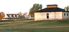
This is a list of the National Register of Historic Places listings in Clallam County, Washington.

<span class="mw-page-title-main">National Register of Historic Places listings in Chelan County, Washington</span>

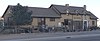
This is a list of the National Register of Historic Places listings in Chelan County, Washington.

<span class="mw-page-title-main">National Register of Historic Places listings in Big Horn County, Wyoming</span>

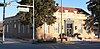
This is a list of the National Register of Historic Places listings in Big Horn County, Wyoming.

<span class="mw-page-title-main">National Register of Historic Places listings in Johnson County, Wyoming</span> National Register of Historic Places listings in Johnson

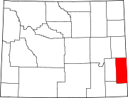
This is a list of the National Register of Historic Places listings in Johnson County, Wyoming. It is intended to be a complete list of the properties and districts on the National Register of Historic Places in Johnson County, Wyoming, United States. The locations of National Register properties and districts for which the latitude and longitude coordinates are included below, may be seen in an online map.

<span class="mw-page-title-main">National Register of Historic Places listings in Sarpy County, Nebraska</span>

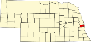
This is a list of the National Register of Historic Places listings in Sarpy County, Nebraska.

<span class="mw-page-title-main">National Register of Historic Places listings in Clearwater County, Idaho</span>

This is a list of the National Register of Historic Places listings in Clearwater County, Idaho.

<span class="mw-page-title-main">National Register of Historic Places listings in Carbon County, Montana</span>

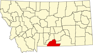
This is a list of the National Register of Historic Places listings in Carbon County, Montana.

<span class="mw-page-title-main">National Register of Historic Places listings in Gallatin County, Montana</span>

This is a list of the National Register of Historic Places listings in Gallatin County, Montana.

<span class="mw-page-title-main">National Register of Historic Places listings in Lewis and Clark County, Montana</span>

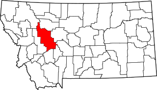
This is a list of the National Register of Historic Places listings in Lewis and Clark County, Montana.

<span class="mw-page-title-main">National Register of Historic Places listings in Chouteau County, Montana</span>

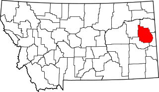
This is a list of the National Register of Historic Places listings in Chouteau County, Montana. It is intended to be a complete list of the properties and districts on the National Register of Historic Places in Chouteau County, Montana, United States. The locations of National Register properties and districts for which the latitude and longitude coordinates are included below, may be seen in a map.

<span class="mw-page-title-main">National Register of Historic Places listings in Dawson County, Montana</span>

This is a list of the National Register of Historic Places listings in Dawson County, Montana. It is intended to be a complete list of the properties and districts on the National Register of Historic Places in Dawson County, Montana, United States. The locations of National Register properties and districts for which the latitude and longitude coordinates are included below, may be seen in a map.

<span class="mw-page-title-main">National Register of Historic Places listings in Edgecombe County, North Carolina</span>

This list includes properties and districts listed on the National Register of Historic Places in Edgecombe County, North Carolina, United States. Click the "Map of all coordinates" link to the right to view a Google map of all properties and districts with latitude and longitude coordinates in the table below.

<span class="mw-page-title-main">National Register of Historic Places listings in Pitt County, North Carolina</span>

This list includes properties and districts listed on the National Register of Historic Places in Pitt County, North Carolina. Click the "Map of all coordinates" link to the right to view an online map of all properties and districts with latitude and longitude coordinates in the table below.

<span class="mw-page-title-main">National Register of Historic Places listings in Dare County, North Carolina</span>

This list includes properties and districts listed on the National Register of Historic Places in Dare County, North Carolina. Click the "Map of all coordinates" link to the right to view a Google map of all properties and districts with latitude and longitude coordinates in the table below.

<span class="mw-page-title-main">National Register of Historic Places listings in Jefferson County, Missouri</span>

This is a list of the National Register of Historic Places listings in Jefferson County, Missouri.

<span class="mw-page-title-main">National Register of Historic Places listings in Lake County, Montana</span>

This is a list of the National Register of Historic Places listings in Lake County, Montana. It is intended to be a complete list of the properties and districts on the National Register of Historic Places in Lake County, Montana, United States. The locations of National Register properties and districts for which the latitude and longitude coordinates are included below, may be seen in a map.

<span class="mw-page-title-main">National Register of Historic Places listings in Blaine County, Montana</span>

This is a list of the National Register of Historic Places listings in Blaine County, Montana. It is intended to be a complete list of the properties and districts on the National Register of Historic Places in Blaine County, Montana, United States. The locations of National Register properties and districts for which the latitude and longitude coordinates are included below, may be seen in a map.

<span class="mw-page-title-main">National Register of Historic Places listings in Jefferson County, Montana</span>

This is a list of the National Register of Historic Places listings in Jefferson County, Montana. It is intended to be a complete list of the properties and districts on the National Register of Historic Places in Jefferson County, Montana, United States. The locations of National Register properties and districts for which the latitude and longitude coordinates are included below, may be seen in a map.

<span class="mw-page-title-main">National Register of Historic Places listings in Armstrong County, Texas</span>

This is a list of the National Register of Historic Places listings in Armstrong County, Texas.

<span class="mw-page-title-main">National Register of Historic Places listings in Kenedy County, Texas</span>

This is a list of the National Register of Historic Places listings in Kenedy County, Texas.

References

  1. The latitude and longitude information provided in this table was derived originally from the National Register Information System, which has been found to be fairly accurate for about 99% of listings. Some locations in this table may have been corrected to current GPS standards.
  2. National Park Service, United States Department of the Interior, "National Register of Historic Places: Weekly List Actions", retrieved May 26, 2023.
  3. Numbers represent an alphabetical ordering by significant words. Various colorings, defined here, differentiate National Historic Landmarks and historic districts from other NRHP buildings, structures, sites or objects.
  4. The eight-digit number below each date is the number assigned to each location in the National Register Information System database, which can be viewed by clicking the number.
  5. Federal and state laws and practices restrict general public access to information regarding the specific location of this resource. In some cases, this is to protect archeological sites from vandalism, while in other cases it is restricted at the request of the owner. See: Knoerl, John; Miller, Diane; Shrimpton, Rebecca H. (1990), Guidelines for Restricting Information about Historic and Prehistoric Resources, National Register Bulletin, National Park Service, U.S. Department of the Interior, OCLC   20706997 .