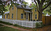
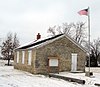
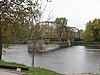
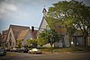
[3] Name on the Register [4] Image Date listed [5] Location City or town Description 1 Ned Ashton House Ned Ashton House January 26, 2001 (# 00001677 820 Park Rd. 41°40′20″N 91°33′03″W / 41.672222°N 91.550833°W / 41.672222; -91.550833 (Ned Ashton House ) Iowa City 2 Charles Berryhill House Charles Berryhill House May 31, 1979 (# 79000904 414 Brown St. 41°40′13″N 91°31′46″W / 41.670278°N 91.529444°W / 41.670278; -91.529444 (Charles Berryhill House ) Iowa City 3 Bethel AME Church Bethel AME Church September 27, 2000 (# 00000925 411 S. Governor St. 41°39′22″N 91°31′23″W / 41.656111°N 91.523056°W / 41.656111; -91.523056 (Bethel AME Church ) Iowa City 4 Billingsley-Hills House Billingsley-Hills House January 21, 1983 (# 83000376 629 Melrose Ave. 41°39′23″N 91°32′54″W / 41.656389°N 91.548333°W / 41.656389; -91.548333 (Billingsley-Hills House ) Iowa City 5 Boerner-Fry Company/Davis Hotel Boerner-Fry Company/Davis Hotel January 27, 1983 (# 83000377 332 E. Washington St. 41°39′37″N 91°31′49″W / 41.660278°N 91.530278°W / 41.660278; -91.530278 (Boerner-Fry Company/Davis Hotel ) Iowa City 6 Albert J. and Alice E. Borts House Upload image May 8, 2019 (# 100003921 416 Reno St. 41°39′59″N 91°31′07″W / 41.6663°N 91.5187°W / 41.6663; -91.5187 (Albert J. and Alice E. Borts House ) Iowa City 7 William Bostick House William Bostick House March 28, 1996 (# 96000312 115 N. Gilbert St. 41°39′45″N 91°31′50″W / 41.6625°N 91.530556°W / 41.6625; -91.530556 (William Bostick House ) Iowa City 8 Bowery Street Grocery Store Bowery Street Grocery Store April 7, 2014 (# 14000112 518 E. Bowery St. 41°39′15″N 91°31′41″W / 41.6542°N 91.5281°W / 41.6542; -91.5281 (Bowery Street Grocery Store ) Iowa City 9 Brown Street Historic District Brown Street Historic District September 23, 1994 (# 94001112 Roughly Brown St. from west of Linn St. to Governor St. and adjacent parts of intersecting streetsSeptember 29, 2004 , refnum 04001096): the 500-800 blocks of E. Ronalds St. 41°40′15″N 91°31′42″W / 41.670833°N 91.528333°W / 41.670833; -91.528333 (Brown Street Historic District ) Iowa City part of the Iowa City Multiple Property Submission (MPS) 10 Buresh Farm Upload image April 29, 1977 (# 77000533 West of Solon off Iowa Highway 382 41°48′35″N 91°33′46″W / 41.809722°N 91.562778°W / 41.809722; -91.562778 (Buresh Farm ) Solon 11 Dr. Albert Henry Byfield House Dr. Albert Henry Byfield House March 23, 2017 (# 100000792 715 W. Park Rd. 41°40′16″N 91°32′56″W / 41.670977°N 91.548905°W / 41.670977; -91.548905 (Dr. Albert Henry Byfield House ) Iowa City 12 Wilbur D. and Hattie Cannon House Wilbur D. and Hattie Cannon House October 7, 1994 (# 94001198 320 Melrose Ave. 41°39′23″N 91°32′42″W / 41.656389°N 91.545°W / 41.656389; -91.545 (Wilbur D. and Hattie Cannon House ) Iowa City 13 Thomas C. Carson House Thomas C. Carson House September 9, 1982 (# 82002623 906 E. College St. 41°39′33″N 91°31′21″W / 41.659167°N 91.5225°W / 41.659167; -91.5225 (Thomas C. Carson House ) Iowa City 14 Cavanaugh-Zetek House Cavanaugh-Zetek House September 16, 1977 (# 77000527 704 Reno St. 41°40′08″N 91°31′05″W / 41.668889°N 91.518056°W / 41.668889; -91.518056 (Cavanaugh-Zetek House ) Iowa City 15 Chicago, Rock Island and Pacific Railroad Passenger Station Chicago, Rock Island and Pacific Railroad Passenger Station December 10, 1982 (# 82000411 115 Wright St. 41°39′13″N 91°32′01″W / 41.653611°N 91.533611°W / 41.653611; -91.533611 (Chicago, Rock Island and Pacific Railroad Passenger Station ) Iowa City 16 Clark House Clark House May 16, 1996 (# 96000545 829 Kirkwood Ave. 41°38′56″N 91°31′22″W / 41.648889°N 91.522778°W / 41.648889; -91.522778 (Clark House ) Iowa City 17 Close House Close House May 31, 1974 (# 74000791 538 S. Gilbert St. 41°39′16″N 91°31′47″W / 41.654444°N 91.529722°W / 41.654444; -91.529722 (Close House ) Iowa City 18 College Block Building College Block Building July 23, 1973 (# 73000728 125 E. College St. 41°39′31″N 91°31′35″W / 41.658611°N 91.526389°W / 41.658611; -91.526389 (College Block Building ) Iowa City 19 College Green Historic District College Green Historic District July 9, 1997 (# 97000623 Roughly bounded by Burlington, Summit, Washington, and Van Buren Sts. 41°39′32″N 91°31′32″W / 41.658889°N 91.525556°W / 41.658889; -91.525556 (College Green Historic District ) Iowa City part of the Iowa City MPS 20 Congregational Church of Iowa City Congregational Church of Iowa City June 18, 1973 (# 73000729 30 N. Clinton St. 41°39′44″N 91°32′02″W / 41.662222°N 91.533889°W / 41.662222; -91.533889 (Congregational Church of Iowa City ) Iowa City 21 Coralville Public School Coralville Public School January 11, 1974 (# 74000789 402-404 5th St. 41°40′26″N 91°34′12″W / 41.673889°N 91.57°W / 41.673889; -91.57 (Coralville Public School ) Coralville 22 Coralville Union Ecclesiastical Church Coralville Union Ecclesiastical Church April 11, 1977 (# 77000526 405 2nd Ave. 41°40′22″N 91°33′57″W / 41.672778°N 91.565833°W / 41.672778; -91.565833 (Coralville Union Ecclesiastical Church ) Coralville 23 Cottage at Rock and Dubuque Streets Cottage at Rock and Dubuque Streets January 3, 1985 (# 85000004 Route 4, Box 3 41°48′35″N 91°29′40″W / 41.809722°N 91.494444°W / 41.809722; -91.494444 (Cottage at Rock and Dubuque Streets ) Solon 24 Czecho Slovakian Association Hall Czecho Slovakian Association Hall November 7, 1976 (# 76000775 524 N. Johnson St. 41°40′02″N 91°31′36″W / 41.667222°N 91.526667°W / 41.667222; -91.526667 (Czecho Slovakian Association Hall ) Iowa City 25 East College Street Historic District East College Street Historic District July 9, 1997 (# 97000624 Roughly bounded by Muscatine Ave., Summitt, Washington, and Burlington Sts. 41°39′28″N 91°31′40″W / 41.657778°N 91.527778°W / 41.657778; -91.527778 (East College Street Historic District ) Iowa City part of the Iowa City MPS 26 Economy Advertising Company Economy Advertising Company April 28, 1986 (# 86000875 119-123 N. Linn 41°39′48″N 91°31′53″W / 41.663333°N 91.531389°W / 41.663333; -91.531389 (Economy Advertising Company ) Iowa City 27 Englert Theatre Englert Theatre August 30, 2001 (# 01000911 221 E. Washington St. 41°39′35″N 91°31′56″W / 41.659722°N 91.532222°W / 41.659722; -91.532222 (Englert Theatre ) Iowa City 28 First Johnson County Asylum First Johnson County Asylum August 31, 1978 (# 78001226 West of Iowa City 41°39′22″N 91°36′18″W / 41.656111°N 91.605°W / 41.656111; -91.605 (First Johnson County Asylum ) Iowa City 29 First Unitarian Church First Unitarian Church October 5, 2018 (# 100002996 10 S Gilbert St. 41°39′40″N 91°31′49″W / 41.6610°N 91.5302°W / 41.6610; -91.5302 (First Unitarian Church ) Iowa City 30 First Welsh Congregational Church First Welsh Congregational Church April 13, 1977 (# 77000528 5 miles (8.0 km) southwest of Iowa City off Iowa Highway 1 41°36′47″N 91°36′33″W / 41.613056°N 91.609167°W / 41.613056; -91.609167 (First Welsh Congregational Church ) Iowa City 31 Arthur Hillyer Ford House Arthur Hillyer Ford House April 10, 1986 (# 86000713 228 Brown St. 41°40′14″N 91°31′48″W / 41.670556°N 91.53°W / 41.670556; -91.53 (Arthur Hillyer Ford House ) Iowa City 32 Franklin Printing House Franklin Printing House April 10, 1986 (# 86000712 115 S. Dubuque 41°39′34″N 91°32′00″W / 41.659444°N 91.533333°W / 41.659444; -91.533333 (Franklin Printing House ) Iowa City 33 Gilbert-Linn Street Historic District Gilbert-Linn Street Historic District April 21, 2005 (# 05000366 Portions of the 300-600 blocks of N. Gilbert and N. Linn Sts. 41°40′00″N 91°31′49″W / 41.666667°N 91.530278°W / 41.666667; -91.530278 (Gilbert-Linn Street Historic District ) Iowa City part of the Iowa City, Iowa MPS AD 34 Emma J. Harvat and Mary E. Stach House Emma J. Harvat and Mary E. Stach House May 11, 2000 (# 00000478 332 E. Davenport St. 41°40′02″N 91°31′49″W / 41.667222°N 91.530278°W / 41.667222; -91.530278 (Emma J. Harvat and Mary E. Stach House ) Iowa City part of the Iowa City MPS 35 Hawthorne Glove and Novelty Company-Shrader Drug Company Building Hawthorne Glove and Novelty Company-Shrader Drug Company Building September 22, 2014 (# 14000666 529 S. Gilbert St. 41°39′16″N 91°31′49″W / 41.6545°N 91.5304°W / 41.6545; -91.5304 (Hawthorne Glove and Novelty Company-Shrader Drug Company Building ) Iowa City 36 Henyon-Kasper-Duffy Barn Henyon-Kasper-Duffy Barn January 2, 2004 (# 03001348 2520 Iowa Highway 1 , NE. 41°44′58″N 91°28′20″W / 41.749444°N 91.472222°W / 41.749444; -91.472222 (Henyon-Kasper-Duffy Barn ) Solon 37 Iowa City Downtown Historic District Iowa City Downtown Historic District May 27, 2021 (# 100006609 South Clinton to South Gilbert Sts., Iowa Ave. to alley south of East College St. 41°39′36″N 91°31′56″W / 41.660086°N 91.532354°W / 41.660086; -91.532354 (Iowa City Downtown Historic District ) Iowa City 38 Iowa Federation Home for Colored Girls Upload image December 6, 2019 (# 100004731 942 Iowa Ave. 41°39′41″N 91°31′16″W / 41.661421°N 91.521167°W / 41.661421; -91.521167 (Iowa Federation Home for Colored Girls ) Iowa City 39 Jackson-Swisher House and Carriage House Jackson-Swisher House and Carriage House November 10, 1982 (# 82000412 120 E. Fairchild St. 41°40′02″N 91°32′00″W / 41.667222°N 91.533333°W / 41.667222; -91.533333 (Jackson-Swisher House and Carriage House ) Iowa City 40 Jefferson Street Historic District Jefferson Street Historic District September 29, 2004 (# 04001097 Portions of the 100-400 blocks of E. Jefferson St. 41°39′46″N 91°31′51″W / 41.662778°N 91.530833°W / 41.662778; -91.530833 (Jefferson Street Historic District ) Iowa City part of the Iowa City, Iowa MPS AD 41 Johnson County Courthouse Johnson County Courthouse March 27, 1975 (# 75000692 S. Clinton St. 41°39′22″N 91°32′07″W / 41.656111°N 91.535278°W / 41.656111; -91.535278 (Johnson County Courthouse ) Iowa City part of the County Courthouses in Iowa Thematic Resource (TR) (AD) 42 Johnson County Poor Farm and Asylum Historic District Johnson County Poor Farm and Asylum Historic District September 22, 2014 (# 14000668 S. side of Melrose & Slothtower Aves. 41°39′26″N 91°36′17″W / 41.6571°N 91.6048°W / 41.6571; -91.6048 (Johnson County Poor Farm and Asylum Historic District ) Iowa City 43 Johnson County Savings Bank Johnson County Savings Bank September 8, 2017 (# 100001580 102 S. Clinton St. 41°39′36″N 91°32′05″W / 41.659909°N 91.534631°W / 41.659909; -91.534631 (Johnson County Savings Bank ) Iowa City 44 Sylvanus Johnson House Sylvanus Johnson House December 6, 1990 (# 90001857 2155 Prairie du Chien Rd. 41°41′26″N 91°31′31″W / 41.690556°N 91.525278°W / 41.690556; -91.525278 (Sylvanus Johnson House ) Iowa City 45 Kirkwood House Kirkwood House September 17, 1974 (# 74000792 1101 Kirkwood 41°38′57″N 91°31′09″W / 41.649167°N 91.519167°W / 41.649167; -91.519167 (Kirkwood House ) Iowa City 46 Letovsky-Rohret House Letovsky-Rohret House April 12, 1982 (# 82002624 515 E. Davenport St. 41°39′55″N 91°31′39″W / 41.665278°N 91.5275°W / 41.665278; -91.5275 (Letovsky-Rohret House ) Iowa City 47 Linsay House Linsay House August 2, 1977 (# 77000529 935 E. College 41°39′27″N 91°31′17″W / 41.6575°N 91.521389°W / 41.6575; -91.521389 (Linsay House ) Iowa City 48 Longfellow Historic District Longfellow Historic District September 12, 2002 (# 02001023 Roughly bounded by Court, Rundell, Sheridan, and the western boundary of Longfellow School 41°39′16″N 91°30′59″W / 41.654444°N 91.516389°W / 41.654444; -91.516389 (Longfellow Historic District ) Iowa City part of the Iowa City, Iowa MPS AD 49 James McCollister Farmstead James McCollister Farmstead October 8, 1976 (# 76000776 Southeast of the junction of U.S. Routes 6 and 218 41°38′03″N 91°31′45″W / 41.634167°N 91.529167°W / 41.634167; -91.529167 (James McCollister Farmstead ) Iowa City 50 Melrose Historic District Melrose Historic District December 6, 2004 (# 04001321 Portions of Melrose Ave., Melrose Ct., Melrose Circle, Brookland Park Dr., Brookland Place, and Myrtle Ave. 41°39′21″N 91°32′45″W / 41.655833°N 91.545833°W / 41.655833; -91.545833 (Melrose Historic District ) Iowa City part of the Iowa City, Iowa MPS AD 51 Miller Round Barn Miller Round Barn June 30, 1986 (# 86001445 County Road F62 41°33′38″N 91°37′52″W / 41.560556°N 91.631111°W / 41.560556; -91.631111 (Miller Round Barn ) Sharon Center part of the Iowa Round Barns: The Sixty Year Experiment TR 52 Muscatine Avenue Moffitt Cottage Historic District Muscatine Avenue Moffitt Cottage Historic District May 4, 1993 (# 93000327 1322-1330 Muscatine Ave. 41°39′26″N 91°30′55″W / 41.657222°N 91.515278°W / 41.657222; -91.515278 (Muscatine Avenue Moffitt Cottage Historic District ) Iowa City part of the Small Homes of Howard F. Moffitt in Iowa City and Coralville MPS 53 Nicking House Nicking House April 21, 1975 (# 75000693 410 E. Market St. 41°39′49″N 91°31′45″W / 41.663611°N 91.529167°W / 41.663611; -91.529167 (Nicking House ) Iowa City 54 North Presbyterian Church North Presbyterian Church August 28, 1973 (# 73000730 26 E. Market St. 41°39′50″N 91°32′04″W / 41.663889°N 91.534444°W / 41.663889; -91.534444 (North Presbyterian Church ) Iowa City 55 Oakes-Wood House Oakes-Wood House April 14, 1978 (# 78001227 1142 E. Court St. 41°39′25″N 91°31′05″W / 41.656944°N 91.518056°W / 41.656944; -91.518056 (Oakes-Wood House ) Iowa City 56 Old Capitol Old Capitol May 31, 1972 (# 72000475 University of Iowa campus 41°39′41″N 91°32′08″W / 41.661389°N 91.535556°W / 41.661389; -91.535556 (Old Capitol ) Iowa City 57 Old Post Office Old Post Office April 17, 1979 (# 79000905 28 S. Linn St. 41°39′38″N 91°31′52″W / 41.660556°N 91.531111°W / 41.660556; -91.531111 (Old Post Office ) Iowa City 58 Old Settlers' Association of Johnson County Cabins Old Settlers' Association of Johnson County Cabins June 25, 2013 (# 13000429 Upper City Park Rd. off 100 blk. Park Rd. 41°40′16″N 91°32′32″W / 41.671145°N 91.542152°W / 41.671145; -91.542152 (Old Settlers' Association of Johnson County Cabins ) Iowa City 59 Old State Quarry Old State Quarry February 23, 1998 (# 97001676 0.1 miles (0.16 km) south of the southern end of Rice Ridge Ln., NE., at Coralville Lake 41°45′48″N 91°34′13″W / 41.763333°N 91.570278°W / 41.763333; -91.570278 (Old State Quarry ) North Liberty 60 Oxford Commercial Historic District Oxford Commercial Historic District May 2, 1997 (# 97000389 Roughly Augusta Ave. between Wilson St. and the Center St. alley 41°43′26″N 91°47′25″W / 41.723889°N 91.790278°W / 41.723889; -91.790278 (Oxford Commercial Historic District ) Oxford 61 Park House Hotel Park House Hotel December 11, 1978 (# 78001229 130 E. Jefferson St. 41°39′46″N 91°32′00″W / 41.662778°N 91.533333°W / 41.662778; -91.533333 (Park House Hotel ) Iowa City 62 Paul–Helen Building Paul–Helen Building April 10, 1986 (# 86000708 207-215 E. Washington 41°39′35″N 91°31′57″W / 41.659722°N 91.5325°W / 41.659722; -91.5325 (Paul–Helen Building ) Iowa City 63 Pentacrest Pentacrest March 29, 1978 (# 78001230 Bounded by Clinton, Madison, Jefferson, and Washington Sts. 41°39′41″N 91°32′09″W / 41.661389°N 91.535833°W / 41.661389; -91.535833 (Pentacrest ) Iowa City 64 Plum Grove Plum Grove May 7, 1973 (# 73000731 1030 Carroll Ave. 41°38′52″N 91°31′28″W / 41.647778°N 91.524444°W / 41.647778; -91.524444 (Plum Grove ) Iowa City 65 Polygonal Barn, Lincoln Township Upload image June 30, 1986 (# 86001452 Off U.S. Route 6 41°35′16″N 91°23′41″W / 41.587778°N 91.394722°W / 41.587778; -91.394722 (Polygonal Barn, Lincoln Township ) Lincoln Township part of the Iowa Round Barns: The Sixty Year Experiment TR 66 A.W. Pratt House A.W. Pratt House February 3, 1983 (# 83000378 503 Melrose Ave. 41°39′23″N 91°32′45″W / 41.656523°N 91.545937°W / 41.656523; -91.545937 (A.W. Pratt House ) Iowa City 67 Samuel and Emma A. Ranshaw House Samuel and Emma A. Ranshaw House September 26, 2012 (# 12000814 515 W. Penn St. 41°45′05″N 91°36′21″W / 41.75148°N 91.605873°W / 41.75148; -91.605873 (Samuel and Emma A. Ranshaw House ) North Liberty 68 F.X. Rittenmeyer House F.X. Rittenmeyer House May 31, 1979 (# 79000906 630 E. Fairchild St. 41°40′01″N 91°31′32″W / 41.666944°N 91.525556°W / 41.666944; -91.525556 (F.X. Rittenmeyer House ) Iowa City 69 Roberts Octagon Barn Roberts Octagon Barn June 30, 1986 (# 86001449 County Road W62 41°35′24″N 91°38′07″W / 41.59°N 91.635278°W / 41.59; -91.635278 (Roberts Octagon Barn ) Sharon Center part of the Iowa Round Barns: The Sixty Year Experiment TR 70 Rose Hill Rose Hill April 28, 1992 (# 92000425 1415 E. Davenport St. 41°39′57″N 91°31′01″W / 41.665833°N 91.516944°W / 41.665833; -91.516944 (Rose Hill ) Iowa City 71 St. John's Lutheran Church St. John's Lutheran Church April 5, 1977 (# 77000532 North of Kalona 41°33′15″N 91°40′03″W / 41.554167°N 91.6675°W / 41.554167; -91.6675 (St. John's Lutheran Church ) Kalona 72 St. Mary's Church and Rectory St. Mary's Church and Rectory February 8, 1980 (# 80001454 220 E. Jefferson St. 41°39′46″N 91°31′54″W / 41.662778°N 91.531667°W / 41.662778; -91.531667 (St. Mary's Church and Rectory ) Iowa City 73 St. Mary's Rectory St. Mary's Rectory July 7, 1995 (# 95000811 610 E. Jefferson St. 41°39′48″N 91°31′54″W / 41.663333°N 91.531667°W / 41.663333; -91.531667 (St. Mary's Rectory ) Iowa City 74 Saints Peter and Paul Catholic Church Saints Peter and Paul Catholic Church July 9, 1997 (# 97000622 1165 NE. Taft Ave. 41°50′57″N 91°27′49″W / 41.849167°N 91.463611°W / 41.849167; -91.463611 (Saints Peter and Paul Catholic Church ) Solon 75 Schindhelm-Drews House Schindhelm-Drews House January 28, 1994 (# 93001589 410 N. Lucas St. 41°39′58″N 91°31′27″W / 41.666111°N 91.524167°W / 41.666111; -91.524167 (Schindhelm-Drews House ) Iowa City 76 Secrest Octagon Barn Secrest Octagon Barn November 5, 1974 (# 74000790 West of Downey 41°36′49″N 91°22′13″W / 41.613611°N 91.370278°W / 41.613611; -91.370278 (Secrest Octagon Barn ) Downey part of the Iowa Round Barns: The Sixty Year Experiment TR 77 Bohumil Shimek House Bohumil Shimek House December 23, 1991 (# 91001837 529 Brown St. 41°40′11″N 91°31′37″W / 41.669722°N 91.526944°W / 41.669722; -91.526944 (Bohumil Shimek House ) Iowa City part of the Conservation Movement in Iowa MPS 78 Sigma Pi Fraternity House Sigma Pi Fraternity House December 31, 2013 (# 13001019 108 McLean St. 41°40′10″N 91°32′30″W / 41.669445°N 91.541574°W / 41.669445; -91.541574 (Sigma Pi Fraternity House ) Iowa City 79 South Summit Street District South Summit Street District October 9, 1973 (# 73000732 301-818 S. Summit St. 41°39′16″N 91°31′16″W / 41.654444°N 91.521111°W / 41.654444; -91.521111 (South Summit Street District ) Iowa City 80 Stone Academy Stone Academy January 16, 2001 (# 00001653 Iowa Highway 1 , 2 miles (3.2 km) north of Solon 41°50′20″N 91°30′05″W / 41.838889°N 91.501389°W / 41.838889; -91.501389 (Stone Academy ) Solon 81 Summit Apartment Building Summit Apartment Building September 29, 1983 (# 83004188 228 S. Summit St. 41°39′29″N 91°31′14″W / 41.658056°N 91.520556°W / 41.658056; -91.520556 (Summit Apartment Building ) Iowa City 82 Sutliff Bridge Sutliff Bridge May 15, 1998 (# 98000520 Sutliff Rd. over the Cedar River 41°50′23″N 91°23′33″W / 41.839634°N 91.392455°W / 41.839634; -91.392455 (Sutliff Bridge ) Sutliff part of the Highway Bridges of Iowa MPS 83 Tate Arms Upload image December 9, 2019 (# 100004732 914 S. Dubuque St. 41°39′02″N 91°31′58″W / 41.650555°N 91.532882°W / 41.650555; -91.532882 (Tate Arms ) Iowa City 84 Trinity Episcopal Church Trinity Episcopal Church December 31, 1974 (# 74000793 320 E. College St. 41°39′33″N 91°31′49″W / 41.659167°N 91.530278°W / 41.659167; -91.530278 (Trinity Episcopal Church ) Iowa City 85 Union Bakery Union Bakery December 15, 2015 (# 15000893 203 N. Linn St. 41°39′50″N 91°31′55″W / 41.663755°N 91.531897°W / 41.663755; -91.531897 (Union Bakery ) Iowa City 86 Union Brewery Union Brewery April 10, 1986 (# 86000710 127-131 N. Linn St. and 221-227 E. Market St. 41°39′48″N 91°31′54″W / 41.663333°N 91.531667°W / 41.663333; -91.531667 (Union Brewery ) Iowa City 87 Vogt House Vogt House July 24, 1978 (# 78001231 800 N. Van Buren St. 41°40′15″N 91°31′42″W / 41.670833°N 91.528333°W / 41.670833; -91.528333 (Vogt House ) Iowa City 88 Washington Township Center High School Washington Township Center High School December 15, 1979 (# 79000903 Northeast of Amish 41°33′20″N 91°46′12″W / 41.555556°N 91.77°W / 41.555556; -91.77 (Washington Township Center High School ) Washington Township 89 Roland and Marilyn Wehner House Roland and Marilyn Wehner House September 9, 2013 (# 13000691 3112 Iowa Highway 1 41°42′29″N 91°28′58″W / 41.708025°N 91.482907°W / 41.708025; -91.482907 (Roland and Marilyn Wehner House ) Iowa City vicinity 90 Jacob Wentz House Jacob Wentz House August 27, 1974 (# 74000794 219 N. Gilbert St. 41°39′51″N 91°31′48″W / 41.664167°N 91.53°W / 41.664167; -91.53 (Jacob Wentz House ) Iowa City 91 Isaac A. Wetherby House Isaac A. Wetherby House March 17, 2009 (# 09000127 611 North Governor Street 41°40′05″N 91°31′23″W / 41.668056°N 91.522917°W / 41.668056; -91.522917 (Isaac A. Wetherby House ) Iowa City Former home of Isaac Augustus Wetherby . 92 H.A. White General Store and House H.A. White General Store and House January 12, 1984 (# 84001265 10 W. Cherry St. 41°45′33″N 91°35′52″W / 41.759167°N 91.597778°W / 41.759167; -91.597778 (H.A. White General Store and House ) North Liberty 93 Windrem House Windrem House September 13, 1977 (# 77000531 604 Iowa Ave. 41°39′41″N 91°31′36″W / 41.661389°N 91.526667°W / 41.661389; -91.526667 (Windrem House ) Iowa City 94 Woodlawn Historic District Woodlawn Historic District March 26, 1979 (# 79000907 Irregular pattern along Woodlawn Ave. 41°39′40″N 91°31′10″W / 41.661111°N 91.519444°W / 41.661111; -91.519444 (Woodlawn Historic District ) Iowa City