Division No. 8 is a census division on the north coast of the island of Newfoundland in the province of Newfoundland and Labrador, Canada. It has a land area of 9,314.57 km² and had a population of 33,940 at the 2016 census. Its largest communities are the towns of Lewisporte, Springdale, and Twillingate.
Burlington is an incorporated town in Newfoundland and Labrador, Canada. It is a small fishing and lumbering community on Route 413 at the north side of the mouth of Green Bay. Burlington is located approximately 40 km from Baie Verte.
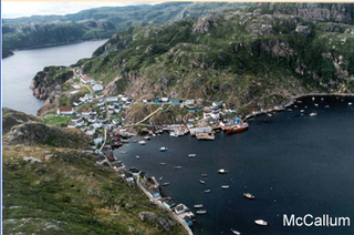
McCallum is a local service district and designated place in the Canadian province of Newfoundland and Labrador. It is on the southern coast of the island of Newfoundland. It is accessible only by boat or by air, and in appearance and way of life is thought by some to be as close to a pre-20th century community as may be found. McCallum lies in an enclosed harbour and is sheltered between two hills. The community survives primarily on the fishery. Whaling was also a major industry in the late 19th century. It is also about an hour and a half from the nearest road, in a community called Hermitage.

Isle aux Morts is a small town on the Southwest Coast of the Island of Newfoundland, with a population of 559 (2021). The town is located approximately 16 km (9.9 mi) east from the Marine Atlantic Ferry Terminal in Port aux Basques along Route 470.
Baie Verte is a town located on the north coast of the island portion of the Canadian province of Newfoundland and Labrador on the Baie Verte Peninsula.

Gaultois is a small settlement in the Coast of Bays area in Newfoundland and Labrador, Canada. Gaultois had a population of 100 people in the 2021 census. The town has a K-12 school called Victoria Academy, as well as a fire department, public library, Lion's Club, and town hall. The town is only accessible by ferry or helicopter. The provincial government ferry runs from the nearby town of Hermitage several times daily and the crossing takes approximately 20 minutes. This ferry also services the more remote community of McCallum once to twice daily with a crossing time of around one hour and fifteen minutes. In 2015, Gaultois voted against resettlement. Gaultois considered resettlement again in 2023 but it failed.
Red Harbour is a Canadian municipality of Newfoundland and Labrador. It is located 20 kilometres northeast of Marystown.
Grand Bruit is a designated place and former settlement in the Canadian province of Newfoundland and Labrador. It is on the southwestern coast of the island of Newfoundland. Grand Bruit was resettled in 2010. The community was divided down the middle by a waterfall, hence the name "Grand Bruit" which is French for "great noise".

Coachman's Cove is a town in the Canadian province of Newfoundland and Labrador. The town had a population of 111 in the Canada 2021 Census.
Fleur de Lys is a town in the Canadian province of Newfoundland and Labrador. The town had a population of 207 in the Canada 2021 Census. Fleur de Lys is located approximately 26 km north of Baie Verte.
Middle Arm is a village in the Canadian province of Newfoundland and Labrador. It is located on the northern shore of an inlet of Notre Dame Bay in the north-central part of Newfoundland.
Ming's Bight is a town in the Canadian province of Newfoundland and Labrador. The town had a population of 298 in 2021 Census, down from 319 in the Canada 2016 Census.
Pacquet is a town in the Canadian province of Newfoundland and Labrador. The town had a population of 164 in 2016, down from 184 in the Canada 2011 Census.
Seal Cove is a town in the Canadian province of Newfoundland and Labrador, located on White Bay. The town has had a stable population of just over 300 for more than a decade.
Harbour Round is a designated place in the Canadian province of Newfoundland and Labrador. It is east of Baie Verte.

Resettlement in Newfoundland and Labrador terms refers to an organized approach to centralize the population into growth areas. It is used in the current context when referring to a voluntary relocation initiated from isolated communities themselves.
Snook's Arm is a designated place in the Canadian province of Newfoundland and Labrador. The community was entirely resettled in 2018.
Norman's Bay is a local service district and designated place in the Canadian province of Newfoundland and Labrador. It is an isolated community at the head of Norman Bay, an extension of Martin Bay. The population of the community was 15 in the 2021 census.
Wild Cove is a local service district and designated place in the Canadian province of Newfoundland and Labrador. It is on the Baie Verte Peninsula of the island of Newfoundland.


