Old Dauphin Way Historic District | |
   | |
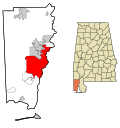
| Location | Roughly bounded by Springhill Ave., Broad, Government, and Houston Sts., Mobile, Alabama |
|---|---|
| Coordinates | 30°41′14.24″N88°4′7.10″W / 30.6872889°N 88.0686389°W |
| Area | 766 acres (310 ha) |
| Built | 1830 |
| Architect | 19th and 20th century revivals, Late Victorian |
| Architectural style | Late 19th And 20th Century Revivals, Late Victorian, Bungalow-Craftsman |
| NRHP reference No. | 84000686 [1] [2] (original) 100007800 (increase) |
| Significant dates | |
| Added to NRHP | 30 August 1984 [1] [2] |
| Boundary increase | June 17, 2022 |
The Old Dauphin Way Historic District is a historic district in the city of Mobile, Alabama, United States. It was named for Dauphin Way, now known as Dauphin Street, which bisects the center of the district from east to west. [3] The district is roughly bounded by Broad Street on the east, Springhill Avenue on the north, Government Street on the south, and Houston Avenue on the west. [2] Covering 766 acres (3.10 km2) and containing 1466 contributing buildings, Old Dauphin Way is the largest historic district in Mobile.
Contents
Although most of the district contains working-class frame houses, large and ornate mansions are found along the main thoroughfares. The contributing buildings range in age from the mid-19th to the early 20th century. Architectural styles include Greek Revival, Gothic Revival, Italianate, Queen Anne, Colonial Revival, Tudor Revival, and American Foursquare. [2]