Old Princes Highway (Victoria)

Last updated

Old Princes Highway

(numerous constituent roads)

Princes Highway, Footscray (50179219746).jpg
Old Princes Highway, Footscray
General information
TypeRoad
Opened10 August 1920;103 years ago (1920-08-10)
Route number(s)
  • AUS Alphanumeric Route A10.svg A10 (2009–present)
    (Waurn Ponds–Corio)
  • AUS Alphanumeric Route C109.svg C109 (1998–present)
    (Cocoroc–Hoppers Crossing)
  • AUS Alphanumeric Route C101.svg C101 (1997–present)
    (Berwick–Nar Nar Goon)
  • AUS Alphanumeric Route C102.svg C102 (1997–present)
    (Drouin–Nilma)
  • AUS Alphanumeric Route C103.svg C103 (1997–present)
    (Moe–Newborough)
  • AUS Alphanumeric Route C104.svg C104 (1997–present)
    (through Morwell)
Former
route number
see Former route allocations
Tourist routesAustralian Tourist Drive 21.svg Tourist Route 21
(Belmont–Corio)
Major junctions
West endAUS Alphanumeric Route M1.svg Geelong Ring Road
Waurn Ponds, Victoria
 
East endAUS Alphanumeric Route M1.svg Princes Highway
Morwell, Victoria
Location(s)
Major suburbs Belmont, Geelong, Corio, Werribee, Hoppers Crossing, Beaconsfield, Pakenham, Drouin, Warragul, Moe, Morwell

Old Princes Highway is a collection of roads, described as any part of an earlier route designated as Princes Highway, located in Victoria, Australia. Sections of the road run through Geelong, Werribee, and through the outer fringes of south-eastern Melbourne eventually to Morwell East. In the time since their de-listing as Princes Highway, many former sections have since been renamed, or have devolved to their original names.

Contents

Route

West

Princes Highway (West) runs from the interstate border with South Australia through western Victoria all the way to the western suburbs of Melbourne, with some towns along this route later bypassed. Old Princes Highway, consisting of former sections of Princes Highway, include: through greater Geelong (from Waurn Ponds to Corio), bypassed by Geelong Ring Road and now allocated route A10; and through Werribee (from Cocoroc to Hoppers Crossing), bypassed by Maltby Bypass and now allocated route C109. One last section runs through western suburban Melbourne, from the interchange with West Gate Freeway and Western Ring Road in Laverton North to Flemington, signposted as both Princes Highway and Geelong Road, but this is still officially gazetted as Princes Highway (West), and the former alignment through central Melbourne was eventually re-declared as their own separate constituent parts.

East

Princes Highway (East) runs from central Melbourne through eastern Victoria all the way to the interstate border with New South Wales, with many of the towns along this route, particularly through Gippsland, later bypassed by sections of Princes Freeway. This first section runs through south-eastern suburban Melbourne, from the intersection with King and Flinders Streets in the Melbourne CBD to the interchange with Monash and Princes Freeways in Narre Warren, signposted as both Princes Highway and Dandenong Road, but is still officially gazetted as Princes Highway (East). Old Princes Highway includes: from Berwick through Beaconsfield and Pakenham to Nar Nar Goon and now allocated route C101; through Drouin and Warragul and more commonly known as Princes Way, now allocated route C102; through Moe and Newborough (along what is now Lloyd Street and Narracan Drive) as route C103, then descending into the La Trobe Valley through the Haunted Hills, along what is now Haunted Hills Road, passed almost due west through what is now the Yallourn Open Cut Mine to join today's Morwell Bridge Road at the Morwell River, and from there, through Morwell along what is now Princes Drive and now allocated route C104.

The first improvements to the route came in the late 1950s when the expansion of the Yallourn open cut necessitated the relocation of the highway. The CRB took this opportunity to provide a high standard access-controlled alignment as well as a bypass of Moe. The first section of the new highway opened in 1959/60 as a single carriageway super-2 expressway between Hernes Oak and the Morwell River. Following in December 1964 was a westerly extension of the super-2 highway from Hernes Oak to Gunns Gully (Newborough) and the Moe Bypass completed the new route - opening in early 1967. The section between Gunns Gully and Hernes Oak inherited the "Haunted Hills" nickname that applied to the original highway between Newborough and Hernes Oak. Duplication of the Moe-Morwell section was commenced after the opening of the Moe Bypass and completed west to Gunns Gully in 1971 and to the western side of Moe in 1979. [1]

It is anticipated that with the future completion of the Traralgon bypass that a new section of the highway will become superseded from the original Highway 1.

History

As a named route, the highway came into being when pre-existing roads were renamed Prince's Highway after the planned visit to Australia by the Prince of Wales (later to become king Edward VIII and, after abdicating, the Duke of Windsor) in 1920. The original submissions in January 1920 were in order for the Prince to have the opportunity during his visit to make the trip from Melbourne to Sydney overland along the route. That idea never came to fruition, but the prince did give his permission for the naming. [2] The Victorian section of the highway had an opening ceremony when the first section of road from Melbourne was opened on 10 August 1920 in Warragul. [2]

Approval was later given by the Victorian executive in January 1922 to extend the highway west from Melbourne through Geelong, Camperdown, Warrnambool and Portland to the South Australian border. [3] The passing of the Highways and Vehicles Act of 1924 [4] through the Parliament of Victoria provided for the declaration of State Highways, roads two-thirds financed by the State government through the Country Roads Board (later VicRoads). Prince's Highway was declared a State Highway on 1 July 1925, traversing the whole length of the State from its western boundary near Mount Gambier in South Australia, through Port Fairy, Warrnambool, Geelong to Melbourne, through Dandenong, Warragul, Sale, Bairnsdale and Orbost to the eastern boundary of the state towards Eden in New South Wales (for a total of 540 miles). [5]

The passing of the Road Management Act 2004 [6] through the Parliament of Victoria granted the responsibility of overall management and development of Victoria's major arterial roads to VicRoads: VicRoads re-declared the road in 2010 as Princes Highway West (Arterial #6500), beginning at the state border with South Australia to Geelong, then from Altona North to Parkville; [7] and in 2008 as Princes Highway East (Arterial #6510), beginning at the Melbourne CBD to Narre Warren, then through Yarragon, Trafalgar and Morwell, the from Morwell to the state border with New South Wales. [8]

Portions of both the western and eastern section of Princes Highway have further devolved with their own classification and names: the section through Geelong (from Waurn Ponds to Corio) was re-declared in 2012 as Corio–Waurn Ponds Road (Arterial #6800) [9] (following the opening of Geelong Ring Road); the section through Werribee (from Cocoroc to Hoppers Crossing) was re-declared in 2004 as Werribee Main Road (Arterial #5445); [10] the section through outer south-eastern Melbourne (from Berwick to Nar Nar Goon) was re-declared in 2004 as Berwick-Beaconsfield Road (Arterial #5163) [11] and in 2007 as Beaconsfield-Nar Nar Goon Road (Arterial #6460); [12] the section through Drouin and Warragul (signposted as Princes Way) was re-declared in 2004 as Drouin–Warragul Road (Arterial #5594); [13] the section through Moe (signposted as Lloyd Street and Narracan Drive) was re-declared in 2004 as part of Moe-Glengarry Road (Arterial #5539); [14] and the section through Morwell (signposted as Princes Drive) was re-declared in 2004 as part of Morwell-Traralgon Road (Arterial #5921). [15]

The former alignment of Princes Highway through central Melbourne from Parkville to the southern border of the CBD – along Flemington Road (Arterial #5044), [16] Harker Street (Arterial #5026), [17] Curzon Street (Arterial #5027), [18] and King Street (Arterial #5041), [19] – devolved back to their own identities in 2004, no longer part of Princes Highway but not referenced as Old Princes Highway.

Former route numbers

Old Princes Highway has many former route allocations including former National Route 1; its routing through Melbourne and along present sections of Princes Highway have been included for sake of completion. Where and when the former route numbers were implemented are stated below.

through Waurn Ponds:

Waurn Ponds – Corio:

Cocoroc – Hoppers Crossing:

Brooklyn – North Melbourne:

North Melbourne – Parkville:

Parkville – Hallam:

Hallam – Narre Warren:

Berwick – Beaconsfield:

Beaconsfield – Nar Nar Goon:

Drouin – Nilma:

Moe – Newborough:

Morwell – East Morwell:

Major intersections

Waurn Ponds–Corio

LocationkmmiDestinationsNotes
Corio AUS Alphanumeric Route M1.svgAustralian Tourist Drive 21.svgWestern Australia MR-SM-11.svg Princes Freeway (M1/Tourist Route 21)  Melbourne, Avalon Airport
AUS Alphanumeric Route C114.svg Forest Road South (C114)  Lara
AUS Alphanumeric Route C116.svg Station Street (C116)
CorioNorlane boundaryAUS Alphanumeric Route C704.svg Bacchus Marsh Road (C704 north)  Bacchus Marsh
AUS Alphanumeric Route C136.svg Cox Road (C136 west)  Bell Park, Bell Post Hill, Lovely Banks
St. Georges Road (east)
Norlane AUS Alphanumeric Route C116.svg The Boulevard (C116 west)  Norlane
AUS Alphanumeric Route C116.svg North Shore Road (C116 east)  North Shore
North Geelong AUS Alphanumeric Route C117.svg Separation Street (C117)  Bell Park
AUS Alphanumeric Route C115.svg Corio Quay Road (C115)  North Shore, Corio
Geelong CBD AUS Alphanumeric Route A300.svg Church Street (A300)  North Geelong, Ballarat
AUS Alphanumeric Route B140.svg Aberdeen Street (B140 west)  Geelong West, Hamilton
AUS Alphanumeric Route C123.svg Ryrie Street (C123 east)  East Geelong, Portarlington
AUS Alphanumeric Route B110.svg McKillop Street (B110)  East Geelong, Queenscliff
South Geelong AUS Alphanumeric Route C112.svg West Fyans Street (C112 west)  Newtown
AUS Alphanumeric Route C112.svg Fyans Street (C112 east)  South Geelong
Belmont AUS Alphanumeric Route C121.svg Barwon Heads Road (C121)  Barwon Heads
AUS Alphanumeric Route C124.svg Breakwater Road (C124)  Breakwater
AUS Alphanumeric Route B100.svgAustralian Tourist Drive 21.svg Surf Coast Highway (B100/Tourist Route 21)  Torquay
HightonGrovedale boundaryAUS Alphanumeric Route C133.svg South Valley Road (C133)  Highton
AUS Alphanumeric Route C133.svg Pioneer Road (C133)  Grovedale
HightonGrovedaleWaurn Ponds tripoint AUS Alphanumeric Route M1.svg Geelong Ring Road (M1)  Melbourne
Waurn Ponds AUS Alphanumeric Route M1.svg Geelong Ring Road (M1)  Colac
1.000 mi = 1.609 km; 1.000 km = 0.621 mi
  •        Route transition

Cocoroc–Hoppers Crossing

LGALocationkmmiDestinationsNotes
AUS Alphanumeric Route M1.svg Princes Freeway (M1)  Melbourne
AUS Alphanumeric Route C701.svg Old Geelong Road (C701)  Williams Landing
AUS Alphanumeric Route C702.svg Derrimut Road (C702)  Truganina
Sneydes Road  Point Cook
Tarneit Road  Tarneit
AUS Alphanumeric Route C108.svgAustralian Tourist Drive 11.svg Duncans Road (C108/Tourist Route 11)  Werribee South
AUS Alphanumeric Route C703.svg Werribee Street North (C703)  Werribee
AUS Alphanumeric Route M1.svg Princes Freeway (M1)  Melbourne, Geelong
1.000 mi = 1.609 km; 1.000 km = 0.621 mi
  •        Route transition

Laverton North–Southbank

LGALocationkmmiDestinationsNotes
Australian national route ALT1.svg Kings Way (Alt National Route 1) – Dandenong
AUS Alphanumeric Route M1 toll.svg CityLink (M1 east)  Dandenong
Moray Street
Whiteman Street
Australian state route 30.svg Flinders Street (Metro Route 30)
Flinders Lane
Collins Street
Little Collins Street
Bourke Street
Little Bourke Street
Lonsdale Street
Little Lonsdale Street
La Trobe Street
Australian state route 32.svgAustralian state route 55.svg Dudley Street (Metro Routes 32/55)
Hawke Street
Victoria Street
Queensberry Street
Arden Street
Australian state route 60.svg Flemington Road (Metro Route 60)
Abbotsford Street
Australian state route 83.svg Elliott Avenue (Metro Route 83)  Parkville
Australian state route 60.svg Flemington Road (Metro Route 60)  Flemington
Boundary Road, Travancore, North Melbourne
AUS Alphanumeric Route M2 toll.svg CityLink (M2) Docklands, Port Melbourne
Stubbs Street  Kensington
Racecourse Road, Ascot Vale
Australian state route 35.svg Epsom Road (Metro Route 35), Kensington, Ascot Vale
Australian state route 35.svg Moore Street (Metro Route 35)
Australian state route 8.svg Ballarat Road (Metro Route 8)
Droop Street
Barkly Street
Australian state route 37.svg Gordon Street (Metro Route 37)
Australian state route 32.svg Buckley Street (Metro Route 32)
Australian state route 37.svg Geelong Street (Metro Route 37)
Australian state route 50.svg Somerville Road (Metro Route 50 east)
Australian state route 41.svg Millers Road (Metro Route 41 south)
Francis Street (east)
Australian state route 39.svgAustralian state route 41.svg McDonald Road (Metro Routes 39/41)
Australian state route 39.svg Grieve Parade (Metro Route 39)
Little Boundary Road
AUS Alphanumeric Route M1.svg Princes Freeway (M1), Geelong
1.000 mi = 1.609 km; 1.000 km = 0.621 mi
  •        Route transition

Southbank–Narre Warren

LGALocationkmmiDestinationsNotes
Casey Narre WarrenBerwick boundary00.0AUS Alphanumeric Route C101.svg Princes Highway (C101 east)  Berwick
AUS Alphanumeric Route M1.svg Princes Freeway (M1 southeast), Warragul
AUS Alphanumeric Route M1.svg Monash Freeway (M1 northwest) – City
Diamond interchange
Narre Warren 1.20.75AUS Alphanumeric Route C404.svg Narre Warren North Road (C404 north)  Belgrave
AUS Alphanumeric Route C404.svg Narre Warren–Cranbourne Road (C404 south)  Cranbourne
Hallam 4.93.0 Hallam South Road (south)  Hallam
AUS Alphanumeric Route B675.svg Belgrave–Hallam Road (B675 north)  Endeavour Hills
CaseyGreater Dandenong boundary Dandenong SouthHallamEumemmerring tripoint 6.74.2AUS Alphanumeric Route M420.svg South Gippsland Freeway (M420) – City, Hastings Diamond interchange
Greater Dandenong DandenongDandenong South boundary95.6 South Gippsland Highway   Phillip Island
Dandenong 9.86.1Australian state route 9.svg Frankston–Dandenong Road (Metro Route 9)  Frankston
10.76.6Australian state route 9.svg Foster Street (Metro Route 9 east)  Rowville
Australian state route 10.svg Foster Street (Metro Route 10 west)  Mentone
13.68.5To Australian state route 14.svg Heatherton Road (Metro Route 14)  Noble Park, Endeavour Hills
Dandenong NorthDandenongNoble ParkNoble Park North quadripoint 13.88.6AUS Alphanumeric Route M3 toll.svg EastLink (M3)  Ringwood, Frankston Diamond interchange
MonashGreater Dandenong boundary MulgraveSpringvale boundary18.911.7Australian state route 16.svg Police Road (Metro Route 16 east)  Mulgrave
Australian state route 16.svg Centre Road (Metro Route 16 west)  Brighton East
Springvale Junction
1912Australian state route 40.svg Springvale Road (Metro Route 40)  Springvale, Glen Waverley
ClaytonSpringvale boundary20.412.7Australian state route 49.svg Westall Road (Metro Route 49)  Springvale South
Monash Clayton 20.913.0Australian state route 13.svg Blackburn Road (Metro Route 13)  Blackburn
22.213.8Australian state route 18.svg Wellington Road (Metro Route 18 east)  Rowville
Australian state route 18.svg North Road (Metro Route 18 west)  Oakleigh
ClaytonOakleigh East boundaryAustralian state route 23.svg Clayton Road (Metro Route 23)  Clayton, Burwood
OakleighOakleigh EastHuntingdale tripoint Australian state route 47.svg Huntingdale Road (Metro Route 47)  Huntingdale
OakleighOakleigh East boundaryAustralian state route 22.svg Ferntree Gully Road (Metro Route 22)  Ferntree Gully Concurrency with Metro Route 22
MonashStonnington boundary OakleighMalvern EastHughesdale tripoint Australian state route 15.svg Warrigal Road (Metro Route 15)
Glen EiraStonnington boundary CarnegieMalvern EastMurrumbeena tripoint Australian state route 22.svg Murrumbeena Road (Metro Route 22 south)
Belgrave Road
Caulfield EastMalvern EastCarnegie tripoint Australian state route 17.svg Grange Road (Metro Route 17)Concurrency with Metro Route 17
Caulfield EastMalvern East boundaryAustralian state route 17.svg Burke Road (Metro Route 17)
Caulfield NorthMalvern boundaryAustralian state route 19.svg Glenferrie Road (Metro Route 19 north)  Hawthorn Concurrency with Metro Route 19
Australian state route 19.svg Hawthorn Road (Metro Route 19 south)  Caulfield
Port PhillipStonnington boundary St Kilda EastPrahranWindsor tripoint Australian state route 25.svg Hotham Street (Metro Route 25 south)
Australian state route 25.svg Williams Road (Metro Route 25 north)
St KildaWindsor boundary Chapel Street
Australian state route 3.svg St Kilda Road (Metro Route 3)
Australian state route 29.svg Punt Road (Metro Route 29)
Port Phillip Melbourne CBDAlbert Park boundaryAustralian state route 24.svg Lorne Street (Metro Route 24)
Melbourne CBD Australian state route 26.svg Toorak Road (Metro Route 26 east)  Toorak Concurrency with Metro Route 26
Melbourne CBDSouth Melbourne boundaryAustralian state route 26.svg Albert Road (Metro Route 26 west)
Port PhillipMelbourne boundary Southbank AUS Alphanumeric Route M1.svg West Gate Freeway (M1), Geelong
AUS Alphanumeric Route M1 toll.svg CityLink (M1), Dandenong
Australian state route 60.svg Kings Way (Metro Route 60) – City

Berwick–Nar Nar Goon

LGALocationkmmiDestinationsNotes
Cardinia Nar Nar Goon 00.0AUS Alphanumeric Route M1.svg Princes Freeway (M1 east)  Warragul
AUS Alphanumeric Route M1.svg Princes Freeway (M1 west) – Melbourne
AUS Alphanumeric Route C433.svg Nar Nar Goon Connection Road  Nar Nar Goon
Pakenham 6.13.8AUS Alphanumeric Route C422.svg Racecourse Road (C422)  Koo Wee Rup
7.74.8C695 McGregor Road (C695)  Rythdale
8.65.3AUS Alphanumeric Route C411.svg Pakenham Road (C411)  Healesville
Officer 11.47.1AUS Alphanumeric Route C417.svg Cardinia Road (C417)  Cardinia
Beaconsfield 16.510.3AUS Alphanumeric Route A17.svgAUS Alphanumeric Route B668.svg O'Shea Road (A17/B668)  Hampton Park
18.311.4AUS Alphanumeric Route C406.svg Beaconsfield-Emerald Road (C406)  Emerald
Casey Berwick 20.812.9AUS Alphanumeric Route C407.svg Clyde Road (C407 south)  Clyde
Australian state route 61.svg Lyall Road (Metro Route 61 north)  Harkaway
22.814.2AUS Alphanumeric Route M1.svg Monash Freeway (M1 northeast)  Melbourne
AUS Alphanumeric Route M1.svg Princes Freeway (M1 southeast)  Warragul
Australian national route ALT1.svg Princes Highway (Alt National Route 1 west)  Dandenong
1.000 mi = 1.609 km; 1.000 km = 0.621 mi
  •        Route transition

Drouin–Nilma

LGALocationkmmiDestinationsNotes
AUS Alphanumeric Route M1.svg Princes Freeway (M1)  Traralgon, Melbourne
AUS Alphanumeric Route C462.svg Bloomfield Road
AUS Alphanumeric Route C425.svg
AUS Alphanumeric Route M1.svg Princes Freeway (M1)  Traralgon, Melbourne
AUS Alphanumeric Route C431.svg Main South Road (C431)
AUS Alphanumeric Route C426.svg Main Neerim Road (C426)
AUS Alphanumeric Route C433.svg Wellwood Road (C433)
AUS Alphanumeric Route M1.svg Princes Freeway (M1)  Melbourne, Warragul
1.000 mi = 1.609 km; 1.000 km = 0.621 mi
  •        Route transition

Moe–Newborough

LGALocationkmmiDestinationsNotes
AUS Alphanumeric Route M1.svg Princes Highway (M1)  Traralgon
Old Gippsland Drive – Melbourne via AUS Alphanumeric Route M1.svg Princes Freeway (M1)
AUS Alphanumeric Route C466.svg Anzac Street
AUS Alphanumeric Route C103.svg John Field Drive (C103)
AUS Alphanumeric Route M1.svg Princes Freeway (M1)  Melbourne, Traralgon
1.000 mi = 1.609 km; 1.000 km = 0.621 mi
  •        Route transition

Morwell

LGALocationkmmiDestinationsNotes
AUS Alphanumeric Route M1.svg Princes Freeway (M1)  Sale
AUS Alphanumeric Route C105.svg Traralgon-Maffra Road (C105)
AUS Alphanumeric Route C477.svg Grey Street (C477)
AUS Alphanumeric Route C482.svg Shakespeare Street (C482)
AUS Alphanumeric Route C474.svg Tramway Road (C474)Concurrency with C474
AUS Alphanumeric Route C474.svg Alexanders Road (C474)
AUS Alphanumeric Route C456.svg Monash Way (C456)
AUS Alphanumeric Route C475.svg Commercial Road (C475)
AUS Alphanumeric Route B460.svg Commercial Road (B460)
AUS Alphanumeric Route M1.svg Princes Freeway (M1) – Melbourne
1.000 mi = 1.609 km; 1.000 km = 0.621 mi
  •        Route transition

See also

Related Research Articles

<span class="mw-page-title-main">Princes Highway</span> Highway in Australia

Princes Highway is a major road in Australia, extending from Sydney via Melbourne to Adelaide through the states of New South Wales, Victoria and South Australia. It has a length of 1,941 kilometres (1,206 mi) or 1,898 kilometres (1,179 mi) via the former alignments of the highway, although these routes are slower and connections to the bypassed sections of the original route are poor in many cases.

<span class="mw-page-title-main">Nepean Highway</span> Highway in Victoria, Australia

Nepean Highway is a major highway in Victoria, running south from St Kilda Junction in inner-southern Melbourne to Portsea, tracing close to the eastern shore of Port Phillip for the majority of its length. It is the primary road route from central Melbourne through Melbourne's southern suburbs. This name covers a few consecutive roads and is not widely known to most drivers except for its central section, as the entire allocation is still best known by the names of its constituent parts: St Kilda Road, Brighton Road and Nepean Highway proper, and Point Nepean Road. This article will deal with the entire length of the corridor for sake of completion.

South Gippsland Highway is a partially divided highway connecting the south-eastern suburbs of Melbourne through the South Gippsland region of in Victoria, Australia to the town of Sale. The highway serves as a gateway from Melbourne to many attractions including Wilsons Promontory and Phillip Island as well as being an important road for farmers in Gippsland.

<span class="mw-page-title-main">Hoddle Highway</span> Highway in Melbourne, Victoria

Hoddle Highway is an urban highway in Melbourne linking CityLink and the Eastern Freeway, itself a sub-section of Hoddle Main Road. Both these names are not widely known to most drivers, as the entire allocation is still best known as by the names of its constituent parts: Hoddle Street, Punt Road and Barkly Street. This article will deal with the entire length of the corridor for sake of completion.

<span class="mw-page-title-main">West Gate Freeway</span> Freeway in Melbourne, Australia

The West Gate Freeway is a major freeway in Melbourne, the busiest urban freeway and the busiest road in Australia, carrying upwards of 200,000 vehicles per day. It links Geelong and Melbourne's western suburbs to central Melbourne and beyond. It is also a link between Melbourne and the west and linking industrial and residential areas west of the Yarra River with the city and port areas. The West Gate Bridge is a part of the freeway.

<span class="mw-page-title-main">Monash Freeway</span> Freeway in Victoria, Australia

The Monash Freeway is a major urban freeway in Victoria, Australia, linking Melbourne's CBD to its south-eastern suburbs and beyond to the Gippsland region. It carries up to 180,000 vehicles per day and is one of Australia's busiest freeways. The entire stretch of the Monash Freeway bears the designation M1.

<span class="mw-page-title-main">Calder Highway</span> Highway in Victoria

Calder Highway is a rural highway in Australia, linking Mildura and the Victoria/New South Wales border to Bendigo, in North Central Victoria. South of Bendigo, where the former highway has been upgraded to freeway-standard, Calder Freeway links to Melbourne, subsuming former alignments of Calder Highway; the Victorian Government completed the conversion to freeway standard from Melbourne to Bendigo on 20 April 2009.

<span class="mw-page-title-main">Princes Freeway</span> Freeway in Victoria, Australia

Princes Freeway is a 159-kilometre (99 mi) Australian freeway, divided into two sections, both located in Victoria, Australia. The freeway links Melbourne to Geelong in the west, and to Morwell in the east. It continues beyond these extremities as the Princes Highway towards Adelaide to the west and Sydney to the northeast. The freeway bears the designation M1.

Moorooduc Highway is a 16 km highway which runs from Frankston to Tuerong and, together with the Mornington Peninsula Freeway, was part of the main route from Melbourne to the Mornington Peninsula until the completion of Peninsula Link in 2013. This name is not widely known to most drivers, as the entire allocation is still best known as by the names of its constituent parts: McMahons Road, Frankston–Flinders Road, and Moorooduc Road.

<span class="mw-page-title-main">Geelong Ring Road</span> Freeway in Victoria, Australia

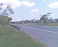
The Geelong Ring Road is a freeway ring road in Australia beside Geelong's western suburbs from the Princes Freeway at Corio to the Princes Highway at Waurn Ponds. It also connects to the Midland Highway towards Ballarat, and the Hamilton Highway.

Midland Highway is a major rural highway linking major towns in Victoria, beginning from Geelong and winding through country Victoria in a large arc through the cities of Ballarat, Bendigo and Shepparton, eventually reaching Mansfield at the foothills of the Victorian Alps.

<span class="mw-page-title-main">Greensborough Highway</span>

Greensborough Highway is a highway in the north-eastern suburbs of Melbourne, Australia, and is an important route for north-east Melbourne. This name is not widely known to most drivers, as the entire allocation is still best known as by the names of its constituent parts: Lower Heidelberg Road, Rosanna Road, Lower Plenty Road, Greensborough Road and Greensborough Bypass. This article will deal with the entire length of the corridor for sake of completion.

Warrigal Road is a major inner urban road in southeastern Melbourne, Australia. On weekdays, it is heavily trafficked as it runs through many major suburbs along its route, traversing some of Melbourne's eastern and south-eastern suburbs. These suburbs include Chadstone, Oakleigh, and Cheltenham. The Chadstone Shopping Centre can be accessed directly from Warrigal Road at its eastern entrance.

<span class="mw-page-title-main">Docklands Highway</span>

Docklands Highway is an urban highway stretching 12 kilometres from Brooklyn in Melbourne's inner western suburbs to the Docklands precinct, adjacent to the city. This name covers many consecutive streets and is not widely known to most drivers, as the entire allocation is still best known as by the names of its constituent parts: Francis Street, Whitehall Street, Moreland Street, Napier Street, Footscray Road, Dudley Street and Wurundjeri Way. This article will deal with the entire length of the corridor for sake of completion, as well to avoid confusion between declarations.

<span class="mw-page-title-main">Beach Road, Melbourne</span> Road in Melbourne, Victoria

Beach Road is a coastal suburban road in Melbourne, Australia that runs along the northeastern shore of Port Phillip Bay, from Bay Street in Port Melbourne to its southern point in Mordialloc. This name covers many consecutive streets and is not widely known to most drivers except for the southernmost section, as the entire allocation is still best known as by the names of its constituent parts: Beach Street, Beaconsfield Parade, Jacka Boulevard, Marine Parade, Ormond Esplanade, St Kilda Street, Esplanade and Beach Road proper. This article will deal with the entire length of the corridor for sake of completion.

<span class="mw-page-title-main">Ballarat Road</span> Road in Melbourne, Victoria

Ballarat Road is a major urban arterial road in the western suburbs of Melbourne, Victoria, Australia.

<span class="mw-page-title-main">M80 Ring Road</span> Freeway in Melbourne, Australia

The M80 Ring Road is a partially complete urban freeway ring road around Melbourne, Australia. This article will deal with the entire length of the corridor for sake of completion, as well to avoid confusion between declarations.

<span class="mw-page-title-main">Highway 1 (Victoria)</span>

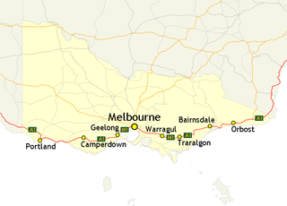
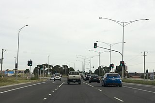
In Victoria, Highway 1 is a 958-kilometre (595 mi) long route that follows the coastline of the state, from the New South Wales border near Genoa to the South Australian border near Dartmoor. Highway 1 continues around the rest of Australia, joining all mainland state capitals, and connecting major centres in Tasmania. All roads within the Highway 1 system are allocated a road route numbered 1, M1, A1, or B1, depending on the state route numbering system. In Victoria, the highway is designated as route M1 between Traralgon and Winchelsea, and route A1 elsewhere.

Surfcoast Highway is a semi-rural highway in Victoria, Australia, connecting the city of Geelong with the coastal town of Torquay. The highway runs through the Armstrong Creek Growth Area, which is the subject of extensive residential development; closer to Torquay, tourist attractions the Narana Creations indigenous centre, Surf Coast Plaza retail centre, and the Surfworld museum are located along the highway.

References

  1. , M1 Princes Hwy/Fwy East, Former Alignments: Moe to Morwell. Retrieved on 15 October 2012.[ self-published source ]
  2. 1 2 "PRINCE'S HIGHWAY". The Argus . Melbourne: National Library of Australia. 11 August 1920. p. 9. Retrieved 8 September 2011.
  3. "PRINCE'S HIGHWAY". The Argus . Melbourne: National Library of Australia. 25 January 1922. p. 12. Retrieved 8 September 2011.
  4. State of Victoria, An Act to make further provision with respect to Highways and Country Roads Motor Cars and Traction Engines and for other purposes 30 December 1924
  5. "Country Roads Board Victoria. Twelfth Annual Report: for the year ended 30 June 1925". Country Roads Board of Victoria. Melbourne: Victorian Government Library Service. 31 December 1925. p. 3.
  6. State Government of Victoria. "Road Management Act 2004" (PDF). Government of Victoria. Archived (PDF) from the original on 18 October 2021. Retrieved 19 October 2021.
  7. VicRoads. "VicRoads – Register of Public Roads (Part A) 2015" (PDF). Government of Victoria. pp. 976–8. Archived from the original on 1 May 2020. Retrieved 19 October 2021.
  8. VicRoads. "VicRoads – Register of Public Roads (Part A) 2015" (PDF). Government of Victoria. pp. 979–83. Archived from the original on 1 May 2020. Retrieved 19 October 2021.
  9. VicRoads. "VicRoads – Register of Public Roads (Part A) 2015" (PDF). Government of Victoria. pp. 1034–5. Archived from the original on 1 May 2020. Retrieved 19 October 2021.
  10. VicRoads. "VicRoads – Register of Public Roads (Part A) 2015" (PDF). Government of Victoria. p. 514. Archived from the original on 1 May 2020. Retrieved 19 October 2021.
  11. VicRoads. "VicRoads – Register of Public Roads (Part A) 2015" (PDF). Government of Victoria. p. 278. Archived from the original on 1 May 2020. Retrieved 19 October 2021.
  12. VicRoads. "VicRoads – Register of Public Roads (Part A) 2015" (PDF). Government of Victoria. p. 975. Archived from the original on 1 May 2020. Retrieved 19 October 2021.
  13. VicRoads. "VicRoads – Register of Public Roads (Part A) 2015" (PDF). Government of Victoria. p. 623. Archived from the original on 1 May 2020. Retrieved 19 October 2021.
  14. VicRoads. "VicRoads – Register of Public Roads (Part A) 2015" (PDF). Government of Victoria. p. 623. Archived from the original on 1 May 2020. Retrieved 19 October 2021.
  15. VicRoads. "VicRoads – Register of Public Roads (Part A) 2015" (PDF). Government of Victoria. p. 876. Archived from the original on 1 May 2020. Retrieved 19 October 2021.
  16. VicRoads. "VicRoads – Register of Public Roads (Part A) 2015" (PDF). Government of Victoria. p. 157. Archived from the original on 1 May 2020. Retrieved 19 October 2021.
  17. VicRoads. "VicRoads – Register of Public Roads (Part A) 2015" (PDF). Government of Victoria. p. 138. Archived from the original on 1 May 2020. Retrieved 19 October 2021.
  18. VicRoads. "VicRoads – Register of Public Roads (Part A) 2015" (PDF). Government of Victoria. p. 139. Archived from the original on 1 May 2020. Retrieved 19 October 2021.
  19. VicRoads. "VicRoads – Register of Public Roads (Part A) 2015" (PDF). Government of Victoria. pp. 153–4. Archived from the original on 1 May 2020. Retrieved 19 October 2021.