

The following outline is provided as an overview of and topical guide to Zimbabwe:
Contents
- General reference
- Geography of Zimbabwe
- Environment of Zimbabwe
- Regions of Zimbabwe
- Demography of Zimbabwe
- Government and politics of Zimbabwe
- Branches of the government of Zimbabwe
- Foreign relations of Zimbabwe
- Law and order in Zimbabwe
- Military of Zimbabwe
- Local government in Zimbabwe
- History of Zimbabwe
- By period
- By field
- Culture of Zimbabwe
- Art in Zimbabwe
- Sports in Zimbabwe
- Economy and infrastructure of Zimbabwe
- Economic sectors
- Education in Zimbabwe
- Health in Zimbabwe
- See also
- Notes
- References
- External links
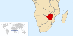
Zimbabwe – landlocked sovereign country located in Southern Africa, between the Zambezi River and Limpopo River. [1]


