Paddington tube station (Circle and Hammersmith & City lines)

Last updated

Paddington Underground no-text.svg
Paddington Bishop's Street station entrance front.jpg
Entrance from Paddington Basin
Open street map central london.svg
Red pog.svg
Paddington
Location of Paddington in Central London
Location Paddington
Local authority City of Westminster
Managed by London Underground
Number of platforms2 [1]
AccessibleYes [2]
Fare zone 1
OSI Paddington National Rail logo.svg Elizabeth line roundel (no text).svg Heathrow Express icon RDT.svg
Paddington Bakerloo, Circle and District line station Underground no-text.svg [3]
London Underground annual entry and exit
2018Decrease2.svg 44.60 million [4]
2019Increase2.svg 48.61 million [5]
2020Decrease2.svg 11.42 million [6]
2021Increase2.svg 20.44 million [7]
2022Increase2.svg 46.65 million [8]
Key dates
10 January 1863Opened (as terminus)
13 June 1864Extension (to Hammersmith)
1 August 1872Started ("Middle Circle")
31 January 1905Ended ("Middle Circle")
30 July 1990Started (Hammersmith & City)
13 December 2009Started (Circle line to Hammersmith)
Other information
External links
WGS84 51°31′07″N0°10′43″W / 51.5186°N 0.1785°W / 51.5186; -0.1785
Underground sign at Westminster.jpg  London transportportal

Paddington is a London Underground station served by the Circle and Hammersmith & City lines. It is located adjacent to the north side of Paddington mainline station and has entrances from within the mainline station and from Paddington Basin. The station is between Royal Oak and Edgware Road and is in London Fare Zone 1.

Contents

The station is one of two separate Underground stations of the same name. The other station, on Praed Street to the south of the mainline station, is served by the Bakerloo, Circle and District lines. Although shown on the London Underground map as a single station, [9] the two stations are not directly linked and interchange between them is via the concourse of the mainline station.

History

Metropolitan Railway

Paddington Bishop's Road station, 1862.jpg
Exterior, 1862
Paddington station on 1874 OS Map.jpg
Metropolitan Railway station between Paddington GWR passenger and goods stations, 1874

The station was opened as Paddington (Bishop's Road) by the Metropolitan Railway (MR, later the Metropolitan line) on 10 January 1863 as the western terminus of the world's first underground railway. [10] [n 1] The station building was located on the road bridge carrying Bishop's Road (now Bishop's Bridge Road) over the mainline tracks of the Great Western Railway (GWR). [n 2] Services were initially operated with rolling stock provided by the GWR, [13] and the MR route to Farringdon was laid with dual-gauge track for both broad-gauge and standard-gauge trains. [14] [n 3]

On 9 May 1864, the boiler exploded on the engine of a train about to leave the station eastbound. [n 4] The driver and fireman, a member of staff on the platform and a passenger on a train arriving from the east were injured. The explosion threw fragments of the boiler up to 404 feet (123 m) away. The canopy and end screen of the station's roof, the side wall of the platform stairs and the carriage of the arriving train were all damaged. [16]

On 13 June 1864, GWR services were extended westward when the Hammersmith & City Railway (H&CR) opened to Hammersmith. [10] [17] [n 5] MR services began operating to Hammersmith in 1865. [18] Initially, trains ran for about 1 mile (1.6 km) on the GWR's mainline tracks between Paddington and the start of the Hammersmith branch, [17] but delays on the mainline section led to a separate pair of parallel tracks for the Hammersmith service being constructed. These opened on 30 October 1871. [17]

On 1 October 1868, the MR opened a south-west facing junction (Praed Street junction) approximately 350 yards (320 m) west of Edgware Road for a new branch to Gloucester Road. [10] [1] [n 6] MR trains to Gloucester Road served a separate station named Paddington (Praed Street) south of the main-line station. [10] Paddington (Bishop's Road) station was given its current name on 10 September 1933. [10]

From 1 August 1872, the '"Middle Circle"' service also began operations through the station running from Moorgate then over the Hammersmith branch to Latimer Road then, via a now demolished link, to the West London Line to Addison Road and the District Railway (DR, later the District line) to Mansion House. [19] The service was operated jointly by the GWR and the DR. The service ended on 31 January 1905. [20]

Until 1990, services through the station were shown on maps as part of the MR and, later the Metropolitan line. They were separately identified as the Hammersmith & City line in 1990. [10]

Circle line

Entrance from the mainline station Paddington station MMB 82.jpg
Entrance from the mainline station

In December 2009, Circle line services began serving the station. Originally operating as a loop-line using tracks constructed by the MR and the DR and serving only the station in Praed Street, the Circle line's route was altered to include the Hammersmith branch to increase train frequency on the branch and improve the regularity of Circle line trains. Trains run in a spiral anti-clockwise from Edgware Road around the loop, back to Edgware Road and then on to the Hammersmith branch. [21] [n 7]

The station was rebuilt during 2012 and 2013 to provide longer platforms, improved access and connections to the mainline station. A new entrance to Paddington Basin was opened. [23]

Accidents and incidents

On 9 May 1864, the boiler of a Great Northern Railway 0-6-0 locomotive exploded as it was leaving Bishops Road. Two people were seriously injured and the resulting debris landed up to 250 yards (230 m) away, and a section of the main station roof was dented. [24]

Services

The station is in London Fare Zone 1 between Royal Oak and Edgware Road stations. Train frequencies vary throughout the day, but, generally, Hammersmith & City line trains operate every 10 minutes from approximately 04:50 to 00:42 eastbound and 05:22 to 00:53 westbound; they are supplemented by Circle line trains every 10 minutes from approximately 04:58 to 23:43 eastbound and 06:40 to 00:45 westbound. [25] Both lines use the same tracks. [1]

Preceding station Underground no-text.svg London Underground Following station
Royal Oak
towards Hammersmith
Circle line
Edgware Road
towards Edgware Road via  Aldgate
Hammersmith & City line Edgware Road
towards Barking
Former services
Royal Oak
towards Hammersmith
Metropolitan line
Hammersmith branch (1864–1990)
Edgware Road
towards Barking

Connections

London Buses routes serve Bishop's Bridge Road, north of the station. Other bus routes serve the station in Praed Street. [26]

Notes and references

Notes

  1. The Metropolitan Railway ran mostly in shallow tunnels constructed using the cut-and-cover technique under existing roads. Some sections of the trench were left un-roofed for ventilation. Some station platforms were below ground level within the roofed sections of tunnel but others, such as Paddington (Bishop's Road) had glazed roofs. [11]
  2. The Metropolitan Railway's chief engineer was John Fowler. [12]
  3. A falling out between the managers of the GWR and MR led to the GWR withdrawing its trains from the MR's use in August 1863, [13] though it continued to operate its own suburban services over the MR's tracks. [15] The MR hired standard gauge rolling stock from the Great Northern Railway and London & North Western Railway whilst it had its own constructed. [13]
  4. The engine was one of those hired from the Great Northern Railway following the Metropolitan Railway's dispute with the Great Western Railway.
  5. The Hammersmith & City Railway was promoted jointly by the GWR and MR, but established as a separate company. It was jointly controlled by the two companies from 1 July 1865. [17]
  6. The branch to Gloucester Road met the District Railway there and, with later extensions of both lines towards the City of London eventually formed the Inner Circle (now the Circle line). [10]
  7. Although the two Paddington Underground stations are only about 400 metres (440 yd) apart geographically, the distance by rail on the Circle line without changing trains is 20.84 kilometres (12.95 mi) around almost the whole of the line's loop section. [22]

Related Research Articles

<span class="mw-page-title-main">Circle line (London Underground)</span> London Underground line

The Circle line is a spiral-shaped London Underground line, running from Hammersmith in the west to Edgware Road and then looping around central London back to Edgware Road. The railway is below ground in the central section and on the loop east of Paddington. Unlike London's deep-level lines, the Circle line tunnels are just below the surface and are of similar size to those on British main lines. Printed in yellow on the Tube map, the 17-mile (27 km) line serves 36 stations, including most of London's main line termini. Almost all of the route, and all the stations, are shared with one or more of the three other sub-surface lines, namely the District, Hammersmith & City and Metropolitan lines. On the Circle and Hammersmith & City lines combined, over 114 million passenger journeys were recorded in 2011/12.

<span class="mw-page-title-main">Hammersmith & City line</span> London Underground line

The Hammersmith & City line is a London Underground line that runs between Hammersmith in west London and Barking in east London. Coloured pink on the Tube map, it serves 29 stations over 15.8 miles (25.5 km). Between Farringdon and Aldgate East it skirts the City of London, the capital's financial heart, hence the line's name. Its tunnels are just below the surface and are a similar size to those on British main lines. Most of the track and all stations are shared with either the District, Circle, or Metropolitan lines. Over 114 million passenger journeys are made each year on the Hammersmith & City and Circle lines.

<span class="mw-page-title-main">London Paddington station</span> London railway station

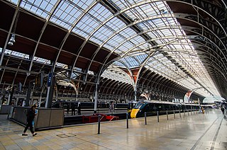
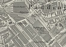
Paddington, also known as London Paddington, is a Central London railway terminus and London Underground station complex, located on Praed Street in the Paddington area. The site has been the London terminus of services provided by the Great Western Railway and its successors since 1838. Much of the main line station dates from 1854 and was designed by Isambard Kingdom Brunel.

<span class="mw-page-title-main">Baker Street tube station</span> London Underground station

Baker Street is a London Underground station at the junction of Baker Street and the Marylebone Road in the City of Westminster. It is one of the original stations of the Metropolitan Railway (MR), the world's first underground railway, opened on 10 January 1863.

<span class="mw-page-title-main">Bayswater tube station</span> London Underground station

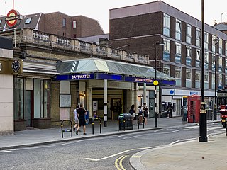
Bayswater is a London Underground station in the Bayswater area of the City of Westminster. The station is on the Circle and District lines, between Notting Hill Gate and Paddington stations and is in Travelcard Zone 1. It is less than 100 metres (330 ft) away from the Central line's Queensway station.

<span class="mw-page-title-main">South Kensington tube station</span> London Underground station

South Kensington is a London Underground station in the district of South Kensington, south west London. It is served by the District, Circle and Piccadilly lines. On the District and Circle lines it is between Gloucester Road and Sloane Square, and on the Piccadilly line between Gloucester Road and Knightsbridge. It is in Travelcard Zone 1. The main station entrance is located at the junction of Old Brompton Road (A3218), Thurloe Place, Harrington Road, Onslow Place and Pelham Street. Subsidiary entrances are located in Exhibition Road giving access by pedestrian tunnel to the Natural History, Science and Victoria and Albert Museums. Also close by are the Royal Albert Hall, Imperial College London, the Royal College of Music, the London branch of the Goethe-Institut and the Ismaili Centre.

<span class="mw-page-title-main">Richmond station (London)</span> London Underground, London Overground and National Rail station

Richmond, also known as Richmond (London), is a National Rail station in Richmond, Greater London on the Waterloo to Reading and North London Lines. South Western Railway services on the Waterloo to Reading Line are routed through Richmond, which is between North Sheen and St Margarets stations, 9 miles 57 chains (15.6 km) down the line from London Waterloo. For London Overground and London Underground services, the next station is Kew Gardens.

<span class="mw-page-title-main">Edgware Road tube station (Circle, District and Hammersmith & City lines)</span> London Underground station on the Circle, District and Hammersmith & City lines

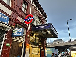
Edgware Road is a London Underground station on the Circle, District and Hammersmith & City lines, located on the corner of Chapel Street and Cabbell Street, within Travelcard zone 1. A separate station of the same name but served by the Bakerloo line is located about 150 metres away on the opposite side of Marylebone Road.

<span class="mw-page-title-main">Euston Square tube station</span> London Underground station

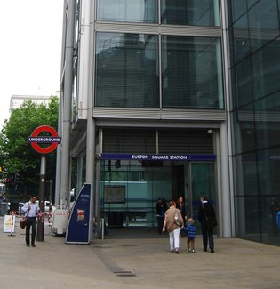
Euston Square is a London Underground station at the corner of Euston Road and Gower Street, just north of University College London – its main (south) entrance faces the tower of University College Hospital. The multi-interchange Euston station is beyond Euston Square Gardens, which is one street east. The station is between Great Portland Street and King's Cross St Pancras on the Circle, Hammersmith & City and Metropolitan lines in Travelcard Zone 1.

<span class="mw-page-title-main">Gloucester Road tube station</span> London Underground station

Gloucester Road is a London Underground station in Kensington, west London. The station entrance is located close to the junction of Gloucester Road and Cromwell Road. Close by are the Cromwell Hospital and Baden-Powell House.

<span class="mw-page-title-main">Great Portland Street tube station</span> London Underground station

Great Portland Street is a London Underground station near Regent's Park. It is between Baker Street and Euston Square on the Hammersmith & City, Circle and Metropolitan lines. Great Portland Street station is listed as a building of National Significance and lies in Travelcard Zone 1.

<span class="mw-page-title-main">Metropolitan Railway</span> Underground railway in London 1863–1933

The Metropolitan Railway was a passenger and goods railway that served London from 1863 to 1933, its main line heading north-west from the capital's financial heart in the City to what were to become the Middlesex suburbs. Its first line connected the main-line railway termini at Paddington, Euston, and King's Cross to the City. The first section was built beneath the New Road using cut-and-cover between Paddington and King's Cross and in tunnel and cuttings beside Farringdon Road from King's Cross to near Smithfield, near the City. It opened to the public on 10 January 1863 with gas-lit wooden carriages hauled by steam locomotives, the world's first passenger-carrying designated underground railway.

<span class="mw-page-title-main">Turnham Green tube station</span> London Underground station

Turnham Green is a London Underground station in Chiswick of the London Borough of Hounslow, west London. The station is served by the District and Piccadilly lines although currently Piccadilly line trains normally stop at the station only at the beginning and end of the day, running through non-stop at other times. To the east, District line trains stop at Stamford Brook and Piccadilly line trains stop at Hammersmith. To the west, District line trains run to either Chiswick Park or Gunnersbury and Piccadilly line trains stop at Acton Town. The station is in both Travelcard Zone 2 and Zone 3.

<span class="mw-page-title-main">Westbourne Park tube station</span> London Underground station

Westbourne Park is a London Underground station in the Notting Hill area of the Royal Borough of Kensington and Chelsea. It is on the Circle and Hammersmith and City lines, between Ladbroke Grove and Royal Oak stations, and is in Travelcard Zone 2.

<span class="mw-page-title-main">Gunnersbury station</span> London Underground and London Overground station

Gunnersbury is a London Overground and London Underground station in Gunnersbury in London, England on the North London line. The station opened on 1 January 1869 and is served by District line trains to and from Richmond, and by Arriva Rail London on the London Overground network. On the District line the station is between Turnham Green and Kew Gardens, and on the North London line it is between South Acton and Kew Gardens.

<span class="mw-page-title-main">Ravenscourt Park tube station</span> London Underground station

Ravenscourt Park is a London Underground station located in west Hammersmith, west London. The station is served by the District line and is between Hammersmith and Stamford Brook stations.

<span class="mw-page-title-main">Hammersmith tube station (Circle and Hammersmith & City lines)</span> London Underground station

Hammersmith is a London Underground station in Hammersmith. It is the western terminus of the Circle and Hammersmith & City lines. The station is in Travelcard Zone 2.

<span class="mw-page-title-main">Edgware Road tube station (Bakerloo line)</span> London Underground station on the Bakerloo line

Edgware Road is a London Underground station on the Bakerloo line, located in the City of Westminster. It is between Paddington and Marylebone stations on the line and falls within Travelcard zone 1. The station is located on the north-east corner of the junction of Edgware Road, Harrow Road and Marylebone Road. It is adjacent to the Marylebone flyover.

The transport system now known as the London Underground began in 1863 with the Metropolitan Railway, the world's first underground railway. Over the next forty years, the early sub-surface lines reached out from the urban centre of the capital into the surrounding rural margins, leading to the development of new commuter suburbs. At the turn of the nineteenth century, new technology—including electric locomotives and improvements to the tunnelling shield—enabled new companies to construct a series of "tube" lines deeper underground. Initially rivals, the tube railway companies began to co-operate in advertising and through shared branding, eventually consolidating under the single ownership of the Underground Electric Railways Company of London (UERL), with lines stretching across London.

<span class="mw-page-title-main">Paddington tube station (Bakerloo, Circle and District lines)</span> London Underground station

Paddington is a London Underground station served by the Bakerloo, Circle and District lines. It is located on Praed Street to the south of Paddington mainline station and has entrances from Praed Street and from within the mainline station. On the Bakerloo line the station is between Warwick Avenue and Edgware Road and on the Circle and District lines it is between Bayswater and Edgware Road. It is in London Fare Zone 1.

References

  1. 1 2 3 "Circle Line, Topology". Clive's Underground Line Guides. Retrieved 25 February 2017.
  2. "Step free Tube Guide" (PDF). Transport for London . April 2021. Archived (PDF) from the original on 15 May 2021.
  3. "Out of Station Interchanges" (XLSX). Transport for London. 16 June 2020. Retrieved 5 November 2020.
  4. "Station Usage Data" (CSV). Usage Statistics for London Stations, 2018. Transport for London. 23 September 2020. Archived from the original on 14 January 2023. Retrieved 11 October 2023.
  5. "Station Usage Data" (XLSX). Usage Statistics for London Stations, 2019. Transport for London. 23 September 2020. Archived from the original on 9 November 2020. Retrieved 9 November 2020.
  6. "Station Usage Data" (XLSX). Usage Statistics for London Stations, 2020. Transport for London. 16 April 2021. Retrieved 1 January 2022.
  7. "Station Usage Data" (XLSX). Usage Statistics for London Stations, 2021. Transport for London. 12 July 2022. Retrieved 7 September 2022.
  8. "Station Usage Data" (XLSX). Usage Statistics for London Stations, 2022. Transport for London. 4 October 2023. Retrieved 10 October 2023.
  9. Standard Tube Map (PDF) (Map). Not to scale. Transport for London. November 2022. Archived (PDF) from the original on 7 November 2022. Retrieved 12 November 2022.
  10. 1 2 3 4 5 6 7 Rose 1999.
  11. Walford 1878.
  12. Wolmar 2005, p. 32.
  13. 1 2 3 Day & Reed 2010, p. 14.
  14. Day & Reed 2010, p. 10.
  15. Wolmar 2005, p. 60.
  16. H.W. Tyler (29 June 1864). "Extract for the Accident at Bishops Road on 9th May 1864" (PDF). Retrieved 14 December 2019.
  17. 1 2 3 4 Day & Reed 2010, p. 16.
  18. Jackson 1986, pp. 39–40.
  19. Bruce 1983, p. 11.
  20. Lee 1956, p. 29.
  21. "Services on London Underground's Circle line to be extended to Hammersmith". Transport for London. 5 March 2009. Retrieved 25 February 2017.
  22. Rail distance calculated from kilometerage data at "Circle Line, Toplogy". Clive's Underground Line Guides. Retrieved 25 February 2017.
  23. "Paddington station works completed ahead of schedule". Transport for London. 23 December 2013. Retrieved 25 February 2017.
  24. Jackson 1984, p. 330.
  25. "Timetables". Transport for London . Retrieved 26 February 2017.
  26. "Buses from Paddington" (PDF). Transport for London. 19 November 2016. Archived from the original (PDF) on 5 March 2017. Retrieved 26 February 2017.

Bibliography

  • Bruce, J Graeme (1983). Steam to Silver. A history of London Transport Surface Rolling Stock. Capital Transport. ISBN   0-904711-45-5.
  • Day, John R.; Reed, John (2010) [1963]. The Story of London's Underground (11th ed.). Capital Transport. ISBN   978-1-85414-341-9.
  • Jackson, Alan (1984) [1969]. London's Termini (New Revised ed.). London: David & Charles. ISBN   0-330-02747-6.
  • Jackson, Alan (1986). London's Metropolitan Railway. David & Charles. ISBN   0-7153-8839-8.
  • Lee, Charles E. (1956). The Metropolitan District Railway. The Oakwood Press. ASIN   B0000CJGHS.
  • Rose, Douglas (1999) [1980]. The London Underground, A Diagrammatic History. Douglas Rose/Capital Transport. ISBN   1-85414-219-4.
  • Walford, Edward (1878). "XVIII". Underground London: Its railways, subways and sewers. Vol. 5. Cassell, Petter & Galpin. Retrieved 18 August 2017 via British History Online.{{cite book}}: |work= ignored (help)
  • Wolmar, Christian (2005) [2004]. The Subterranean Railway: How the London Underground Was Built and How It Changed the City Forever. Atlantic Books. ISBN   978-1-84354-023-6.