Related Research Articles

Barrow-upon-Soar railway station serves the large village of Barrow-upon-Soar in Leicestershire, England. The station is located on the Midland Main Line between Leicester and Loughborough, 108 miles 52 chains (174.9 km) north of St Pancras.

Great Easton is a village and civil parish in the Harborough district of Leicestershire, England. The parish had a population of 558 according to the 2001 census, increasing to 671 at the 2011 census.

Saxby railway station was a station serving the villages of Saxby and Freeby, Leicestershire. It was located between the two villages.

Luffenham railway station is a former station of the Syston and Peterborough Railway serving the villages of North and South Luffenham, Rutland.

Wakerley and Barrowden railway station is a former railway station in Wakerley, Northamptonshire, England which also served the nearby village of Barrowden, Rutland. It was owned by the London and North Western Railway but from 1883 to 1916 was also served by trains of the Great Northern Railway.

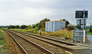
Ketton and Collyweston railway station is a former station serving the villages of Ketton, Geeston, Aldgate and Collyweston, Rutland. It is located in Geeston adjacent to a level crossing on the Ketton to Collyweston road. It is under half a mile from Ketton but over a mile from Collyweston. It closed in 1966.

Morcott railway station is a former station in Rutland, near the village of Morcott.

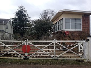
Gretton railway station was a railway station near Gretton, Northamptonshire. It was on the Nottingham direct line of the Midland Railway of the Midland Railway. The steps up to the former platforms can still be seen, but the station building itself is in private ownership.

Castle Ashby & Earls Barton railway station is a former railway station in Northamptonshire on the former Northampton and Peterborough Railway, a line which connected Peterborough and Northampton.
Asfordby railway station was a station serving the villages of Asfordby and Kirby Bellars in Leicestershire. The station was situated at a level crossing on the road between the two villages. It opened in 1846 and was originally named Kirby, but had been renamed Asfordby by 1863. It closed to passengers in 1951 but remained in use for goods until 1964.
The Rugby and Stamford Railway was an early railway in England built in 1850. The London and Birmingham Railway had already built a branch from Blisworth to serve Northampton and extend to Peterborough. The success of this, the Northampton and Peterborough Railway encouraged the directors to look for other ventures. They decided upon a branch from Rugby to Stamford which would link up with other new railways in the east of the country.

Clifton Mill railway station was a railway station serving Clifton-upon-Dunsmore in the English county of Warwickshire. It was opened on the Rugby and Stamford Railway in 1864.

Yelvertoft and Stanford Park railway station was a railway station that served the villages of Stanford-on-Avon and Yelvertoft in Northamptonshire, England. It was close to the stately home of Stanford Hall nearby in Leicestershire. It was opened as Stanford Hall on the Rugby and Stamford Railway in 1850.

Welford and Kilworth railway station was a railway station serving Welford and the villages of North Kilworth and South Kilworth in Leicestershire, England. It was opened as Welford on the Rugby and Stamford Railway in 1850.
Theddingworth railway station was a railway station serving Theddingworth in Leicestershire, England. It was opened on the Rugby and Stamford Railway in 1850.
Lubenham railway station was a railway station serving Lubenham in Leicestershire, England. It was opened on the Rugby and Stamford Railway in 1850.

Piddington was a railway station on the former Bedford to Northampton Line. Despite its name, the station was located close to the village of Horton in Northamptonshire, approximately 2 miles (3.2 km) from the village of Piddington.
Roade was a railway station serving the Northamptonshire village of the same name on the West Coast Main Line. Roade Station opened in 1838 as the principal station for Northampton, but its importance diminished upon the opening of the Northampton and Peterborough Railway in 1845. The construction of the Northampton Loop Line in 1875 made Roade a junction station, and it survived until 1964.

Kilsby and Crick was a railway station on the Northampton Loop Line serving the villages of Kilsby and Crick in Northamptonshire. It was located to the eastern side of where the railway crossed the A5 road at the site now occupied by the Daventry International Rail Freight Terminal. It was located about a mile from Kilsby and one and a half from Crick.

Chilvers Coton was a railway station on the Coventry to Nuneaton Line, which served the Chilvers Coton area of Nuneaton, south of the town centre. It opened in 1850, along with the line, and was closed in 1965 when passenger services on the route were withdrawn.
References
52°31′46″N0°43′30″W / 52.5295°N 0.7249°W
| | This article on a railway station in the East Midlands is a stub. You can help Wikipedia by expanding it. |