
Hunterdon County is a county located in the western section of the U.S. state of New Jersey. As of the 2018 Census estimate, the county's population was 124,714, making it the state's 18th-most populous county, representing a 2.6% decrease from the 128,349 enumerated in the 2010 United States Census, in turn increasing by 6,360 (+5.2%) from the 121,989 counted in the 2000 Census. Its county seat is Flemington.
Route 31 is a state highway in New Jersey, United States. It runs 48.93 mi (78.75 km) from U.S. Route 1 Business /US 206 in Trenton, Mercer County, north to an intersection with US 46 in Buttzville in White Township, Warren County. Along the way, Route 31 heads through the communities of Flemington, Clinton and Washington. Most of the highway is state-maintained; however, the section within the city limits of Trenton is maintained by the city. Much of Route 31 is a two-lane highway that passes through farmland, woodland, and mountainous areas. Two portions of the route—from Trenton to Pennington and from Ringoes to Clinton—consist of more development.

Clinton is a town in Hunterdon County, New Jersey, United States, located on the South Branch of the Raritan River. As of the 2010 United States Census, the town's population was 2,719, reflecting an increase of 87 (+3.3%) from the 2,632 counted in the 2000 Census, which had in turn increased by 578 (+28.1%) from the 2,054 counted in the 1990 Census. Despite its relatively small population, Clinton is the predominant control city for Interstate 78 heading west from Newark.
Clinton Township is a township in Hunterdon County, New Jersey, United States. As of the 2010 United States Census, the township's population was 13,478, reflecting an increase of 521 (+4.0%) from the 12,957 counted in the 2000 Census, which had in turn increased by 2,141 (+19.8%) from the 10,816 counted in the 1990 Census.
East Amwell Township is a township in Hunterdon County, New Jersey, United States. As of the 2010 United States Census, the township's population was 4,013, reflecting a decline of 442 (-9.9%) from the 4,455 counted in the 2000 Census, which had in turn increased by 123 (+2.8%) from the 4,332 counted in the 1990 Census.

Franklin Township is a township in central Hunterdon County, New Jersey, United States. As of the 2010 United States Census, the township's population was 3,195, reflecting an increase of 205 (+6.9%) from the 2,990 counted in the 2000 Census, which had in turn increased by 139 (+4.9%) from the 2,851 counted in the 1990 Census. Most of the township lies on the Hunterdon Plateau with only the eastern section along the South Branch Raritan River being on the lower part of the Newark Basin.

Raritan Township is a township in Hunterdon County, New Jersey, United States. As of the 2010 United States Census, the township's population was 22,185, reflecting an increase of 2,376 (+12.0%) from the 19,809 counted in the 2000 Census, which had in turn increased by 4,193 (+26.9%) from the 15,616 counted in the 1990 Census. The southeast part of the township is in the Amwell Valley, while the northwestern part is on the Hunterdon Plateau.

Readington Township is a township located in the easternmost portion of Hunterdon County, New Jersey, United States. As of the 2010 United States Census, the township's population was 16,126, reflecting an increase of 323 (+2.0%) from the 15,803 counted in the 2000 Census, which had in turn increased by 2,403 (+17.9%) from the 13,400 counted in the 1990 Census.

Pittstown is an unincorporated community located at the intersection of the boundaries of Alexandria, Franklin and Union townships in Hunterdon County, New Jersey, United States. The area is named after William Pitt. The area is served as United States Postal Service ZIP Code 08867. The area was named Hofftown in the 18th century after landowner Lawrence Hoff.

Whitehouse is an unincorporated community located within Readington Township in Hunterdon County, New Jersey, United States. The community lies along the Jersey Turnpike, just west of Mechanicsville.
Readington Village is an unincorporated community located within Readington Township in Hunterdon County, New Jersey, United States, that is centered on the converging of Readington Road, Hillcrest Road, Centerville Road and Brookview Road. It is located on Holland Brook, originally named Amanmechunk, which means large creek in the Unami dialect. The area was inhabited by the Raritan prior to the arrival of European settlers. The Native Americans who lived near Readington Village travelled to the coast during the summer for fish and clams. Such a trip is mentioned in an Indian deed transferring lands around Holland Brook to English and Dutch settlers. The deed mentions two of the natives, who lived at Readington: Metamisco and Wataminian.

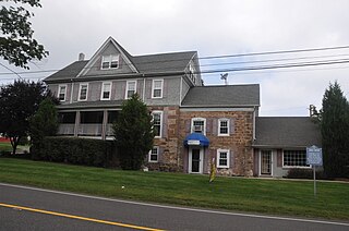
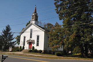
Stanton is an unincorporated community located within Readington Township in Hunterdon County, New Jersey, United States. The community dates back to the 17th century and was settled by the Dutch. It was originally called Housel's after Johannes Housel, who had a farmstead along Dreahook Road in the mid-18th century. After the death of William Housel, the last owner of the Housel farmstead, it then carried the name of Waggoner's Hill after landowner William Waggoner. The community took the descriptive name of Mount Pleasant during the beginning of the 20th century and would finally become known as Stanton to distinguish it from another Mount Pleasant. The name "Stanton" was taken from James Logan's Pennsylvania estate: Stenton, which in turn is named for the Scottish village where his father was born. Logan was a proprietor of West Jersey, a mayor of Philadelphia, and a Chief Justice of the Supreme Court of Pennsylvania. Logan Way in Readington is named after him, as well as Logan Circle and the Logan neighborhood in Philadelphia and Logan Township in Clinton County, Pennsylvania. In the 1830s, a Reformed Church and a general store were built, both of which are present today.

Potterstown is an unincorporated community along the border of Clinton and Readington townships in Hunterdon County, New Jersey, United States. Potterstown once was home to taverns, a blacksmith, a store house, a wheelwright and a pottery shop which gave the hamlet its name. It is along an old Raritan Path and on the Jersey Turnpike. Aray Van Guinea, a free African-American, donated land for the construction of the German Lutheran Church. Robert Livingston, James Alexander, his son Lord Stirling and John Stevens all owned land here at some time. John Taylor, an officer with the Hunterdon 4th Militia built a house and mill, which was used during the Revolutionary War to provide soldiers with food. Taylor's Mill has plans to become the fourth Readington Museum.

Dreahook is an unincorporated community in Readington Township in Hunterdon County, New Jersey, United States at the intersection of CR-620/Dreahook Rd and CR 523. The name is a corruption of Driehoek, which is the Dutch word for triangle. It was likely named for the triangle created by the settlement in its relation to the early roads to Flemington, Whitehouse Station, Readington Village and Pleasant Run, which have since been rerouted. Dreahook Creek and Holland Brook both pass through the area of the former village. Dreahook village once had blacksmith shop, a school and a store. Settlers farmed the land here because of the rich soil along the base of Cushetunk Mountain. There are still numerous farms in the area, including the Readington River Buffalo Farm between Dreahook and Stanton.

Three Bridges is an unincorporated community located within Readington Township in Hunterdon County, New Jersey, United States, on the South Branch Raritan River. It is named for the three original bridges which crossed the river.
Barley Sheaf was an unincorporated community located within Readington Township in Hunterdon County, New Jersey, United States. It was named for the grain once grown in the region. The hamlet was on Barley Sheaf Road between County Route 629 (CR 629) and CR 523. The hamlet at one time housed a general store, a post office, blacksmith, creamery, a hotel and numerous farmsteads. Today only farms remain of the hamlet. The hamlet also carried the names of Farmersville and Campbellsville after Catherine Campbell, who ran the hotel in the area.

Centerville was a hamlet within Readington Township in Hunterdon County, New Jersey, United States. The community was located along Campbell's Brook and Old York Road. Centerville grew up because of a tavern that marked the halfway point on the long Swift Sure Stage Line route from New York to Philadelphia. The hamlet had a school, a store, a post office, a church and blacksmith. When the railroads and newer roads were built, Centerville saw few visitors and today all the buildings there are residences.
Darts Mills is a historic unincorporated community located within Readington Township in Hunterdon County, New Jersey, United States. It is located on the South Branch of the Raritan River, and several mills were built there in the early 18th century. At its height, a merchant, blacksmith, store and complex of mills were here. The last mill at this site burnt down in 1994. Foundation walls and a mill race remain at the site today. On April 29, 1982, Dart's Mill was added to the National Register of Historic Places.

Rockefellows Mills is an unincorporated community located within Raritan Township in Hunterdon County, New Jersey, United States. The settlement is located along the South Branch Raritan River near Three Bridges. The river is spanned in the area by a 1910-constructed Pratt through truss bridge. Most of the area within the Raritan Township side of the river is forested however on the north side of the river in Readington Township, some farmland dots the area.

Riverside is an unincorporated community located within Readington Township in Hunterdon County, New Jersey, United States.


