This article includes a list of general references, but it lacks sufficient corresponding inline citations .(January 2011) |
Shirland Township | |
|---|---|
Township | |
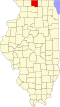
 Location in Winnebago County | |
| Coordinates: 42°28′08″N89°12′12″W / 42.46889°N 89.20333°W | |
| Country | United States |
| State | Illinois |
| County | Winnebago |
| Established | November 6, 1849 |
| Government | |
| • Supervisor | Helen J. Weaver |
| Area | |
• Total | 19.28 sq mi (49.9 km2) |
| • Land | 19.2 sq mi (50 km2) |
| • Water | 0.08 sq mi (0.2 km2) 0.41% |
| Elevation | 801 ft (244 m) |
| Population (2010) | |
| 958 | |
| • Density | 51.5/sq mi (19.9/km2) |
| Time zone | UTC-6 (CST) |
| • Summer (DST) | UTC-5 (CDT) |
| FIPS code | 17-201-69615 |
| [2] [3] | |
Shirland Township is located in Winnebago County, Illinois. It includes the unincorporated community of Shirland.
Contents
As of the 2010 census, its population was 988 and it contained 423 housing units. [4]