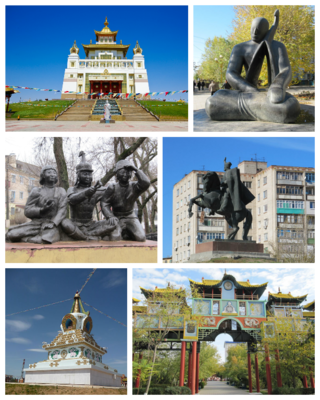
Elista is the capital city of the Republic of Kalmykia, Russia.
Kalmykia, officially the Republic of Kalmykia, is a republic of Russia, located in the North Caucasus region of Southern Russia. The republic is part of the Southern Federal District, and borders Dagestan to the south and Stavropol Krai to the southwest; Volgograd Oblast to the northwest and north and Astrakhan Oblast to the north and east; Rostov Oblast to the west and the Caspian Sea to the east. Through the Caspian Depression, the Kuma river forms Kalmykia's natural border with Dagestan. Kalmykia is the only region in Europe where the Dharmic religion of Buddhism is the predominant religion.

The State Anthem of the Pridnestrovian Moldavian Republic, known by its incipit "We Sing the Praises of Transnistria" and also simply known as the Anthem of Transnistria, was written by Boris Parmenov, Nicholas Bozhko and Vitaly Pishchenko, and composed by Boris Alexandrovich Alexandrov. The anthem has lyrics in all three official languages of Transnistria: Russian, Romanian, and Ukrainian. They are, however, not all literal translations of one another. The origin of the anthem was from the Russian patriotic song "Long Live Our State", a 1943 composition that was one of the proposed songs to be the State Anthem of the Soviet Union. Boris Alexandrov's composition was, however, rejected in favor of the one submitted by his father, Alexander Alexandrov.
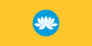
The flag of Kalmykia consists of a yellow field with a sky blue circle in the center containing a lotus. The yellow stands for the sun, the people and the religious faith of the nation. The blue represents the sky, eternity, and steadiness. The lotus is a symbol of purity, spiritual rebirth and happiness. Its five upper petals represent the continents and the lower four stand for the quarters of the globe. Together, they symbolize the will of the Kalmyks to live in friendship and to cooperate with all the nations of the world.

Gorodovikovsk is a town and the administrative center of Gorodovikovsky District of the Republic of Kalmykia, Russia, located on the Bashanta River, 240 kilometers (150 mi) west of Elista. Population: 9,565 (2010 Census); 10,940 (2002 Census); 11,902 (1989 Soviet census). It was previously known as Bashanta.
Maloderbetovsky District is an administrative and municipal district (raion), one of the thirteen in the Republic of Kalmykia, Russia. It is located in the north of the republic. The area of the district is 3,665.93 square kilometers (1,415.42 sq mi). Its administrative center is the rural locality of Malye Derbety. As of the 2010 Census, the total population of the district was 10,528, with the population of Malye Derbety accounting for 61.1% of that number.

The Russian Soviet Federative Socialist Republic, previously known as the Russian Soviet Republic and the Russian Socialist Federative Soviet Republic, and unofficially as Soviet Russia, was an independent federal socialist state from 1917 to 1922, and afterwards the largest and most populous constituent republic of the Soviet Union (USSR) from 1922 to 1991, until becoming a sovereign part of the Soviet Union with priority of Russian laws over Union-level legislation in 1990 and 1991, the last two years of the existence of the USSR. The Russian SFSR was composed of sixteen smaller constituent units of autonomous republics, five autonomous oblasts, ten autonomous okrugs, six krais and forty oblasts. Russians formed the largest ethnic group. The capital of the Russian SFSR and the USSR as a whole was Moscow and the other major urban centers included Leningrad, Stalingrad, Novosibirsk, Sverdlovsk, Gorky and Kuybyshev. It was the first socialist state in history.
Iki-Burulsky District is an administrative and municipal district (raion), one of the thirteen in the Republic of Kalmykia, Russia. Its administrative center is the rural locality of Iki-Burul. As of the 2010 Census, the total population of the district was 11,424, with the population of Iki-Burul accounting for 35.5% of that number.

Ketchenerovsky District is an administrative and municipal district (raion), one of the thirteen in the Republic of Kalmykia, Russia. It is located in the northwest of the republic. Its administrative center is the rural locality of Ketchenery. As of the 2010 Census, the total population of the district was 10,622, with the population of Ketchenery accounting for 36.8% of that number.

Lagansky District is an administrative and municipal district (raion), one of the thirteen in the Republic of Kalmykia, Russia. It is located in the southeast of the republic. The area of the district is 4,685.51 square kilometers (1,809.09 sq mi). Its administrative center is the town of Lagan. As of the 2010 Census, the total population of the district was 20,089, with the population of Lagan accounting for 71.3% of that number.
Priyutnensky District is an administrative and municipal district (raion), one of the thirteen in the Republic of Kalmykia, Russia. It is located in the west of the republic. The area of the district is 3,110.00 square kilometers (1,200.78 sq mi). Its administrative center is the rural locality of Priyutnoye. As of the 2010 Census, the total population of the district was 11,658, with the population of Priyutnoye accounting for 51.6% of that number.

Sarpinsky District is an administrative and municipal district (raion), one of the thirteen in the Republic of Kalmykia, Russia. It is located in the north of the republic. The area of the district is 3,737.63 square kilometers (1,443.11 sq mi). Its administrative center is the rural locality of Sadovoye. As of the 2010 Census, the total population of the district was 13,796, with the population of Sadovoye accounting for 47.3% of that number.

Tselinny District is an administrative and municipal district (raion), one of the thirteen in the Republic of Kalmykia, Russia. Its administrative center is the rural locality of Troitskoye. As of the 2010 census, the total population of the district was 20,051, with the population of Troitskoye accounting for 59.6%.
Yashaltinsky District is an administrative and municipal district (raion), one of the thirteen in the Republic of Kalmykia, Russia. It is located in the west of the republic. The area of the district is 2,415.84 square kilometers (932.76 sq mi). Its administrative center is the rural locality of Yashalta. As of the 2010 Census, the total population of the district was 17,178, with the population of Yashalta accounting for 27.5% of that number.

Yustinsky District is an administrative and municipal district (raion), one of the thirteen in the Republic of Kalmykia, Russia. It is located in the northeast and east of the republic. The area of the district is 7,995.61 square kilometers (3,087.12 sq mi). Its administrative center is the rural locality of Tsagan Aman. As of the 2010 Census, the total population of the district was 10,585, with the population of Tsagan Aman accounting for 56.9% of that number.

Ketchenery is a rural locality and the administrative center of Ketchenerovsky District of the Republic of Kalmykia, Russia. Population: 3,908 (2010 Census); 3,938 (2002 Census); 4,940 (1989 Soviet census).
Bolshoy Tsaryn is a rural locality and the administrative center of Oktyabrsky District of the Republic of Kalmykia, Russia. Population: 5,497 (2010 Census); 5,070 (2002 Census); 5,772 (1989 Soviet census).

Tsagan Aman is a rural locality and the administrative center of Yustinsky District and of the Tsagan Aman Rural Settlement in the Republic of Kalmykia, Russia. It is the only settlement in the Republic of Kalmykia on the Volga River, and is located about 300 kilometres (190 mi) northeast of Elista. Tsagan Aman was founded in 1798. Population: 6,027 (2010 Census); 5,926 (2002 Census); 6,545 (1989 Soviet census).
Yashalta is a rural locality and the administrative center of Yashaltinsky District of the Republic of Kalmykia, Russia. Population: 4,716 (2010 Census); 4,851 (2002 Census); 4,996 (1989 Soviet census).
